Wednesday, August 29, 2012

Surge levels exceed six feet along MS Coast, Lake Pontchartain

Caption: Storm surge in Mississippi. Source: www.bloomberg.com.

Storm surge levels exceed six feet along the Mississippi Coast and Lake Pontchartain shoreline tonight, according to NOAA Tides and Currents gauges. Persistent south winds are keeping storm surge pushed into the Mississippi Sound, which both floods the Mississippi Coast and hinders the outflow of high water in Lake Pontchartain. Meanwhile. surge levels in Shell Beach, LA, have fallen below five feet, as water is being pushed away from this community and into Lake Borgne.

High water has been reported in several communities that drain into the Gulf or Lake Pontchartrain Basin. WAFB interviewed people in the Lake Pontchartain watershed who were flooded for the first time. These people said they were not flooded from any other tropical systems, including Hurricane Katrina. Apparently, heavy rain water is not draining as quickly as normal, due to elevated water levels in Lake Pontchartain, the LA and MS coastal region.

This phenomenon is consistent with observations from Tropical Storm Debbie in Florida this past June, which flooded many communities as rainwater drained slowly due to elevated water levels in Tampa Bay. Also, SCIPP conducted 62 weather/ climate needs assessment surveys this past year, finding that several stakeholders in the Houston/ Galveston area reported slow rainwater drainage when water levels are elevated due to elevated surge levels in Galveston Bay.

Such impacts are localized, but are important for those affected. It's also important to realize that some of these flood patterns are representative of a large, slow-moving hurricane or tropical storm, which dumps large amounts of rain. Although the history books may not remember Isaac as destructive as Katrina, for some people the impacts of Isaac were worse.

Such lessons may also help us to look separately at the severe weather impacts of future hurricanes. Hurricanes generally throw a three-pronged threat at us, as we are threatened by strong winds, heavy rain and storm surge. It is helpful to think through the potential impacts for each of those hazards with any given storm, which may change drastically, depending on the size, forward speed and duration of the storm.

Surge Levels Holding Steady in Coastal Mississippi

Storm surge levels are holding steady in coastal Mississippi. In fact, we've seen some slight rises this morning, as winds have turned more to southeast and are driving water into shore. Surge levels at 10:00AM were approaching 8 feet above normal at Bay Waveland Yacht Club, MS. Here is a graphic of recent water level heights at this location. The red line represents the storm tide (total water level) and the green line represents storm surge levels (water heights above normal). Source: NOAA Tides and Currents


Source: NOAA Tides and Currents

Isaac Surge Pics


Storm surge started flooding much of coastal Mississippi, Lake Pontchartrain and locations east of the Mississippi River, including St. Bernard and Plaquemines Parishes in Southeast Louisiana, Tuesday. Here are a few pics available on the surge flooding along the shores of Lake Pontchartrain.

Power outage will kill this blog....for awhile

Hey everyone-

I'm based in Baton Rouge, which is supposedly in the cross hairs of Isaac, at least once it starts moving inland. I'm expecting to lose power sometime tonight or tomorrow morning, in which case this blog will go down for awhile. I know that's a lame excuse. I really need to hook up a gas-powered generator to keep this train rollin'!

Surge observations and reports in the wee (wii?) hours of the morning

A few surge observations in the wee hours of the morning. Or is it Wii hours of the morning? Perhaps Wii needs to make a hurricane/ surge game?

NOAA Tides and Currents reports the following surge obs as of around 1:30AM CDT Wednesday.

Location                                          Surge Height (ft)
Shell Beach, LA                             10.86
Bay Waveland Yacht Club, MS      7.28
New Canal Station, LA                   4.37
Pascagoula NOAA Lab, MS           4.26
Coast Guard, Mobile, AL                3.86
Pilots Station East, SW Pass, LA     3.55

Shell Beach, LA continues to lead the pack of observed surge obs, with a water level of nearly 11 feet above normal. Storm surge is also inundating the Mississippi Coast, with a current level of 7.28 feet above normal at Bay Waveland Yacht Club.

Slightly after midnight tonight, WAFB reported that storm surge was overtopping levees in Plaquemines Parish, LA. They specifically mentioned overtopping in the communities of Buras and Pointe-a-la Hache. Does anyone know levee heights in those areas?

Also, if anyone has surge obs, pictures or video, please comment on this blog or contact me at hneedh1@lsu.edu.

Isaac's 11.02-foot surge moves it into fifth place all-time at Shell Beach, LA

Hurricane Isaac's storm surge reached 11.02 feet at 11:36PM CDT this evening at Shell Beach, LA. Water levels were rising during the afternoon and evening as strong winds howled out of the north-northeast and northeast. In the first hours of Wednesday, water levels at Shell Beach dropped slightly, but remained close to 11 feet.

SCIPP/ SURGEDAT has identified peak surge levels for 15 tropical cyclones at Shell Beach. Isaac's 11.02-foot surge moved it into fifth place all time, surpassing water levels produced by Flossy (1956), Gustav (2008), Betsy (1965) and Ike (2008). Isaac now joins some noteworthy company for surge events in this area, and the maximum level during Isaac is just a fraction of an inch lower than Camille's surge height in this area.

Top 10 surge heights for Shell Beach, LA in the SURGEDAT database:

Rank    Storm        Year    Max Water Level (ft)
1          Katrina      2005   18.7 (storm surge)
2          Unnamed   1915   11.6 (storm tide)
3          Unnamed   1947   11.2 (storm tide)
4          Camille      1969   11.06 (storm tide)
5          Isaac           2012  11.02 (storm surge)
6          Flossy         1956  10.9 (storm tide)
7          Gustav        2008   9.53 (storm surge)
8          Betsy          1965   9.34  (storm tide)
9          Ike              2008   7.51 (storm surge)
10        Unnamed    1901   6.7  (storm tide)

Tuesday, August 28, 2012

Reed Timmer's streaming surge video


Check out Reed Timmer's streaming surge video, which is broadcast live from Waveland, MS this afternoon. Footage in the past hour showed water streaming in over the roadway. 

Here is the link:


Shell Beach leads the pack

                               Source: http://www.ssd.noaa.gov/goes/east/gmex/avn-l.jpg

Hurricane Isaac became better organized this afternoon as the outer bands of rain and wind lashed the Gulf Coast from Southeast Louisiana to the Florida panhandle. Isaac's surge began pushing water into coastal communities this afternoon. As of approximately 4PM CDT, Shell Beach, LA leads the pack with a storm surge of 6.83 feet and a storm tide of 7.81 feet. Here is a list of selected obs along the Gulf Coast.

Location                                     Storm Surge (ft)     Storm Tide (ft)
Shell Beach, LA                                     6.83                      7.81
Bay Waveland Yacht Club                     4.75                      5.62
Pascagoula, MS                                     4.22                      4.46
Coast Guard Sector, Mobile, AL           3.47                      4.16
Pensacola, FL                                        3.47                      4.01
Pilots Station East, SW Pass, LA          3.22                      3.39
Dauphin Island, AL                               3.16                      3.66
Grand Isle, LA                                       1.53                      1.92
East Bank1, Norco, B, Labranche, LA  1.41                      1.79

Data Courtesy NOAA Tides and Currents


Water level graph from Shell Beach, LA. Graphic courtesy: NOAA Tides and Currents

Water levels at Shell Beach have been steadily rising today. As of 12:00PM CDT, the observed water level approached six feet, which was about four feet above normal. This means the storm surge was approximately four feet. Water levels have risen at an even faster rate since noon, with the water level now approaching eight feet, which is nearly seven feet above normal.

A look at Gustav (2008)

A map of Hurricane Gustav's (2008) hourly position and intensity, as well as observed storm surge and storm tide levels.

A zoomed-in map of Hurricane Gustav's (2008) hourly track and intensity, as well as observed storm surge and storm tide levels.

Hurricane Gustav entered the Gulf of Mexico as a category-3 hurricane, then weakened into a category-2 storm before making landfall in South Louisiana. The highest surge levels were located to the east of the Mississippi River, in places like Bay Gardene, Shell Beach, and even along the Mississippi Coast. Northeast Bay Gardene, LA, observed the highest water levels, with a storm surge of 12.5 feet and storm tide of 13.63 feet.

Note that Gustav tracked to the west of the Mississippi River, but the peak surges occurred on east side of river. Even portions of the Mississippi Coast observed surge levels greater than 8 feet, which were higher than locations closer to the point of landfall. This is an example of how effectively water piles up on the eastern levees of Plaquemines Parish, in eastern communities of St. Bernard Parish, such as Shell Beach, and in the Mississippi Sound.

Isaac is different than Gustav in several ways- it has a broader wind field but is less intense, and the latest forecasts suggest it will track farther east than Gustav. However, it may be helpful to look at these observed water levels for context. In the previous blog, I posted a similar map for Hurricane Georges (1998). The NHC forecast map places Isaac's track somewhere between these two systems, but most likely with less intensity. Even if Isaac is quite different than these storms, in terms of size, intensity and exact track/ point of landfall, it may be helpful to gain familiarity with surge patterns seen in these storms that approached LA from the southeast.

A closer look at Georges (1998)

Ezra Boyd, a good friend and faithful follower of the storm surge blog, posted the following question just a few minutes ago:

The current forecast has a trajectory just to the west of Georges. Do you have any thoughts on how that impacts surge heights?

This is a great question, Ezra!

I spent some time today creating maps that depict the hourly position/ intensity of Georges, as well as observed storm surge and storm tide levels. I've pasted two versions of this map below- a full Gulf map and a zoomed in version.

 Zoomed out map of Hurricane Georges (1998)

Zoomed in map of Hurricane Georges (1998)

Some notes: Hurricane Georges tracked across the Gulf of Mexico as a category-2 hurricane, before making landfall on the Mississippi Coast. The peak observed storm surge was 9.6 feet at Pascagoula, MS, while storm tides of 12.14 feet were observed on the MS Coast and 10.83 feet on the AL Coast. High water levels in LA generally were 4-6 feet in Lake Pontchartrain, 6-8 feet on east side of New Orleans. The peak surge level in LA was 8.9 feet at NE Bardene Bay, which is 13 miles ESE of Pointe a la Hache.

A few substantial differences are seen with the current storm, as Isaac is tracking farther west, and, perhaps more importantly, Isaac is less intense. Although the NHC is still predicting that Isaac attains hurricane strength, it is still a tropical storm as it approaches the coast. This is important because research by Jordan and Clayson (2008) and Needham and Keim (in press), has indicated that pre-landfall winds correlate better with surge heights than wind speeds at landfall. So this means that a storm like Georges, which traverses the Gulf of Mexico as a category-2 storm will often be able to push more water than a storm which develops into hurricane strength (even if attaining cat-2 status) just before landfall. However, we must always be careful, because other factors, like storm size, also play into the storm surge equation.

That said, I wanted to include these graphics of Hurricane Georges for comparison sake, and also so we can see historic surge heights relative to each other. It is interesting to see some distinct patterns on the Georges map, such as a 4-6 foot surge range consistent along Lake Pontchartrain. Not exactly sure how the more westward track affects surge heights, but one may presume, all things being equal, that this would serve to increase heights in LA, and perhaps lower heights in AL and FL.


Monday, August 27, 2012

Large Isaac heads towards SE Louisiana/ Mississippi

Hurricane Isaac spins in the Gulf of Mexico, as the system approaches the Louisiana and Mississippi Coasts. This infrared satellite image shows the large extent of Isaac. Source: National Hurricane Center. Link: http://www.ssd.noaa.gov/goes/east/gmex/avn-l.jpg


The National Hurricane Center forecasts Isaac to become a hurricane before making landfall in Southeast Louisiana or Mississippi. As Isaac is a large storm, some of the outer rain bands were already reaching the coast this evening.

Sunday, August 26, 2012

Looking back at Hurricane Georges (1998)


The National Hurricane Center moved Isaac's forecast track to the west today, as some well-known models, like the GFS, GFDL and HWRF models predict a more westward solution for Isaac's track. The new track and intensity forecasts resemble Hurricane Georges (1998), although Georges was a category-2 hurricane for most of its track in from Cuba.

  
 This map shows the historic track for Georges. Hourly position and intensity data are provided by Dr. Elsner and Dr. Jagger at Florida State University. The image looks a bit small on this blog, but it can be downloaded. Check back later for surge data to be added to this plot. The SCIPP program has identified 68 high water marks from this storm, which are now included in the SURGEDAT database. Until these points are plotted in a color-coded map (again, check back soon), here is a list of selected high water mark observations from Hurricane Georges.

Hurricane Georges (1998) Storm Surge Observations (feet)

Fort Morgan, AL   11.9
Pascagoula- Bayou Chico, MS 9.6
West Mobile Bay, AL 9.3
Gulf Shores, AL 9
Biloxi (Point Cadet) 8.9
 NE Bardene Bay, LA 8.9
Downtown Mobile, AL 8.5
Gulfport Harbor, MS 8.1
Pensacola Beach, FL 7.7
Bay St. Louis, MS 5.8
Panama City Beach, FL 5.2
Lake Pontchartrain Causeway, LA 4.7
Frenier, LA (West end Lake Pont) 4.7

Storm Tide Levels (Tides not removed from data)
Mississippi Coast high water mark 12.14
Alabama Coast high water mark 10.83
Mobile River, AL 8.94
Navarre Beach, FL 8.5
Pascagoula River, MS 8.36

Those are some selected observations. Again, Georges was more intense at this stage of the game than Isaac, and recent research has indicated pre-landfall winds correlate better with surge heights than winds at landfall (Jordan and Clayson 2008; Needham and Keim 2012- in press). This hopefully means that Isaac's surge levels will be somewhat lower than Georges' if Isaac does indeed follow a similar track to Georges.

Stay tuned for more surge-related information as Isaac approaches the U.S. Gulf Coast.


Saturday, August 25, 2012

Keep an eye out, Louisiana and Mississippi

A note to our friends in Louisiana and Mississippi. Keep an eye out for Isaac. The official NHC statement forecasts Isaac to most likely approach the FL Panhandle or Big Bend area, although the latest discussion indicates some uncertainty in the track. Some models are predicting a westward jog in the track as Isaac approaches the Gulf of Mexico, and models differ on the timing and duration of this westward turn, if it even occurs.

Some credible models, like the GFS model, have come up with a more westward solution, forecasting Isaac to approach Louisiana or Mississippi. So stay tuned friends in the SCIPP (Southern Climate Impacts Planning Program) region. (The Gulf Coast region for SCIPP includes TX, LA, MS, and at this time any impacts on Texas look minimal.)

Also, our friends in SE Louisiana should remember that water tends to pile up here during a prolonged east wind, particularly in places east of the Mississippi River, like eastern portions of Plaquemines Parish, Breton Sound, St. Bernard Parish and small communities in that region, like Shell Beach, Delacroix, Hopedale, as well as Lake Borgne and Lake Pontchartrain. We have seen high water levels in these areas before, even if hurricanes pass to the east.

The "spaghetti models" show a wide range of solutions right now, as various models predict Isaac to track from Louisiana in the west to the Florida "Big Bend" area in the east.

Time to dust off those old newspapers

It's time to dust off those old newspapers because as we look for storms that resemble Isaac, we may have to go way back in time. I'm talking late 1800s and early 1900s. We haven't seem a storm quite like this in some time. In more recent history, Ivan slammed the Florida Panhandle in 2004, but that storm was a monster in the Caribbean and all the way through landfall. Elena and Kate were two hurricanes in 1985 that came off the coast of Cuba and tracked towards the Florida Panhandle. However, Elena stopped in the northeast Gulf for a lunch break, got indecisive, and decided to do an about face. Kate was stronger than Isaac was, at least near Cuba and on entry to Gulf, then became a category-3 hurricane for about 24 hours before slamming the coast near Cape San Blas. We will keep an eye on Isaac, but the current forecast is quite different than either of these storms.

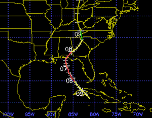
To find storms that resemble Isaac, we may have to go back to 1896 and 1903. In July 1896, a tropical storm moved north off the Cuba coast, then strengthened into a category-2 hurricane before making landfall between Pensacola and Panama City, Florida. In September 1903, a category-1 hurricane made landfall in eastern Florida, near Palm Beach, then diminished into a tropical storm as it crossed the state, emerged into the Gulf of Mexico south of Tampa, then strengthened into a category-1 hurricane before "turning the corner" near Cape San Blas, and making landfall near Panama City. The tracking maps for these storms are provided below. Yellow indicates tropical storm strength, while red indicates hurricane-force strength. Source: Unisys Corporation.

The July 1896 hurricane

The September 1903 hurricane

Surge history associated with these storms

The 1896 storm most likely produced a 10-foot surge near Dune Allen Beach, Florida. This surge event was recently removed from the official SURGEDAT database because it is speculative and based on damage reports. The 1903 storm produced a 10-foot storm tide at Apalachicola.

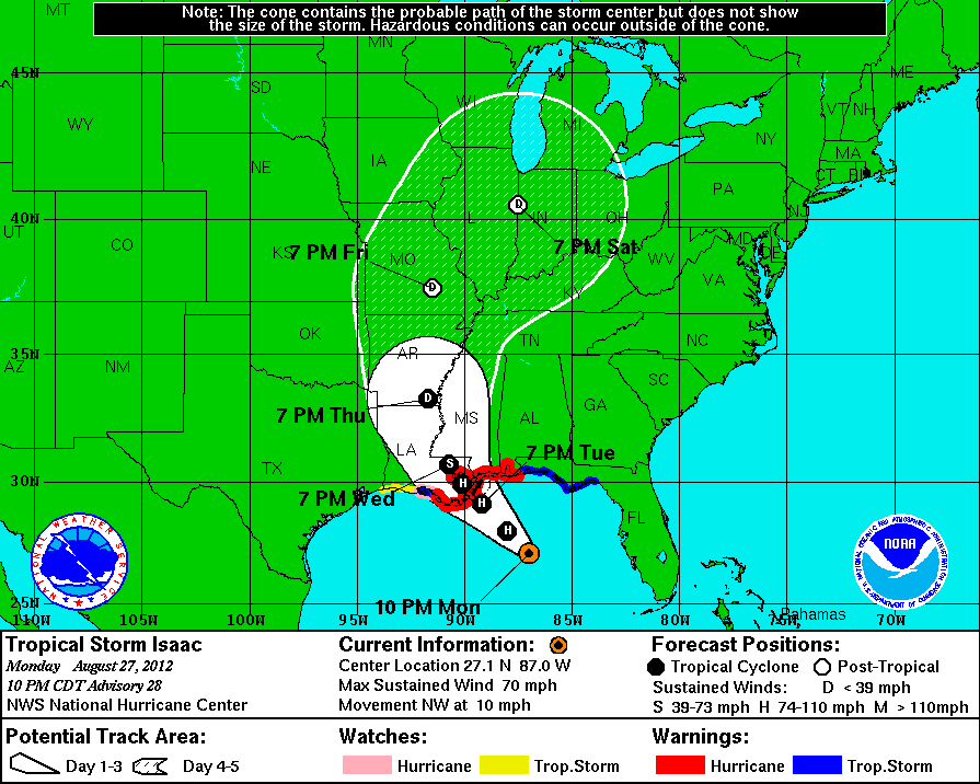
It is interesting that these events produced surges this high, particularly the 1903 event that emerged over the Gulf of Mexico for a limited time and never exceeded category-1 strength. These relatively high levels may be further evidence that the "Big Bend" area of Florida, particularly from Apalachicola east, is an area that experiences enhanced surge levels. The shallow offshore water and concave-shaped coast pile up water very effectively in this region. According to the current NHC forecast, Isaac should spend more time over open water than the 1903 storm and reach greater intensity. This could be of concern to people in the Florida Panhandle and Big Bend area of Florida, as the 1903 storm produced a 10-foot storm surge.

Finally, let's close with some quotes from that dusty 1896 newspaper. Although we haven't seen any direct surge measurements from that storm, we do have some interesting anecdotal accounts and we know the surge was extensive. Keep in mind the 1896 most resembles Isaac's forecast at this point, so consider these conditions may possibly repeat themselves, minus the loss of bathhouses. Thank God we have showers now.

The Daily News (Pensacola, FL), July 7-8, 1896
[My comments are bracketed]

[July 7]
What will doubtless prove the most disastrous storm that ever visited Pensacola is prevailing as this is being written.

All is havoc along the water front and in the shipping.

In a comparatively mild form the hurricane had been howling from the northeast all night. [This means the storm tracked E of Pensacola]

The sea was breaking over all the wharves. The little piers extending laterally from the main structures were awash, the sea in many instances lifting heir piling from the bottom and swaying them to and fro as they floated.

It is impossible to even approximate the damage resultant, but the figure will be a considerable one.

All the bath houses in the east end have been washed away.

[July 8]
It is impossible now to estimate the amount of damage in dollars and cents to property, but it must be very large, some estimates placing it as high as quarter of a million dollars.

Nearly every tin roof in the city was either blown off or badly damaged.

The worst damage was to the wharf which was torn up.

The train on the P. & A. road that left for River Junction yesterday morning, had to return to the city, the track being washed up all along the bay shore.

The wharf and bath house fronting W.S. Keyser’s residence near Palmetto beach, were destroyed.

Parties who came by boat from the navy yard this morning report the Bauer’s wharf, the new wharf at Fort Barrancas, the watch houses in the navy yard and boat houses along the beach, were either blown or washed away. Several small houses were blown down in Warrington, but no one was injured.

A widely picturesque scene was presented along the western bay shore yesterday afternoon- fences down, dwellings flooded, trees uprooted, boats high ashore and men, women and children wading waist deep in water capturing drift timber and fire wood.

Herron’s wharf was washed away and is a total loss.
Bronnum’s wharf was carried completely away and part of his railroad track was found down the beach in front of Burke’s house.

Walter’s boat house, one of the largest on the water front, was completely wrecked and washed away.

Every house on Perdido wharf was leveled to the ground.

The highest wind velocity, 72 miles, was reached at 1:10 p.m. At that time the wind was northwest.


Tropical Storm Isaac Tracking Towards Gulf of Mexico


 A disorganized Tropical Storm Isaac is centered near Eastern Cuba this evening. Convection in the region covers portions of Hispanola, Cuba and the Florida Keys, as seen in this infrared satellite image. Link: http://www.ssd.noaa.gov/goes/east/carb/avn-l.jpg


Isaac is forecast to approach the Florida Keys as it tracks northwest at tropical storm strength. Once in the Gulf of Mexico, Isaac may strengthen into a hurricane. Stay tuned to this blog for climatological storm surge insights provided from similar past storms. Link: http://www.nhc.noaa.gov/graphics_at4.shtml?5-daynl?large#contents