Follow me in Hurricane Dorian on my Facebook page...
https://www.facebook.com/hal.needham.796
We have launched the Hazard Area Likeliness (HAL) Map at this site:
https://www.u-surge.net/hurricane-dorian.html
This product provides updated likeliness of wind and flood hazards for 24 cities...
Monday, September 2, 2019

Friday, August 30, 2019
Hurricane Dorian Threatens to Inflict Long-Duration and Complex Flood Event
KEY MESSAGES
1) Hurricane Dorian threatens to inflict a long-duration flood event that will begin with saltwater storm surge flooding near and north of the landfall area;
2) Dorian's slow motion near and after landfall will exacerbate coastal flooding and erosion, while creating a "compound" flood event. Torrential rain will have nowhere to drain as a long-duration saltwater flood pushes inland;
3) Places that have never flooded before may experience deep water and a second flood hot-spot may develop several days after landfall in places like Jacksonville, Savannah and Charleston.

Infrared satellite image of Hurricane Dorian shows a strengthening storm on Friday morning. Source: CIMSS Tropical Cyclones
IN DETAIL
DORIAN'S COASTAL FLOOD POTENTIAL
Hurricane Dorian threatens to inflict a long-duration flood event beginning with saltwater storm surge flooding near and north of the landfall area. Massive ocean swells and waves should precede the arrival of destructive winds, and some coastal erosion could begin more than 24 hours before landfall.
With continued uncertainty in Dorian's track, we cannot pinpoint the exact region that will observe the worst coastal flooding. However, we can develop a general sense of storm surge potential by looking back at several hurricanes from the past.
BASIC OVERVIEW OF COASTAL FLOODING
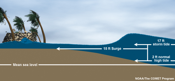
Before we look at those historical hurricanes, let's touch base on the basics of storm surge and coastal flooding. A storm surge is an abnormal rise in saltwater at the coast caused by low air pressure and strong onshore winds in severe storms.
The image below shows how storm surge and waves can inundate an area and push far inland. (Image: NOAA/ The Comet Program).

Water strikes objects with more force than wind, so as you can imagine, buildings quickly collapse under incessant pounding of sea water. In more severe cases, buildings can be gutted or washed away without a trace.
Consider the two pictures below that I took last October in Mexico Beach, Florida. I took these photos in exactly the same location (my feet are in the same position looking in the same direction). I took picture #1 on Tuesday morning and picture #2 on Saturday morning. In between these two photos, Hurricane Michael blasted Mexico Beach with a 15-foot storm surge that gutted coastal buildings.

"Before" picture in El Governor Hotel, Mexico Beach, FL. Tue Oct 9, 2018. Photo: Hal Needham

"After" picture in El Governor Hotel, Mexico Beach, FL. Sat Oct 13, 2018. Photo: Hal Needham
My post-storm view from the south-facing stairwell in the same building showed chewed-up roadway and concrete slabs where large houses stood just a few days earlier.

Another view of Mexico Beach, Florida, shows slabs where large homes once stood. Testimony to the power of storm surge. Photo taken October 13, 2018 by Hal Needham.
We often think of hurricanes as wind events, in part because it's difficult to document the destructive force of storm surges and live to tell the story! In reality, flooding from storm surge and heavy rain are responsible for 88% of deaths in hurricanes and tropical storms (Erdman 2019).
Initially, Dorian is forecast to approach Florida's coast as a slow-moving, category-4 hurricane. The slow movement will prolong the storm surge flooding, enable saltwater to push far inland, and give angry waves more time to erode sand dunes and other coastal protection.
HISTORICAL STORMS FOR REFERENCE
A few historical storms provide context for Dorian's storm surge potential. Let's look at two major (cat 3+) hurricanes that both impacted Palm Beach County...the 1947 hurricane and Hurricane Jeanne in 2004.
THE 1947 HURRICANE
The 1947 made landfall as a category-4 hurricane with maximum sustained winds of 132 mph (115 knots). The storm tracked to the west-southwest upon approach and made landfall between Pompano Beach and Hollywood.

Track of the 1947 Hurricane, courtesy NOAA.
This storm generated an 11-foot storm surge at Hillsboro Lighthouse, Boynton Beach and Palm Beach (Barnes 1998). This means the saltwater rose to 11 feet higher than it would have been had there not been a hurricane.
This is the highest storm surge level on record in Palm Beach County. Dig deeper into this local flood history at the Palm Beach County U-Surge Page that I just launched this morning.
The photo below depicts damage from this storm to the Seacrest Hotel in Delray Beach. Note the effect of scouring from the storm surge and powerful waves.

The 1947 hurricane was not only a powerful hurricane, but also geographically large. This large wind field enabled the hurricane to generate a high and extensive storm surge.
The Monthly Weather Review from 1947 reads, "Winds of 100 m.p.h. or over were experienced generally along the Florida east coast from the northern portion of Miami to well north of Palm Beach, a distance of about 70 miles, while winds of hurricane force prevailed from approximately Cape Canaveral to Carysfort Reef Light, a distance of about 240 miles."
I created the map below to show the track of this hurricane, as well as the swath of peak storm surge levels, shown on the map in orange, reaching from 8-12 feet (peak surge was 11 feet).

HURRICANE JEANNE (2004)
Hurricane Jeanne approached the Florida coast as a category-3 hurricane with maximum winds of 121 mph (105 knots). The storm made landfall north of Palm Beach, near Port St. Lucie.
Not only was Jeanne less powerful than the 1947 hurricane, but the wind field was considerably smaller. Whereas the diameter of hurricane-force winds reached 240 miles in the 1947 Hurricane, they only reached 138 miles (120 nautical miles) in Hurricane Jeanne (Demuth et. al 2006).
Lawrence and Cobb (2005) comment on Jeanne's relatively small size by stating, "Maximum winds at landfall are estimated at 105 kt [121 mph] over a very small area north of the center and it is not clear whether these strongest winds reached the coast or remained over water."
As expected, Jeanne's storm surge levels were considerably lower, reaching an estimated six feet from Melbourne to Ft. Pierce (Lawrence and Cobb 2005). The map below show's Jeanne's track and storm surge observations.

So what do these storms tell us about the storm surge potential for Hurricane Dorian? Well, we have a few clues...
The latest NHC advisory only provides wind field size forecasts for 74-mph wind out to Sun Sep 1 at 200AM EDT and landfall may occur as late as Tuesday morning. The forecast predicts Dorian to have an unusually small area of hurricane-force winds for such a powerful storm, only reaching to 46 miles (40 nm) by early Sunday morning. However, it should be on a trend of an expanding the wind field at that time. Even if the wind field doubled by early Tuesday morning, it would still only reach 92 miles (80 nm).
The table below compares wind speed and the area of hurricane-force wind speed for these storms.

Note that storm surge prediction is complex and depends on many factors, including coastal shape, profile and offshore water depth. Generally speaking, the farther north we travel along Florida's East Coast, the higher the storm surge potential.
That said, the world needs a "back of the envelope" storm surge estimate right now...something to give general guidance. So I'm going to step out and make a prediction for a peak surge of 8-10 feet based on the best available data right now.
Keep in mind this is water depth above Normal Astronomical Tides (NAT). We are just coming down from a king tide cycle, so water levels in most communities should already be elevated well above Mean Sea Level (MSL) at time of high tide.
Consider the tide forecast at Trident Pier in Port Canaveral (see graph below). High tide is forecast to reach 2.47 feet above MSL on Monday night around 11PM. This prediction is based on the Earth- Moon relationship and does not account for impacts from Hurricane Dorian. A storm surge level of 7.53 feet would push salt water to 10 feet above MSL at this site.

Tide forecast for Trident Pier in Port Canaveral shows a forecast high tide of 2.47 feet above Mean Sea Level (MSL) on Monday night.
Please keep the following in mind:
1) This forecast could change substantially given changes in Dorian's the track, intensity and size.
2) Even if this forecast is right on the money, it only tells a small part of the story. If Dorian was moving through quickly and exiting the stage door 12 hours after landfall, this storm would be easier to comprehend. But latest model runs show Dorian slowing down considerably and tracking north along the Peninsula.
This creates the following high-impact angles to Dorian's flood story:
EXTENSIVE COASTAL FLOODING AND EROSION
If Dorian does track north up the Florida Peninsula, the potential for extensive coastal flooding and erosion along the entire Florida coastline north of Palm Beach increases substantially.
The latest Euro model run below shows the potential for hurricane-force winds to move up the coast even as Dorian's eye could track inland. A slow-moving hurricane taking this path could generate an extensive coastal flood event with massive erosion and property losses.

COMPOUND FLOOD EVENT
A slow-moving hurricane or tropical storm greatly increases the risk of compound flooding from both storm surge and heavy rain.
The latest GFS precipitation forecast, copied below, shows the potential for 14 or more inches of rain over an extensive area from South Florida through South Carolina.

Prolonged saltwater inundation will oppose, and effectively "dam" fresh water runoff, preventing this rain from draining to the coast. So when it rains 18" in an urban area next week, where is that rain going to drain to when saltwater is vigorously pushing inland?
It is becoming more likely that places that have never flooded before could experience deep inundation. Seven years ago this week, Hurricane Isaac's (2012) compound surge/ rain flooding inundated parts of southeast Louisiana that did not flood in Hurricane Katrina. The picture below shows the inundation in Laplace, Louisiana.

Inundation in Laplace, Louisiana, from Hurricane Isaac (2012).
The ironic fact about compound flooding is that the worst impacts and greatest loss to life and property often happen after the storm has made landfall and the category has been "downgraded".
Compound floods are long-duration events and humans cannot process long time frames well. We've watched too many movies when all the action happens in a quick explosion. It's much harder for us to comprehend that our flood threat is just beginning after the news says a storm has been downgraded or weakened.
LONG-DURATION FLOOD EVENT
Hurricane Dorian threatens to generate a long-duration flood event, which will exacerbate impacts. A long-duration coastal flood event enables saltwater to push farther inland. A longer-duration rain and wind event will bring down many more trees.
I observed a lot of tree falls last year from Hurricane Florence in North Carolina. When I talked to locals about the storm impacts, many people told me they thought the long-duration of the wind and rain enabled Florence to bring down so many trees, because the soil gave way after days of inundation. See pic below.

Wilmington, NC observed massive tree falls in Hurricane Florence last September because of the long-duration of strong winds blowing on trees in wet soil. Photo: Hal Needham
SECOND FLOOD "HOT" SPOT
The concaved-shaped coastline from northeast Florida through southwest South Carolina, including the entire Georgia Coast, is a "hot spot" for coastal flooding. The shape of the coastline and the shallow offshore water depth effectively enhance salt water floods if a hurricane is centered just off the northeast Florida coast or even located over the Peninsula.
Georgia has a brutal history of saltwater floods that struck in the late 1800s. The photo below, from the 1898 hurricane, shows widespread destruction at Brunswick, where a 16-foot storm surge slammed the coast. This storm also produced an 18-foot storm tide at Sapels Lighthouse and killed 179 people.

For more reading, see my blog post from October 7, 2016, "The Protected Coast is Now the Most Dangerous Place of All..."
Hurricane Irma's (2017) storm surge map shows how efficient this area is for generating storm surge. Along the east coast, tide gauges near the Florida/ Georgia border observed the highest water levels, as seen on the U-Surge storm surge map below. This surprised many people who expected the highest surge on Florida's east coast to be closer to Miami.

U-Surge map of Hurricane Irma's storm surge flooding. Note the localized maximum near the Florida/ Georgia border.
The latest Euro model run shows Dorian tracking just inland up the Florida Peninsula and then following the coastline along Georgia and South Carolina. The model run shows the wind field increasing in size dramatically compared to the initial landfall in southeast Florida.

Euro model for Thursday evening, forecasts Dorian to be centered along the coast near the Georgia/ South Carolina border with an increasing wind field.
If this forecast comes close to verifying, places like Jacksonville, Savannah (Tybee Island), Hilton Head and Charleston could observe substantial flooding, especially if the wind field increases in area.
Long story short, we are potentially looking at a multi-dimensional, long-term flood event that includes:
1) An initial storm surge in southeast or central Florida;
2) Extensive coastal flooding and erosion along most of Florida's East Coast;
3) Severe compound flooding that inundates areas with deep water that have never flooded on record;
4) A potential second coastal flood hotspot from St. Augustine/ Jacksonville through Charleston, including all of coastal Georgia.
Thursday, August 29, 2019
Dorian Eyes Florida and Forecast Slowdown after Landfall May Increase Flood Risk
BIG PICTURE
Hurricane Dorian should intensify today and tomorrow and become a major hurricane (cat 3) on Friday. Dorian is expected to make a westward turn on Friday and Saturday, and approach the Florida Coast late in the weekend or early next week. Considerable uncertainty in the track remains, and the entire Florida Peninsula is still in the "cone of uncertainty". A stronger version of Dorian could track farther to the south and a slightly weaker version track farther north. Regardless of the exact landfall location, Dorian could inflict severe wind and storm surge impacts related to landfall, and then possibly prolonged flood impacts north to Georgia and the Carolinas next week.

IN DETAIL
It helps to think of Dorian's development and impacts in four distinct phases:
PHASE NAME TIMING
PHASE I INTENSIFICATION THU PM - FRI
PHASE II TURNING FRI - SAT
PHASE III COASTAL IMPACTS SUN - TUE
PHASE IV PROLONGED FLOODING TUE - THU
PHASE I: INTENSIFICATION
THU PM - FRI
Dorian's maximum sustained have held at 85mph for the past 12 hours. Some moderate wind shear associated with an upper level low to the west has been impeding Dorian from intensifying. This upper level low should back off later on Thursday, enabling Dorian to strengthen. The National Hurricane Center forecasts maximum sustained winds will increase to 100mph by this evening.
Dorian should then track through a very favorable environment for intensification, as low wind shear, warm sea surface temperatures and a moist environment enable Dorian to likely become a major hurricane (cat 3) on Friday.
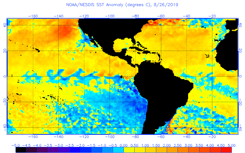
The sea surface temperatures along Dorian's entire forecast path are consistently running warmer than normal. The map above from NOAA/ NESDIS shows the massive extent of warm sea surface temperatures throughout the entire Main Development Region (MDR) of the western North Atlantic basin. These warm waters play a role in Dorian's intensification because they provide the fuel hurricanes need to develop.
An upper level ridge should start building to the north or northeast of Dorian and encourage a turn towards the west on Friday and Saturday.
While the timing, position and strength of this ridge are somewhat uncertain, hurricane climatology reveals an important pattern for such situations. In general, a more powerful hurricane will "feel" the ridge earlier than a weaker hurricane, meaning if Dorian develops into a more powerful hurricane (cat 3-4) by Friday afternoon, it may make a sharper turn to the west than a weaker (cat 2-3) version of the same storm.

A stronger version of Hurricane Dorian would likely "feel" the steering of the upper level high pressure system sooner, giving the storm a track farther south.
This may explain, at least in part, the difference in landfall pressures between the latest runs of the American (GFS) and European models. This morning's GFS model showed an air pressure of 968 mb around the time of landfall, whereas yesterday evening's European model forecast a landfall pressure of around 959 mb, which may indicate a slightly stronger storm.

This morning's American (GFS) model run depicts a powerful hurricane with 968 mb central pressure approaching the central Florida coastline.

PHASE III: WIND/ SURGE IMPACTS
Dorian will likely inflict severe wind and flood impacts along the southeast U.S. Coastline. Although Florida may be the prime target right now, flood and wind impacts could extend into Georgia and South Carolina.
Initially, it looks most likely that Dorian will make landfall somewhere on the Florida peninsula. The late morning (11AM EDT) advisory from the National Hurricane Center indicates that that most likely track would take Dorian to near the Central Florida Coast by Monday morning, and wind speed estimates have bumped up to 130 mph, which would make Dorian a powerful cat-3 hurricane, approaching the cat-4 threshold.

I ran some historic storm surge maps this morning to look for guidance from analog/ historic hurricanes that have approached Florida's Atlantic Coast. Considering Dorian's forecast in light of historic observations, the best general guidance I could come up with, based on the current track and intensity forecast, is a storm surge level of 11-13 feet.
I think it's likely for a more powerful version of Dorian to track farther south, but coastal dynamics in southeast Florida are not as conducive for storm surge development as northeast Florida. Therefore, a category 3 hurricane making landfall in northeast Florida, may generate comparable, or slightly higher, storm surge levels than a category 4 hurricane striking southeast Florida.

The coastal profile of northeast Florida, Georgia and South Carolina enhance storm surge levels in this region. Comparable hurricanes will generate higher storm surge in northeast Florida than southeast Florida.
If we look closely at the NHC advisory, we see an interesting detail that has emerged. Look at the reduced forward motion after landfall on this advisory. According to the map, Dorian would make landfall late morning on Monday and the center of circulation would be near Orlando at 8AM Tuesday.
We should not focus on specific locations and timing at this point, but use this insight to see the bigger picture. The NHC forecast is hitting on something also seen in the American and Euro models- it appears that Dorian will slow down dramatically, and make a turn towards the north or northwest around or after landfall.
Given the high uncertainty in the forecast at this time, it is also possible that this turn could happen before landfall, taking Dorian on a track towards Georgia or South Carolina. Although it is too early to know these details, all interests from South Florida through South Carolina should prepare for potential severe wind and flood impacts.

I have increased the likelihood of substantial damage from wind and flood impacts for all three hazards on the Hazard Area Likelihood (HAL) Index today. Substantial wind and flood impacts are now probable for all hazards.
The trend for Dorian to slow down dramatically early next week is of great interest, and heightens the drama of this storm. If the slow down or stall happens around or after the time of landfall, it will greatly exacerbate flooding from both storm surge and rainfall....whereas if it occurs before landfall, it could possibly keep Dorian offshore and diminish flood risk.
Wednesday, August 28, 2019
Hurricane Dorian Threatens A Stretch of Florida Coast that Has Been "Lucky" For Decades
BIG PICTURE
IN DETAIL

 The National Hurricane Center forecasts Dorian to approach the U.S. coastline as a major hurricane later this weekend and Labor Day.
 Since records began in 1851, no major (cat 3+) hurricanes have made direct landfall south of St. Augustine and north of Port St. Lucie, Florida. Base map: NOAA Historical Hurricane Tracks Tool.
 Debris from Hurricane Matthew in 2016. Although the storm did not make landfall in Florida, it tracked close enough to the coastline to inflict severe flood and erosion damage from storm surge and massive waves.
The updated Hazard Area Likelihood (HAL) Index for Hurricane Dorian, forecasts the likelihood of substantial impacts from wind and storm surge as PROBABLE (orange) and impacts from heavy rain as POSSIBLE (yellow).
 The Hazard Area Likelihood (HAL) Index now forecasts the likelihood of substantial impacts from wind and storm surge as probable, and from heavy rain as possible.
Hurricane Dorian has survived its trek through the mountainous Caribbean Islands and now threatens to bring major wind and storm surge impacts to the Bahamas and U.S. mainland. It threatens to strike a stretch of Florida Coast that has been "lucky" for decades, and could inflict substantial storm surge flooding from South Florida through South Carolina, depending on the exact track.
Dorian strengthened into a hurricane this afternoon, as it tracked near the U.S. and British Virgin Islands, east of Puerto Rico. The system should enter a more favorable development for intensification over the next several days, as it passes over warm ocean water, in a moist environment with relatively low wind shear.
Infrared satellite imagery on Tue Aug 28 shows explosive growth in Hurricane Dorian over the northeastern Caribbean Sea.
Some uncertainty in the track still remains, but the National Hurricane Center forecasts the northwest track to turn more towards the west beginning Friday, as a building ridge over the Atlantic guides the storm closer to the U.S. coast.
Given the favorable environment for development, Dorian is now forecast to become a major hurricane and then track over or north of the Bahamas. The entire Atlantic Coast of Florida is still in the "cone of uncertainty" but this range of landfall locations should become smaller in upcoming forecasts.
The National Hurricane Center's best-track forecast right now is for Dorian to strike the central Florida coast as a major (wind category 3+) hurricane. If this forecast verifies, Dorian would fill in a "gap" in Florida's hurricane climatology, as climate records since 1851 provide no major hurricanes that made direct landfall on Florida's Atlantic Coast south of St. Augustine and north of Port St. Lucie. This includes the entire Space Coast region and Daytona Beach area.
The map above shows all major hurricanes that tracked within 100 nautical miles of Titusville, on the Space Coast. Since 1851, 10 hurricanes have met this criteria. Of these storms, five made direct landfall on the Atlantic Coast. Hurricane Dora (1964) struck in the northern part of the circle, near St. Augustine, and then a cluster of four hurricanes struck from around Delray Beach through Port St. Lucie. Hurricane Jeanne (2004) is the farthest north of these four clustered storms.
More recently, the eye of Hurricane Matthew (2016) tracked parallel to the coast. Although the eye remained offshore, and did not make a Florida landfall, the storm's angry waves and storm surge ate away at the coastline and plunged numerous houses into the ocean. A direct strike from a major hurricane would inflict more severe impacts than that.
The updated Hazard Area Likelihood (HAL) Index for Hurricane Dorian, forecasts the likelihood of substantial impacts from wind and storm surge as PROBABLE (orange) and impacts from heavy rain as POSSIBLE (yellow).

In the upcoming days, I will update my blog regularly with the latest forecasts. I will also provide history about past flood events in the region and how Dorian may compare to hurricanes like Dora (1964), Jeanne (2004) and Matthew (2016).
I will especially provide insights into storm surge flood potential. Keep in mind that the stretch of coastline from northeast Florida through South Carolina, including the entire coastline of Georgia, very efficiently enhances storm surge flooding, and this entire region could experience storm surge flooding even if Dorian makes landfall on the Central Florida coast.
As Dorian is still centered in the Caribbean, noticeable shifts in the storm's track can be expected. All interests from extreme South Florida and the Florida Keys, through South Carolina, including all of Georgia and eastern Florida, should monitor trusted news and weather sources in the upcoming days.
Wednesday, May 29, 2019
Seven Lessons Learned from the 2018 Hurricane Season
With the start of the 2019 Hurricane Season right around the
corner, I thought I would go back and share seven lessons I learned from the 2018
Hurricane Season.
Last year I personally did my most in-depth hurricane field work to date, spending a few weeks on the ground in the areas impacted by Hurricane Florence and Hurricane Michael. I was in both areas before, during and after the storm struck. Here’s what I learned:
Last year I personally did my most in-depth hurricane field work to date, spending a few weeks on the ground in the areas impacted by Hurricane Florence and Hurricane Michael. I was in both areas before, during and after the storm struck. Here’s what I learned:
1) Construction Type Matters
I spent time in Panama City in the days after Hurricane Michael's landfall. The
area looked like a nuclear bomb exploded.
You didn't have to be a construction scientist to see the difference in roof performance in areas like 17th Street. While most of the metal roofs in this region remained intact, wooden roofs were
substantially damaged or gone.

Metal roofs generally fared better than wooden roofs around 17th Street in Panama City during Hurricane Michael. Photo: Hal Needham

A family in the disaster zone took me up on their metal roof
and explained how well it fared. A tree branch did pierce it, creating a hole,
but they were able to quickly patch it and lived in the house.
This story gave me new insight. I learned that if your house
did not flood and you had a roof intact, you could live at home, even if your
property sustained substantial damage.

A family invited me to see their roof following Hurricane Michael. I'm standing on the left. Photo: Hal Needham

This family told me they just put on a new roof the year before. They chose to spend a little more money on a better roof and that decision helped them immensely when Hurricane Michael struck.
Of course, there are no guarantees in hurricanes. Metal
roofs sometimes fail and some wooden roofs fare better than others. This is
just an observation I made from spending time in a few neighborhoods that
sustained category-4 winds of around 140 – 145 mph.
2) Evacuation Direction Matters
I spoke to several people who evacuated from Hurricane Michael by moving inland and slightly to the east. While this decision removed them from proximity to saltwater storm surge, in some cases it placed them in more dangerous winds.
One woman left a neighborhood in Panama City Beach that observed category-3 winds and evacuated to Parker, a community to the east that observed upper category-4 winds and experienced catastrophic damage. In retrospect, she thought that decision could have cost her life.
By contrast, families who evacuated west, or who went farther inland, fared better. Hurricane forecast models consistently predicted Hurricane Michael would curve to the northeast before landfall.
For example, people who evacuated one hour west to Destin, Florida, were happy with their decision, found little traffic and were able to make it back home quite quickly.

Satellite image of Hurricane Michael, with an arrow showing the path of people I talked to who evacuated to the west. These people fared better than those who did not evacuate or who evacuated east. Of course, evacuating inland is usually the safest decision.
We must keep in mind, however, that uncertainty still exists in hurricane forecast modeling, and coastal residents should not make decisions on a "pinpoint" forecast, but rather consider the entire cone of uncertainty when forecasts are issued. Of course, evacuating inland is the safest bet when leaving a hurricane hazard zone.
3) Keep A Battery-Powered Radio Handy
I spoke with a pastor in Panama City who was using his church as a base for receiving and sending hurricane relief supplies. I asked him to share the biggest lesson he learned from Hurricane Michael. He said, "I wish I had a battery powered radio. I can't believe I didn't think of that because I'm usually prepared. But in the days after Michael cell phones did not work and it was hard to get information."
A radio station in the disaster zone was sharing crucial information in the days following the storm, such as where to receive food and water, where and when curfew existed, how to apply for disaster assistance, etc. A battery-powered radio can be a lifeline to the world following a disaster!
4) Prolonged Wind and Rain Leads to More Downed Trees...Even in Tropical Storms
Hurricane Florence made landfall near Wrightsville Beach, North Carolina. In the following days, Florence was downgraded to a tropical storm and slowly drifted to the southwest, not far from the South Carolina border.
The storm generated tropical storm force winds and dumped copious amounts of rain on eastern North Carolina in the days following landfall.
Many neighborhoods in Wilmington experienced dozens of tree falls. This surprised many people because Florence never generated hurricane-force winds in Wilmington. In fact, the highest sustained (2-min) wind speed observed in Wilmington was 57 mph, with a gust to 91 mph, keeping Wilmington well within the zone of tropical storm force sustained winds, which range from 39 to 73 mph.

Photo of a massive tree that fell from Tropical Storm Florence in Wilmington, North Carolina. Photo: Hal Needham
However, Florence taught us a valuable lesson. A tropical storm generating winds of 50-60 mph is still able to down many trees when strong winds are blowing for multiple days and the trees are rooted in saturated soil.
5) Strong Communities Come Together and Open Accessibility Faster
The fifth lesson I learned last year is that strong communities come together and open accessibility faster. I came across a street in Panama City that was surprisingly open two days after Hurricane Michael struck. While other neighborhoods were choked with fallen trees, the streets in this community were already open.
As I made my way down this street I discovered why. Locals had come together and shared resources, like gas containers, jeeps and chain saws. Young and old worked together to clear their street, instead of waiting for the government to come and remove the debris.


I saw this same spirit of community engagement in Texas during Hurricane Harvey (2017) and in the several years I lived in Alaska. If an ice storm hits Interior Alaska and trees are across the roads, locals are going to work together to clear it right away instead of waiting for outside assistance.
These neighborhoods open up quicker and also experience the benefit of bonding from working together as a community.
6) Many People are Only Familiar With Their Own Hurricane History
I was surprised that more people were not evacuating the day before Hurricane Florence struck the Carolinas. I arrived in North Myrtle Beach, South Carolina, miles from the North Carolina border, to find that many people decided to ride the storm out because the category number dropped.
At the time, Florence was forecast to slowly drift near the coast of the Carolinas and dump tremendous rainfall. The biggest danger was from the water not the wind. The Saffir-Simpson Hurricane Wind Scale does not indicate danger from flood, it is based entirely on maximum sustained wind velocity, so a lower-category storm does not mean flood risk has reduced.
Other locals said they were not going to leave because they fared well in Hurricane Hugo (1989). Hugo was a vicious category-4 hurricane that made landfall right in the heart of South Carolina, but Florence was no Hugo. While Florence made landfall as a category-1 hurricane, the real threat from this storm was flooding from days of torrential rain as the storm drifted.

Flooded streets in Fair Bluff, North Carolina, following days of torrential rain from Tropical Storm Florence. Parts of North Carolina observed more than 30 inches of rain. Photo: Hal Needham
I told locals that this storm is not like Hugo, but more like Harvey (2017). They just looked at me with a blank stare, as if to ask, "What's Harvey?"
Hurricane Harvey stalled along the Texas Coast in 2017 and dumped more than 50 inches of rain in parts of metro Houston and the Beaumont-Port Arthur area. The storm led to $125 billion dollars in losses. I was living in nearby Galveston when Harvey struck, but I thought Harvey made the entire country aware of the danger from a stalled-out tropical system.
It had not.
I learned a lesson while on the ground in the day before Florence. People know their own hurricane history, but may not know valuable lessons taught to other cities, no matter how devastating.
7) Hurricanes Winds Can Be Strong Enough to Blow Over a Train
The seventh lesson I learned last year has to do with the power of hurricane winds. I never had seen such catastrophic wind damage as I saw in the days following Hurricane Michael.
A portion of an apartment complex, around eight or nine stories in air, was ripped out and I found slabs of the wall more than one block away. Nearby cars looked bombed out from debris strikes.
But the most lasting vision in my mind is the train that blew over from Michael's category-4 winds in the eastern part of Panama City. Michael was able to blow many cars of this train off the track, and wheels were still suspended in the air days after the storm.


Hurricane Michael's category-4 winds (in this location) blew this train off the tracks in the eastern part of Panama City, Florida. Photo: Hal Needham
Nearby, I came across several cars that look flattened. Their damage was not consistent with other cars in this part of the city. Then I saw a damaged shipping container angled into the highway and a SUV perched off the edge of a retaining wall.
Putting the pieces together, it appears that Michael flipped or rolled this shipping container through a parking lot, flattening or pushing many vehicles. In this area of the city, maximum sustained winds were estimated at category-4...probably sustained in the 140 mph range.
2019 Hurricane Season Fast Approaching
The 2019 Hurricane Season is fast approaching, as it officially begins this Saturday, June 1. In the upcoming weeks, I will be doing a series of blogs related to coastal flood and wind risk, and looking at the upcoming hurricane season.
Subscribe to:
Posts (Atom)