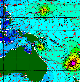
The tropics continue to threaten high storm surge potential as four active tropical cyclones spin in the Pacific and Indian Oceans. The cyclones are
Severe Tropical Cyclone Pam, which is approaching the Island Nation of Vanuatu,
Severe Tropical Cyclone Olwyn, which made landfall in Western Australia and is
currently tracking from north to south along the coastline, TC Nathan, which is
nearly stationary off the coast of Queensland, and Tropical Storm Bavi, which
is in the Northern Hemisphere, and forecast to track on the north side of
Micronesia.

Four active tropical cyclones are visible in this
atmospheric circulation map provided by the Earth Wind Map project.
Link: http://earth.nullschool.net/.
Link: http://earth.nullschool.net/.
Severe Tropical Cyclone Pam threatens to inflict the most severe damage, as this category-5 tropical cyclone bears down on Vanuatu. On
Mar 12 at 1800Z, the Joint Typhoon Warning Center (JTWC) estimated Pam’s
intensity at 140 kts (259 kph, 161mph), which essentially classifies Pam as a
category-5 cyclone in any rating system around the world. Pam is also a large
cyclone, which gives greater potential for damaging winds and storm surge
generation. Unfortunately, Pam continues to track slightly west of south, and
has not yet begun a curve to the south and southeast, which means Pam is
tracking perilously close to Vanuatu’s southern islands, and may make a direct
landfall.

NOAA’s visible satellite image shows TC
Pam approaching Vanuatu.
Source: http://www.ssd.noaa.gov/PS/TROP/floaters/17P/flash-vis-long.html
The JTWC estimates Pam’s maximum significant wave height at
13 m (44 ft). Significant wave height is the mean height of the highest
one-third of the waves. NOAA’s WAVEWATCH 3 (WW3) ocean modeling predicts
similar significant wave heights, with heights building to at least 15 m (50
ft) after Pam passes south of Vanuatu.
NOAA’s WAVEWATCH3 forecasts significant wave heights, swell heights, wave periods, wind speed and
direction.
Storm surge forecasts are not provided for
Vanuatu or Fiji, however, Vanuatu Meteorological Services forecasts “phenomenal
seas” exceeding 10 m (33 ft) through Sunday. In my previous post, I uploaded photos of storm surge flooding in Tuvalu, approximately 700 miles (1125 km)
northeast of Pam. As this storm surge was generated when Pam was less developed, we can only imagine the
terrific waves and surge that will pound the coasts of Vanuatu and Fiji during
the next 24 hours.
Severe Tropical Cyclone Olwyn made landfall near Exmouth,
Western Australia, as a category-3 tropical cyclone, and then took a sight
seeing tour as it tracked along the coastline, maintaining category-3 status.
As of 11:00AM WST, Olwyn’s maximum sustained winds were 150 kph (93 mph). This
intensity would be a strong category-1 hurricane in the Atlantic.

Severe TC Olywn made landfall in
W. Australia near Exmouth, then tracked
south along the coast towards Carnarvon.
Source: http://www.bom.gov.au/products/IDW60281.shtml
Tide gauge data from Western Australia's Department of Transport indicated a 1.75-m (5.7 ft) storm surge at Exmouth, and a storm tide level (tide + storm surge) of nearly 3.5 m (11.5). Higher water levels may be observed near Shark Bay, where the bay should trap the surge and
enhance water levels.

Tide gauge data from Exmouth reveals a 1.75-m storm surge (green line) and a storm tide level (storm surge + tide) of nearly 3.5 m (yellow line). Source: http://www.transport.wa.gov.au/imarine/exmouth-storm-surge.asp
As Olwyn tracks south along the coast, it may generate a 0.5- 1.0 m (1.6-3.3 ft) shelf wave along the entire southwest coast, according to Andrew Burton, Regional Forecasting Centre Operations Manager at the Australia Bureau of Meteorology, Western Australia Region. Shelf waves tend to form when cyclones travel parallel to a coastline and trap high water near the coast, such as during Hurricane Dennis when it tracked along Florida's West Coast in 2005. Olwyn's shelf wave may help elevate water levels at many locations above the level of Highest Astronomical
Tide (HAT).
Tropical Cyclone Nathan decided to pay Queensland a visit,
but then got a bit indecisive north of Cape Flattery, as it made a sharp turn
to the north before reaching the coast. Nathan is a category-2 tropical
cyclone, but is forecast to intensify to a category-3 cyclone as it moves back
to the east. Australia’s Bureau of Meteorology predicts that abnormally high
tides could develop between Coen and Cape Flattery today, possibly leading to
minor coastal flooding along the foreshore.

Tropical Cyclone Nathan approached the Queensland Coast, north of Cape Flattery, before making an abrupt turn towards the north. Source: http://www.bom.gov.au/products/IDQ65002.shtml.
I'm sure Tropical Storm Bavi is up to something interesting too, but I'll have to save that for another day. It's not very often that four active tropical cyclones are spinning at the same time! Take care, everyone, and stay safe!
No comments:
Post a Comment