Sunday, October 8, 2017

Nate's Storm Surge Exceeds 6 ft in SE Mississippi


Hurricane Nate's storm surge has exceeded 6 ft in SE Mississippi, according to a NOAA tide gauge at Pascagoula. Video footage on social media depicts multiple feet of storm surge inundating casinos in Biloxi.

Other tide gauges in the region reported maximum storm surge levels reaching 4-6 feet, including Shell Beach, Louisiana, Bay Waveland Yacht Club, Mississippi, and Mobile State Docks along the Mobile, Alabama, waterfront.

Nate made landfall as a category-1 hurricane twice. The first landfall occurred in southeast Louisiana, near the mouth of the Mississippi River, and the second landfall occurred near Biloxi, Mississippi. The 400AM Central Time advisory from the National Hurricane Center downgrades Nate to a tropical storm, but beware of continued strong squalls to the east of the center of circulation.

Storm surge levels should drop through the morning along the northern Gulf Coast.


Saturday, October 7, 2017

Hurricane Nate Storm Surge Update


As of 900PM Central Time, Hurricane Nate has generated a widespread 2-4 ft storm surge along the Gulf Coast. Peak surge levels have now exceeded 4 ft at Shell Beach, Louisiana, and continue to rise in this location.

Expect maximum storm surge levels to reach 4-7 ft east of the Mississippi River in SE Louisiana, as well as the Mississippi Coast.

These storm surge levels do NOT include normal astronomical tides, which are peaking this weekend in the region due to the full moon. These king tides are among the highest tides of the year, and are not included in these storm surge observations.

Therefore, give a buffer for additional flooding because tides would normally be unusually high even if there wasn't a hurricane in the Gulf.


NHC Wildly Over-predicts Nate's Storm Surge Potential

As Hurricane Nate races towards the northern Gulf Coast, the National Hurricane Center's (NHC) 1PM (Central Time) advisory predicts maximum storm surge levels to reach 7-11 feet from the Mouth of the Mississippi River east to the Mississippi/ Alabama border, 6-9 feet along the Alabama Coast, and 4-6 feet for the Western Florida Panhandle, including Pensacola, as well as the area west of the Mississippi River, to Morgan City, Louisiana.

Visible satellite image of Hurricane Nate as of 11:15AM Central Time on Sat Oct 7, 2017


Although Nate is forecast to make landfall as a category-2 hurricane, these estimates are wildly over-estimated for several reasons:

1) Nate is RACING to the coast at an incredible 25 mph. This is more than twice the forward speed at which hurricanes typically approach the coast in this part of the world. Strong onshore winds need ample time to push water towards the coast, and Nate's rapid forward speed means it will make landfall before it has the chance to generate a substantial storm surge.

2) Nate is strengthening as it approaches the coast. I was lead author on a paper published three years ago that found storm surge correlates better with pre-landfall wind speeds than wind speeds at landfall, with the optimal correlation occurring 18 hours before landfall. So even if Nate makes landfall as a category-2 hurricane, 18 hours before landfall wind speeds were around 80-85 mph, making it an "average" category-1 hurricane when the time was most important for storm surge generation.

3) Nate's wind field is small. As of the 1PM Central Time advisory, hurricane-force winds extended only 35 miles from the center of circulation and tropical storm force winds extended 125 miles (see graphic below). 

Nate's small wind field will keep it from generating a massive storm surge. This graphic from the NHC depicts hurricane-force winds as red and tropical storm force winds as light orange, as of 10AM Central Time on Sat Oct 7.


Compare that with Hurricane Ike (2008), which approached the Upper Texas Coast as a high-end category-2 hurricane with hurricane-force winds extending 120 miles and tropical storm force winds extending 275 miles from the center of circulation, enabling Ike to generate a massive storm surge.

4) Nate's wind field has consistently been asymmetric, or offset, during it's journey through the Yucatan Channel and into the Southern Gulf of Mexico. Strongest winds have been offset to the east of the center. Given the predicted track, maximum sustained winds should stay east of the Louisiana Delta, and I cannot understand the rational for predicting 4-6 feet of storm surge west of the Mississippi River. The Mississippi River Delta does a good job of protecting points west, like Grand Isle and Morgan City, from storm surge even in a well-organized system- it is very unlikely that Nate will generate a storm surge higher than 3 ft in these areas.

Marine Weather and Climate runs the U-Surge project, which essentially serves as the U.S. storm surge database. I have personally been constructing storm surge databases for the past 10 years, and, based on that work, I would like to offer a storm surge forecast of my own, from a data-driven perspective.

Here is a comparison of my Marine Weather and Climate storm surge forecast compared to the NHC forecast, from west to east:


Much thanks to the NHC for their hard work and for rolling out improved products in recent years. I like what they do and value their work.

I believe in the power of having multiple voices/ forecasts as a big storm approaches. This helps the public discern levels of certainty for a given hazard, like rainfall, wind or storm surge. If all forecasters provide the same message, certainty is higher than if different messages are heard.

I realize I will probably get my "hand slapped" for publicly disagreeing with the NHC on Nate's storm surge potential. In the days leading up to Harvey I got my hand slapped for not sticking with "one consistent message" when I published a blog post titled, "Harvey's Compound Rain/ Surge Flooding Could be Catastrophic and Underestimated- Especially along the Houston-Galveston Corridor", 36 hours before all hell broke loose in Houston.

However, Harvey was unbelievably catastrophic in my neck of the woods, and I have no regrets whatsoever for speaking my mind. For every hate message, I received hundreds of messages from people thanking me for speaking clearly and truthfully, and many thanking me for helping them make "life-saving decisions". Harvey taught me to speak my mind and not care what people think.

I do realize the NHC errs on the side of over-estimating storm surge potential to encourage people to evacuate and take precautions, but the down side to this is that it lowers public confidence when forecasts are consistently more extreme than the reality on the ground.

I believe the best approach is to predict hazards as accurately as possible and communicate this as clearly as possible with the public. Most people are smart and they will do what is necessary to protect their families and communities when given clear, accurate predictions.

For questions or comments on Nate's storm surge, you can reach me at: hal@marineweatherandclimate.com.

-HH


Tuesday, September 12, 2017

Four Surges in One - Perspective on Irma's Wild Coastal Flooding

Although Hurricane Irma made landfall in the Lower Florida Keys as a category-4 hurricane, the massive storm generated wild coastal flooding patterns throughout the Florida peninsula, Georgia and South Carolina. Here's a recap on Irma's storm surge.


Peak Surge Levels

The map below depicts Irma's peak storm surge levels, with storm surge representing the difference in observed and predicted water levels based on normal astronomical tides. The highest observed storm surge levels exceeded 6 feet in places near the Florida/ Georgia border, like Fernandina Beach and Mayport, while water levels in a wider area from east-central Florida through South Carolina, as well as portions of southwest Florida, observed surge levels exceeding 4 feet.


Map of maximum storm surge data. Map created by Dr. Hal Needham (Marine Weather and Climate/ U-Surge), data provided by NOAA Tides and Currents.


As people are just returning to the worst-hit areas of the Florida Keys and southwest Florida, maximum storm surge areas are still being reported.  The table below provides the mapped data in tabular form.


Storm surge observations for Hurricane Irma
Effective Tue Sep 12 at 06:00AM Eastern Time

Storm Surge (water level above normal astronomical tides)

NOAA Tides and Currents Tide Gauges (preliminary water levels)

Fernandina Beach, FL:      7.75 ft

Mayport, FL:                       6.42 ft
Fort Pulaski, GA:               5.63 ft
Naples, FL:                         5.14 ft

Charleston, SC:                 4.87 ft
Trident Pier, FL:                 4.43 ft
Fort Myers, FL:                  4.25 ft
Virginia Key, FL:                3.91 ft
Key West, FL:                    3.30 ft
Old Port Tampa, FL:          3.17 ft

Springmaid Pier, SC:         3.04 ft
Vaca Key, FL:                     2.76 ft
Cedar Key, FL:                   2.50 ft
​Lake Worth, FL:                 2.23 ft
St. Petersburg, FL:            1.96 ft    


Irma's large size and shore-parallel track through southwest Florida, enabled the storm to generate four distinct storm surge events in different regions. Here's a summary below:


Florida Keys


Irma made landfall at Cudjoe Key, in the Lower Florida Keys, as a category-4 hurricane with maximum sustained winds of 130 mph on Sun Sep 10 at approximately 9:10AM Eastern Time.

NOAA tide gauges to the west (Key West) and east (Vaca Key) Irma remained more-or-less operational throughout the storm's passage, although the gauge at Key West has been reporting data intermittently. Surge levels at both sites increased substantially after Irma's eye passed and winds changed direction. As Irma approached, prolonged winds were blowing from east-to west across the Keys, but winds suddenly reversed from west-to-east after the eye passage. Maximum surge levels at both Key West and Vaca Key remained less than 4 feet.

Storm surge levels are highly localized, particularly in island chains, where two locations just several miles apart border water in different directions. For example, the NOAA tide gauge at Key West is located near the western end of the island, making it most susceptible to storm surge generated by a strong west wind.

 
NOAA's Key West tide gauge is located near the western end of the island, making it most susceptible to strong winds approaching the island from the west.

Based on Irma's track, the highest storm surge levels in the Keys, would have likely occurred near Cudjoe Key, Big Pine Key and Marathon. Initial rumors of a 15-foot storm tide (storm surge + tide) circulating social media remain unverified and were likely exaggerated. However, numerous images of sail boats swept onto the Overseas Highway (Hwy 1) provide evidence of a powerful storm surge that swept through the islands.

While spending time on Monday evening on social media groups focused on connecting locals from the Florida Keys, I noticed that numerous posts suggested a peak storm surge in the range of 5-6 feet at Cudjoe Key. However, this information was still speculative, as evacuees were not allowed back into the region yet and information from the Keys to the outside world was limited, often relying on satellite phones.


Although storm surge levels at Key West remained below 4 ft, the force of water pounding over the seawall was powerful enough to peel the paint off the famous "Southernmost Point" monument. 


Keep in mind that along island chains, storm surge values are extremely localized. Water displaced from a distance can pass between islands, but where a hurricane's eyewall is engaged on an island, surge levels will quickly spike, sometimes reaching levels twice as high as areas just 10-15 miles away.

Authorities are letting residents back into the Lower and Middle Keys today, so we should know more about the wind and storm surge impacts soon.


Video posted by Anthony Paul Davis shows storm surge flooding in Marathon, Florida.


Florida West Coast

Florida's West Coast observed the most unusual storm surge patterns, as Irma moved from south to north, approximately following a shore-parallel track. Due to counterclockwise winds around hurricanes in the Northern Hemisphere, substantial "negative" storm surges, when water is pushed away from the coast, occur when hurricanes take shore-parallel tracks and have a large body of water to the left of their forward path.

This occurs because prolonged winds of increasing intensity blow offshore along the coast, while the storm cannot draw any new water to replace the displaced water because strong winds are blowing offshore.

Numerous images of extensive mudflats emerged on Sunday afternoon in places like Tampa Bay. In some cases, humans were able to rescue marine animals, like dolphins and manatee, that were stranded by the receding water.

Marine animals, like manatee, became stranded as Irma pushed water away from Florida's west coast on Sunday, producing negative storm surges. Image: Michael Sechler/ Facebook.

People should use caution in such situations, as rapid changes in wind direction as the eye approaches, can lead to the water rushing back into the bay, along with additional water from an onshore storm surge.

The hydrograph below shows a "negative" storm surge of approximately 5.3 ft was observed at Old Port Tampa on Sunday afternoon, followed by rapid water level rises leading to a storm surge that exceeded 3 ft by Monday. Loss of data near the peak "negative" storm surge may indicate that the water level was too low for the gauge to record.

Hydrograph for Old Port Tampa depicts a substantial "negative" storm surge followed by a "positive" storm surge. Red = observed water level, blue = normal astronomical tide, and the difference is the storm surge.

Negative storm surges of this magnitude are somewhat rare but not unprecedented. The U-Surge Project, which provides more than 9,000 storm surge observations for the United States since 1880, places Irma's negative storm surge at Old Port Tampa in the top-5 all-time recorded negative storm surges. Three of the top five events occurred at Tampa.

Notable "Negative" Surges in the U-Surge Database

Year        Storm Name       Water Level (ft)          Datum              Location
1926        Great Miami         -10.30                       MSL                Mobile, AL
1910        Unnamed              -8.00                        Unknown        Tampa, FL
1926        Great Miami         -6.00                         MLT                Tampa, FL
1943        Unnamed              -5.70                         NAT                Galveston, TX
2017        Irma                      -5.32                         NAT                Old Port Tampa

Datums: MSL = Mean Sea Level; MLT = Mean Low Tide; NAT = Normal Astronomical Tide

The Great Miami Hurricane of 1926 generated the most extreme negative storm surge level on record, as the storm took a shore-parallel track along the northern Gulf coast, which generated powerful offshore winds near Mobile, Alabama, reducing water levels in Mobile Bay by more than 10 feet. This storm did not take a shore-parallel track along Florida's west coast, but Tampa stayed north of the storm's track, enabling powerful offshore winds to persist through the most intense part of the storm.

The Great Miami Hurricane of 1926, generated a "negative" storm surge of 10.30 ft at Mobile, Alabama, and 6.0 ft at Tampa. Powerful offshore winds pushed water away from the coast in both cases. 

Although negative storm surges may seem benign, and appear harmless compared to positive storm surges, such events can have negative impacts as well. Rapid water loss in marinas can leave fiberglass boats on hard surfaces as powerful winds push them around. Of greater impact to the general public would be loss of water for critical cooling processes at large facilities, like power plants. Given the susceptibility of negative storm surges at Tampa, local planners and utility operators should review potential impacts from negative surges in the region.

Storm surge flooding was evident in Everglades City during reconnaissance on Mon Sep 11.

Storm surge levels in southwest Florida, near Naples and Fort Myers, are not as severe as forecast, as Irma tracked farther inland than feared on Sunday morning.

Nonetheless, the eye remained offshore while passing the community of Everglades City, and reports are just surfacing about extensive storm surge flooding in this region. Everglades City likely observed the highest storm surge level on Florida's west coast.


Southeast Florida


Southeast Florida remained on Irma's "strong side" from Friday through much of Sunday, enabling storm surge to gradually increase over a several day period. At Virginia Key, near Miami, storm surge levels unfortunately peaked around midday Sunday, near the time of high tide. This enabled the NOAA tide gauge at this site to report a maximum storm tide (storm surge + tide) level of 3.88 ft above NAVD88 datum.

The U-Surge Project launched a Miami website as Irma approached, enabling us to compare Irma's maximum water level with 27 observed events since 1880. Irma's storm tide ranked 10th all-time and was the highest reported saltwater level since Hurricane Wilma in 2005. This water level was high enough to flood much of Miami's financial district with flood water on Sunday. 

Time series of observed storm tide events at Miami, Florida, from 1880-2017 (138 years). Irma's storm tide ranked 10th all-time and highest since Hurricane Wilma in 2005. 


Approximately 10-12 inches of sea-level rise in the Miami area over the past century enabled Irma to flood thousands of additional properties, even though the peak storm surge remained around 4 feet. In fact, if Irma hit one century ago, the maximum storm tide in Miami would have been around 2.88 ft, which would have ranked it 12th all-time (instead of 10th), as total water levels would have been lower than the storm tides from Hurricane Donna (1960) at 3.74 ft and Hurricane King (1950) at 3.67 ft.


NE Florida, Georgia, South Carolina


As of Tuesday morning, Irma's highest credible storm surge observations have been reported from northeast Florida through South Carolina, including the Georgia Coast. Fernandina Beach, Florida, near the Georgia border, leads the pack with a 7.48-ft storm surge observation.

Due to high tidal ranges in this region, storm surge observations only tell part of the story. The worst flood impacts usually occur near the time of high tide.

As this region stayed on Irma's "strong" side throughout the entire event, a prolonged storm surge in this region ensured moderate storm surge levels would persist through multiple high-tide cycles.

Although storm surge levels at Fort Pulaski, Georgia, near Savannah, peaked at more than 5 feet near the time of low tide, before dawn on Monday, persistent onshore winds kept storm surge levels elevated through the day. Astronomical tide levels rose faster than storm surge retreated on Monday morning, enabling peak water levels to exceed 12 ft above Mean Lower Low Water, which generated the second-highest water level on record at the gauge in an 82-year period, barely missing the maximum level set last October by Hurricane Matthew, according to Jill Gambill, with Georgia Sea Grant.

The Savannah River reached extreme levels on Monday, overflowing its banks and inundating portions of downtown Savannah. 

On their Category 6 blog post yesterday evening, Jeff Masters and Bob Henson provided excellent insights on storm surge observations in Georgia and northeast Florida, including a record water-level set in Jacksonville. Irma's persistent storm surge, heavy rainfall runoff and high astronomical tides converged in this region to provide widespread flooding on Monday.

Both Jacksonville and Savannah were victims of compound flooding, when prolonged onshore winds elevate storm surge levels for multiple high tide cycles and impede the drainage of heavy inland rainfalls.

This is my last update on Hurricane Irma's storm surge. Feel free to contact me with questions or interview requests at: hal@marineweatherandclimate.com.

Let's hope the Gulf Coast and Southeast States can dry out in the next couple of weeks and that Hurricane Jose stays out to sea!

Take care and stay safe, everyone!

-Hal


Sunday, September 10, 2017

Update on Hurricane Irma's Storm Surge


Storm Surge Levels May Have Reached 15 ft in the Lower Keys

An early, but unverified, report from Cudjoe Key, FL, appears to show a 15-foot storm surge. This would have been a likely location for peak storm surge in the Keys, as Irma tracked just west of here, keeping places like Cudjoe Key and Marathon on the "strong" side of the storm.

Tweet from Chris Suchan (@ChrisSuchanKCTV) appears to show a storm surge approaching 15 ft in Cudjoe Key. Water levels have not yet been verified.


Irma passed east of Key West, generating powerful east winds as the eye approached. This pushed water away from the tide gauge, which sits at the western end of the island. As Irma tracked north, "wrap around" winds on the back side of the eye, produced strong west winds and increased surge levels on Key West. See tide gauge graph below, where the blue line is normal tide level and red is observed. The difference is the storm surge. 

Water levels at Key West rose more rapidly after Irma made its closest approach and winds shifted to the west. Blue = astronomical tides, red = observed water level, difference = storm surge

Irma Closing in on Naples/ Marco Island Area

Irma is approaching the Naples/ Marco Island area. Unfortunately, it appears that the center of the eye will pass just west of these locations, enabling the eastern eyewall, the strongest part of the storm, to make a direct hit.

Throughout the storm, winds have been blowing from the east with increasing intensity in this region. Expect a sudden shift of wind direction from the south, rapid intensification of winds and a catastrophic storm surge to rapidly push into these areas over the next three hours.

If you stayed in Naples or Marco Island, the next three hours are all about survival. It's actually better for the eye of the storm to pass directly over your house than for it to track west of your house and leave you in the eastern eyewall.

If you must escape a flooded ground floor by going into an attic, make sure you take some water and an axe or something to break your way through the roof. Winds will persist from the west, keeping surge/ flood levels elevated for some time.

Irma's eyewall is approaching the Naples/ Marco Island area now. Follow excellent radar feeds on Wundergound's WunderMap.


Where did all the water go?
Strong east winds have pushed water away from the coast to the north of Irma's center. This has caused "negative" surges in places like Fort Myers and Tampa, as water levels have rapidly dropped, exposing extensive mud flats.

Beware! This water will all rush back, with additional storm surge on top, as soon as the winds die down in the eye or change direction immediately after the eye passes. Expect wild changes in water levels all along the western Florida coast over the next 24 hours, with local changes occurring most rapidly near Irma's eye.


Click once to help your city!
Stuck inside and wish you could help your city in some way? You can! The U-Flood Project launched FloodMap to enable people like you to map flooded streets in real time.

It's so easy:
1) Go to this website: https://floodmap.io
2) Click on the image of your city
3) Click on a street to mark it as flooded

Even if you just mark the street in front of your house, the effort from thousands of users will generate a real-time map of flooding in your city. This provides crucial information to emergency services and enables the public to follow Irma's flooding.

Downtown Miami is starting to flood, according to this real-time map of flooded streets. Just click on a street to mark it as flooded.


Game of inches (or miles)

As Irma does a tightrope walk up the Florida Gulf Coast, a change of track by just a few miles will make a world of difference.

Worst case scenario is Irma's eye staying just offshore and the eastern eyewall engaging your community.

This will especially make a dramatic difference in storm surge levels.

Where the eyewall is generating powerful onshore winds, expect rapid and catastrophic storm surge to overwhelm the coast.

-Hal

Saturday, September 9, 2017

Frequently Asked Questions about Irma's Storm Surge

Good evening everyone-

Well, Irma is on her way, and starting to slowly turn towards the NW towards the Florida Keys.

I am writing this blog post from Winnie, Texas. Around 12 days ago, Winnie looked like it was under the ocean, complete with white capped waves moving across I-10.

I am writing this blog post from Winnie, Texas. Around 12 days ago, I-10 in Winnie looked like the ocean, instead of an interstate. See pic above.

Somehow the town has bounced back quite rapidly from Harvey's flooding.

But the focus tonight is Irma. I have received a lot of questions while on the road today. I wanted to reply to the main themes as soon as possible.

If you scroll through my blog, I usually try to combine science writing with pics/ graphics to communicate about storm surge/ coastal flooding science.

Tonight, in the interest of time and to accommodate my travel schedule, I am just writing text. Here are the main themes I want to address:


1) How do you feel about the storm surge forecast for Florida's Atlantic Coast now that Irma has drifted farther west?

Although Irma has drifted west, the wind field is still rather broad- hurricane force winds extend 70 miles from the center of circulation and tropical storm force winds out to 195 miles. This wind field is broad enough to push some storm surge on Florida's Atlantic Coast. The NHC forecasts 2-4 feet of storm surge from North Miami Beach to near the Georgia border, and this seems like a reasonable storm surge level for places like Jax Beach, St. Augustine, Daytona Beach, Melbourne, Jupiter, Palm Beach and Fort Lauderdale.


2) If Irma's storm surge reaches 12 feet in Naples and my house in Naples is 10 feet above sea level but inland 1-2 miles, will I flood?

If given enough time, a 12-foot storm surge will inundate everything under 12 feet with salt water. Storm surge can flow inland quite rapidly, but surge needs at least several hours of strong onshore winds to get pushed inland. In general, if your property is located within 2-3 miles of the coast, the surge level will reach its elevation contour.

Keep in mind that waves can travel on top of the storm surge and this is not included in the storm surge forecast. Areas exposed to a bay or ocean will often observe waves of at least 1-2 feet during a hurricane (and often times higher wave heights).


3) If my house is elevated above the storm surge level, am I in danger?
This is a bit complex. If storm surge lasts for a long enough time it can impede rainfall drainage and lead to "compound flooding". Also, if accompanied by strong onshore winds, storm surge flows inland rapidly like a "river of water." This can cause some houses to fail, even if the first floor elevation is higher than the peak surge level. But in most cases, if your first floor is elevated above the storm surge level you will not flood.


4) What is the storm surge potential in the Florida Keys?
The NHC is predicting 5-10 feet of storm surge in the FL Keys. This seems reasonable for the Upper and Middle Keys, but if the eyewall makes landfall in the western Keys, I would expect some local peak values to reach the 10-12 foot range. Last night I was predicting peak surge levels in the Keys to reach as high as 14-16 feet, but the best forecast on Irma's track and intensity kept it over the Florida Straits (not landfall in Cuba) and maintaining intensity around the cat 4/5 threshold. Irma is now tracking towards the western FL Keys as a category-3 hurricane.

Hurricane Donna (1960) and Irma are fairly similar in size and intensity, but Donna may end up crossing the Keys a bit more intense than Irma. Donna generated at least five storm tide (storm surge + tide) levels exceeding 12 feet, with a storm maximum storm tide of 13.7 feet at Tavernier. Irma's peak surge should be farther west, but I would not rule out a 10-12 foot peak storm surge in the Lower Keys, if the eastern eyewall crosses an island.

Radar loops provided by Brian McNoldy at University of Miami provide an excellent resource to track Irma's progress. Direct landfall on islands of the Florida Keys will likely lead to devastating storm surge levels.


5) Would you feel comfortable riding out the storm in/ near Naples?
I would not feel comfortable staying near Marco Island, Naples, Fort Myers, or frankly any coastal town south of Tampa. If not for the devastating storm surge in places near and east of landfall, the maximum sustained wind speeds in this region could reach the 125-140 mph range. Most people do not realize the danger of these wind speeds. What they are picturing happens at 125-140 mph really happens in the 60-70 mph range....numerous tree falls, power outages, building shaking. A maximum wind speed of 130 mph is twice as high as 65 mph, but has four times as much force.


6) What about the storm surge threat along the Georgia coast?
The NHC is predicting a 4-6 ft storm surge from SC through extreme NE Florida, including the entire Georgia coast. This prediction seems reasonable. Keep in mind that the distance from the NE Gulf of Mexico, near Cedar Key, to coastal Georgia, is less than 150 miles, so Irma could be centered in the NE Gulf of Mexico and generating tropical storm force winds along the Georgia Coast. See #8 below for discussion about the prolonged surge event likely along Georgia coast.


7) Will the storm surge just go into the local bay/ inlet and miss our community?
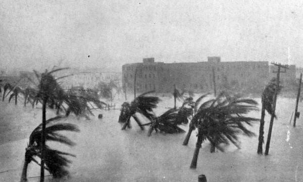
Storm surge is generally a "dome" of water that inundates the entire coastline. Many people picture it more like "tsunami wave" that quickly comes and goes, and hopefully will wash somewhere else.

The picture below is from Miami during the Great Miami Hurricane of 1926. It's one of my favorite storm surge photos because it clearly shows the "dome of water" inundating the landscape and leaving just the tops of palm trees emerging from the water.

The storm tide level in this event reached 15 feet, which is near the upper maximum that the NHC is predicting for SW Florida, including the Naples region. A storm surge of this level will move inland for many miles, inundating everything in its path.


8) How long with the storm surge last?
Storm surge is quite variable in height and timing, depending on the local geography and proximity to the hurricane eye. In general, storm surge will last as long as onshore winds persist. In the Keys and FL west coast, the longest-duration surge events in Irma will occur in the FL Keys- particularly for E or SE facing coastlines.....for SW Florida in locations east of landfall (perhaps Marco Island and Naples).

Along the Atlantic Coast, storm surge levels should be more moderate, but onshore winds will persist throughout the event, keeping a low-moderate surge persisting for more than one day. This may be a problem in places like coastal Georgia, where a 4-6 ft storm surge can be expected, with elevated water levels likely exceeding 36 hours.

This creates a problem with "compound flooding", when prolonged storm surge impedes rainfall drainage. In a compound flood event, an area may flood from 10 inches of rain, when in similar rainfall events the location did not flood. Places like Savannah may observe compound flooding.


9) What about the Florida Panhandle?
The Florida Panhandle should stay to the west of Irma's track, meaning strongest winds should blow offshore and minimize surge levels.


10) How does the storm surge timing relate to the hurricane landfall?
Storm surge timing is location-specific, but we generally need a strong onshore wind to generate storm surge. Peak storm surge levels often accompany the arrival of the eyewall, but if tracking shore-parallel, like in portions of western FL, the peak storm surge will occur after the eye passes and winds shift direction, blowing from the west.


11) I saw pictures of ocean water getting "sucked" out of islands in the Bahamas. Will that happen in Florida?
Water basically obeys the commands of the wind. When wind is blowing strong offshore, water will get pushed out of bays. This will happen in places like Tampa Bay, as Irma approaches from the south. Expect low water levels that expose extensive mud flats. Immediately after the passage of the eye, intense winds from the west, will bring the normal water level back and rapidly generate a storm surge as well. Even if surge levels only reach 3-6 feet near Tampa, expect dramatic swings in water flow direction and water levels.


12) Could Irma just keep drifting west and miss the Keys/ SW Florida? and/or
I've lived in SW Florida for many years and hurricanes usually seem to miss us at the last minute? What is the chance that Irma will miss us too?

A common perception in SW Florida is that hurricanes will turn and miss certain communities. I've heard this sentiment in Siesta Key, near Sarasota, as hurricanes Charley (2004) and Wilma (2005), both made landfall south of this region, leaving them on the "weak side".

I would expect that sentiment to exist around Naples as well. Hurricane Charley made landfall around Punta Gorda, and intense winds impacted areas as far south as Fort Myers, but Charley was a compact storm and Naples emerged with minimal damage from Charley.

Hurricane Charley (2004) made landfall north of Fort Myers as a compact category-4 hurricane. Naples escaped with minimal damage due to Charley's relatively small geographic size.


Wilma made landfall south of Naples, leaving the city on the "weak side"....while generating a storm surge approaching 16 feet near the SW Everglades. People in cities that observe several "near misses"  often begin to assume that something in the local geography protects them from hurricane strikes.

A big difference between Charley/ Wilma and Irma is that Irma is Irma is taking a shore-parallel track, while Charley/ Wilma took more shore perpendicular tracks. Shore-perpendicular hurricanes leave some communities as "winners" when they turn or shift their track, but shore-parallel hurricanes don't "miss" that much, especially if they have extensive wind fields.

Irma is producing hurricane-force winds for 70 miles from the center of circulation and is forecast to track close to the western FL coast. So even if Irma's track shifts 30 miles in either direction, most coastal towns from Naples to Cedar Key, including the Tampa/ St Pete metro area, will likely observe hurricane force winds.


13) Are there any areas where you feel the "official" forecast may be inaccurate?
The official NHC forecast seems to match historical/ empirical context pretty well. One area I have felt the official forecast has been underestimating is the peak surge level in the FL Keys, which I think could reach 10-12 feet.

Storm surge forecasting is tricky, because slight changes in the hurricane track can lead to big differences in storm surge levels. Irma is forecast to track near the west coast of FL as far north as Cedar Key and generally produce a storm surge of 4-6 feet north of Clearwater. If Irma tracks along the western edge of the forecast cone, and stays offshore north of Clearwater, we can expect storm surge levels to reach as high as 6-9 feet in places like Cedar Key.

It's hard to make an exact prediction right now with some uncertainty in the exact track.

Well I successfully finished a blog post with almost all text....which I hate to do.

Under my personal circumstances, it was text or nothing tonight, so please bear with me and hopefully I'll include more visuals soon.

Take care everyone and stay safe! Please email me at hal@marineweatherandclimate.com with any questions or request for media interviews.

Good night!
-Hal


Cat-4 Hurricanes are Catastrophic - A Perspective on Hurricane Irma

Hurricane Irma is barreling towards the Lower Florida Keys and Southwest Florida as a large, powerful hurricane on the threshold of category-4 and -5 intensity. Irma is forecast to remain at least a category-4 hurricane through passage of the Lower/ Middle Florida Keys and southwest Florida coast.


The National Hurricane Center advisory at 5AM this morning forecasts Irma to track through the Lower Florida Keys and SW Florida as a major hurricane. www.nhc.noaa.gov.


Category-4 hurricanes are catastrophic. Here is a description of their wind damage, provided by the National Hurricane Center:

Catastrophic damage will occur: Well-built framed homes can sustain severe damage with loss of most of the roof structure and/or some exterior walls. Most trees will be snapped or uprooted and power poles downed. Fallen trees and power poles will isolate residential areas. Power outages will last weeks to possibly months. Most of the area will be uninhabitable for weeks or months. 
Source: www.nhc.noaa.gov/aboutsshws.php

Irma's hurricane force winds extend outward for 70 miles from the center, meaning communities that do not even take a "direct hit" from Irma will experience destructive winds.


PERSPECTIVE


I am a hurricane/ storm surge researcher and my concern about people staying through a category-4 hurricane comes from personal experience.

I have lived through five "hurricanes", but I have never actually experienced hurricane force winds. The five "hurricanes" I lived through are...
Erin (1995) - Florida;
Gustav (2008) - Louisiana;
Ike (2008) - Texas;
Isaac (2012) - Louisiana;
Harvey (2017) - Texas.

I put hurricanes in quotes because I have never actually experienced hurricane force winds, which are defined as sustained winds of 74 mph or greater.

I have, however, observed tropical storm force winds, sustained around 60-65 mph, as well as the damage caused by hurricane winds soon after landfall.

The worst wind damage I've seen from a hurricane was from Hurricane Gustav. Although Gustav made landfall in South Louisiana as a category-2 hurricane, maximum sustained winds near my home in Baton Rouge were around 60-65 mph with gusts approaching 90 mph.

Those winds were strong enough to make Baton Rouge look like a "war zone" according to many eye witnesses.

Trees crushed houses all over my part of the city. Power was out at my house for 10 days. Damage was extensive. And all this from just "tropical storm force winds", which we might think of as a "category 0 hurricane".

The pics below show Gustav damage in Baton Rouge.


Hurricane Gustav (2008) damage in Baton Rouge, Louisiana


Hurricane Gustav damage in Baton Rouge, Louisiana

Two weeks after Gustav I was doing field work in Texas during Hurricane Ike. The closest I could get to landfall was the city of Orange, Texas.

Although Ike's storm surge was surprisingly high, one of the lasting images I have from that storm is a billboard sheered off and lying in the road. This damage was likely caused by "strong" tropical storm force winds, not exceeding 70 mph.

I cannot imagine living through Irma's passage in places like Naples, Fort Myers, Venice and even Sarasota. It's not imaginable for me because the force of hurricane winds quadruples as wind speeds double. Basic math tells me that the 140 mph sustained winds forecast for SW Florida are five times as destructive as the devastation I experienced from Hurricane Gustav back in 2008.

Irma is will likely weaken slightly as it approaches the Tampa metro area, but may arrive as a category-3 hurricane, which will inflict widespread destruction on the city. Although it is challenging to evacuate large metro areas, people living under trees should be particularly concerned in this region.


TAKE ACTION

It's not too late to evacuate if you live along the SW Florida coast. 

Evacuation is a pain. I personally prefer to shelter-in-place with a stock pile of food and water. Last week when Hurricane Harvey hit Texas I stayed in my home in Galveston, a barrier island southeast of Houston. I am on elevated ground and I felt safe during Harvey because the main hazard in my region was torrential rain, and I live up high.

I would not feel comfortable at all staying in any coastal towns south of Tampa on the Florida Gulf Coast.

Even if I managed to survive the ordeal, my house would likely be unlivable and without utilities for weeks....why stay?

If you are in this area I would urge you to strongly consider evacuating inland to a shelter if you cannot stay with friends or in a hotel.


STORM SURGE

Irma will generate a catastrophic storm surge in Florida Keys with surge levels likely reaching 10-14 feet in Lower and Middle Keys and localized maximum levels of 14-16 feet where the eastern eyewall makes landfall. Of course, all this relies on the hurricane wind and track forecast remaining relatively accurate.

Storm surge in SW Florida could reach these same levels in areas passed by Irma's center to the west, which is most probable from Naples south.

Areas where Irma passes to the east will observe a noticeable "negative" storm surge, where saltwater is pushed out of the bays and estuaries, followed by a sudden rush of a "positive" storm surge immediately after the eye passes.

This is called "wrap around" storm surge (at least I call it that) and surge in those areas should reach around 6-10 feet.

Storm surge near Tampa is highly dependent on the storm track. However, expect a negative surge followed by a positive surge and the possibility of a 4-8 foot storm surge from hurricane force winds blowing in from the southwest after the eye passes.

Keep in mind that storm surge refers to the elevated height of sea level, but does not include the large, destructive waves that may ride on top of a storm surge. So if your first floor elevation is 12 feet and storm surge as high as 10 feet are forecast for your area, imagine a new sea level two feet below your house, with even 3-foot waves washing into your first floor. Scary stuff.

If Irma's track stays just offshore, this will mean higher storm surge for communities along Florida's west coast. It could also lead to a "shelf wave" developing from Clearwater north, as a bulge of water essentially gets trapped between the storm and the coast. This happened in Hurricane Dennis (2005) and it exacerbated storm surge for areas like Cedar Key and St. Marks.

I like to include pics and graphics in my blog posts. However, I'm sending this as mostly text to get this out ASAP.

I'm in the car for most of today, but if you have questions or want to do an interview, please email me at: hal@marineweatherandclimate.com and I will do my best to get back to you.

Thanks and stay safe!
-Hal


Friday, September 8, 2017

Expect Localized Storm Surge Maximum of 14-16 ft in SW FL and FL Keys

Hey everyone- I apologize for the low-tech post here. I had 12 hour field work day and I'm just getting to computer now.

Here are some thoughts on Irma's storm surge potential...

Irma will generate a life-threatening storm surge in the FL Keys and SW Florida.

Irma's forecast track shifted west today, and the storm also appeared to grow in geographic size and re-intensify back to a category 5 hurricane. This is a worst case scenario for Middle and Lower Keys.


FORECAST FOR THE MIDDLE AND LOWER FLORIDA KEYS

I don't understand the official forecast of a 5-10 ft storm surge in the Keys. Observational data of other extreme hurricanes in this area would suggest a widespread 10-14 ft storm surge in the Middle and Lower Keys, with localized maximum in the 14-16 ft range. Storm surge likely 6-10 ft in the Upper Florida Keys (Key Largo).

Examples:
1) The Labor Day Hurricane (1935) was a compact/ small category-5 hurricane that generated an 18-foot storm surge in the Florida Keys. Irma's wind speeds will be lower than the Labor Day Hurricane, but the geographic size is larger. These variables somewhat offset each other, but the Irma's surge will not likely exceed the Labor Day Hurricane's high water mark. 

2) Hurricane Donna (1960) took a similar track as Irma and was a similar geographic size. However, Irma's maximum sustained winds will approach the Florida Keys in the 155-160 mph range, which is around 25 mph greater than Donna. The U-Surge Project has identified five high water marks exceeding 12 ft with a maximum water level of 13.7 ft during Donna. Irma should generate a higher surge than this.


FORECAST FOR SOUTHWEST FLORIDA

A storm surge of 12-16 ft storm surge is possible in SW FL, in places like Naples and Marco Island....but this depends on exact storm track. If storm passes Naples and Marco Island to the east, surge levels would likely reduce to 6-10 ft.

Expect dramatic "negative" surge in places like Tampa Bay, where water will initially be pushed out of the bay, exposing vast mud flats. After Irma makes its closest approach, expect damaging winds in opposite direction to push water back into these bays with shocking speed and intensity. Wall of water will push back into west coast bays after eye passes....likely reaching levels of 3-6 ft above normal.


THOUGHTS FLORIDA ATLANTIC COAST AND GA/ SC

I am feeling more confident that metro Miami and points north, like Palm Beach and Melbourne, escape with less than 5 ft of storm surge. We will have to watch Irma's track closely to see if it approaches NE Florida or the Georgia Coast.

it appears at this time that Irma may track "up" the peninsula or remain closer to the west coast. If this is the case, the Atlantic coast should expect elevated storm surge levels and some flooding, but avoid catastrophic storm surge inundation.

The area of NE FL (north of St. Augustine), entire GA coast and SW South Carolina is quite susceptible to storm surge inundation, and could observe a prolonged storm surge even if Irma's center of circulation is 100 or more miles inland.

CONTACT

I am in the car a lot tomorrow (Saturday). Please email if you have questions or would like to do an interview. I will reply to you as soon as I am able. Thanks!

-HH
Email: hal@marineweatherandclimate.com