Tuesday, March 17, 2015

Did Pam’s Widespread Storm Surge Provide a Glimpse into the Future?


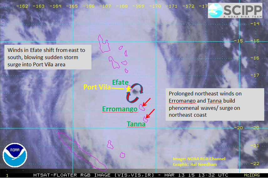
Tropical Cyclone (TC) Pam devastated a large region of the South Pacific last week, as it slammed into Vanuatu, packing winds of 165 mph (265 kph). According to Dr. Jeff Masters’ WunderBlog, TC Pam ranks among the top two most intense cyclones to visit this region; the other was TC Zoe in 2002.

MSNBC quotes Oxfam’s Vanuatu Director, Colin Collet van Rooyen, as stating, “This is likely to be one of the worst disasters ever seen in the Pacific.”

Wind and storm surge inflicted mass destruction across Vanuatu.
Image: Luo Xiangfeng/Xinhua/Associated Press

The world is just beginning to get a better picture of Pam’s destruction in Vanuatu, as aid workers are arriving in rural villages. Beyond the fatalities, injuries and material destruction, food and water shortages are also severe in some locations. ABC NEWS Australia has reported that residents on Vanuatu’s island of Moso were forced to drink salt water to stay alive. Unfortunately, storm surges often destroy the freshwater drinking supplies as they overwash small islands, leaving them without fresh water.

 Although Pam's winds were most severe in Vanuatu, its surge inundated this beach at Tarawa, Kiribati as well.
Image: Plan International Australia

Pam's surge severely damaged the causeway between Betio and Bairiki in Kiribati.
Image: Otobina Karissa Temakei

Although Pam’s fury was greatest in Vanuatu, perhaps the most surprising aspect of this cyclone was its ability to inundate island nations far from its path. Pam’s surge overwashed portions of both Kiribati (pronounced Kiribash) and Tuvalu from great distances. Pam was centered approximately 700 miles (1126 km) southwest of Tuvalu as it inundated this island nation. This remarkable span is equivalent to an Atlantic hurricane striking Georgia while inundating New York City with saltwater, or a non-tropical cyclone centered along Ireland’s southwest coast inundating Portugal.

 Pam's surge severely damaged the Nanumea School House in Tuvalu.
Image: @UNDP_Pacific

The impacts of this widespread surge are tremendous. Solomon Star News reported that the surge has displaced as many as 45% of Tuvalu’s residents, according to Tuvalu’s Prime Minister.

Pam's storm surge inflicted severe impacts on Tuvalu, located at least 700 miles (1126 km) from the storm's path.
Image: @unisdr

As we look to the future, Pam’s surge raises many important research questions. How often have tropical cyclones inundated islands with salt water from 700 miles (1126 km) away? What role does sea level rise play in an event like this? Should we expect more far-reaching surges in the future, as global climate warms and sea levels rise, and, if so, what is the best course of action to minimize losses?

Media Links:


Friday, March 13, 2015

Severe Tropical Cyclone Pam Generates Deadly Waves and Surge in Vanuatu

Severe Tropical Cyclone Pam is generating deadly waves and storm surge in Vanuatu. Pam tracked just east of Efate and Vanuatu's capital city, Port-Vila, as a large category-5 tropical cyclone. Although marine observations throughout Vanuatu are sparse, Pam is certainly generating massive waves and considerable storm surge during this horrific night.

Intense tropical cyclones generate localized storm surge and wave conditions along island chains. This graphic highlights some of the most vulnerable areas to storm surge.


 Severe Tropical Cyclone Pam is generating phenomenal waves and large storm surge. This graphic highlights some of the most vulnerable areas. Image: NOAA RGB Channel, Graphic: Hal Needham


Winds on Efate should have shifted from east to south, blowing sudden storm surge and massive waves onto the southern coastline, including the Port-Vila area. It appears that Pam may have tracked far enough east to keep Port-Vila out of the eyewall, but still expect sudden surge rises on the south coast of Efate.


 Winds on Efate shifted from east to south as Pam tracked close to the island. This wind shift increased surge levels on the southern coast of the Island. Image: www.siliconrepublic.com


Pam will next approach Erromango and Tanna, making landfall or passing just east of these islands. The wind setup on these islands is different, because they have experienced prolonged northeast winds for much of this storm. As Pam approaches these islands, winds from the northeast should increase dramatically, generating massive surges and waves along the northeast coasts. Expect "chaotic" seas on the back sides of these islands, as large waves approach from various directions.

Thursday, March 12, 2015

High Storm Surge Potential as Four Active Tropical Cyclones Spin in the Pacific and Indian Oceans


The tropics continue to threaten high storm surge potential as four active tropical cyclones spin in the Pacific and Indian Oceans.  The cyclones are Severe Tropical Cyclone Pam, which is approaching the Island Nation of Vanuatu, Severe Tropical Cyclone Olwyn, which made landfall in Western Australia and is currently tracking from north to south along the coastline, TC Nathan, which is nearly stationary off the coast of Queensland, and Tropical Storm Bavi, which is in the Northern Hemisphere, and forecast to track on the north side of Micronesia.

http://earth.nullschool.net/
Four active tropical cyclones are visible in this atmospheric circulation map provided by the Earth Wind Map project.
Link: http://earth.nullschool.net/.

Severe Tropical Cyclone Pam threatens to inflict the most severe damage, as this category-5 tropical cyclone bears down on Vanuatu. On Mar 12 at 1800Z, the Joint Typhoon Warning Center (JTWC) estimated Pam’s intensity at 140 kts (259 kph, 161mph), which essentially classifies Pam as a category-5 cyclone in any rating system around the world. Pam is also a large cyclone, which gives greater potential for damaging winds and storm surge generation. Unfortunately, Pam continues to track slightly west of south, and has not yet begun a curve to the south and southeast, which means Pam is tracking perilously close to Vanuatu’s southern islands, and may make a direct landfall.

http://www.ssd.noaa.gov/PS/TROP/floaters/17P/flash-vis-long.html
 NOAA’s visible satellite image shows TC Pam approaching Vanuatu. 
Source: http://www.ssd.noaa.gov/PS/TROP/floaters/17P/flash-vis-long.html

The JTWC estimates Pam’s maximum significant wave height at 13 m (44 ft). Significant wave height is the mean height of the highest one-third of the waves. NOAA’s WAVEWATCH 3 (WW3) ocean modeling predicts similar significant wave heights, with heights building to at least 15 m (50 ft) after Pam passes south of Vanuatu.

http://www.ssd.noaa.gov/PS/TROP/floaters/17P/flash-vis-long.html
 NOAA’s WAVEWATCH3 forecasts significant wave heights, swell heights, wave periods, wind speed and direction.

Storm surge forecasts are not provided for Vanuatu or Fiji, however, Vanuatu Meteorological Services forecasts “phenomenal seas” exceeding 10 m (33 ft) through Sunday. In my previous post, I uploaded photos of storm surge flooding in Tuvalu, approximately 700 miles (1125 km) northeast of Pam. As this storm surge was generated when Pam was less developed, we can only imagine the terrific waves and surge that will pound the coasts of Vanuatu and Fiji during the next 24 hours.

Severe Tropical Cyclone Olwyn made landfall near Exmouth, Western Australia, as a category-3 tropical cyclone, and then took a sight seeing tour as it tracked along the coastline, maintaining category-3 status. As of 11:00AM WST, Olwyn’s maximum sustained winds were 150 kph (93 mph). This intensity would be a strong category-1 hurricane in the Atlantic.

http://www.bom.gov.au/products/IDW60281.shtml
 Severe TC Olywn made landfall in W. Australia near Exmouth, then tracked south along the coast towards Carnarvon.
Source: http://www.bom.gov.au/products/IDW60281.shtml

Tide gauge data from Western Australia's Department of Transport indicated a 1.75-m (5.7 ft) storm surge at Exmouth, and a storm tide level (tide + storm surge) of nearly 3.5 m (11.5). Higher water levels may be observed near Shark Bay, where the bay should trap the surge and enhance water levels.

http://www.bom.gov.au/products/IDW60281.shtml
 Tide gauge data from Exmouth reveals a 1.75-m storm surge (green line) and a storm tide level (storm surge + tide) of nearly 3.5 m (yellow line). Source: http://www.transport.wa.gov.au/imarine/exmouth-storm-surge.asp

As Olwyn tracks south along the coast, it may generate a 0.5- 1.0 m (1.6-3.3 ft) shelf wave along the entire southwest coast, according to Andrew Burton, Regional Forecasting Centre Operations Manager at the Australia Bureau of Meteorology, Western Australia Region. Shelf waves tend to form when cyclones travel parallel to a coastline and trap high water near the coast, such as during Hurricane Dennis when it tracked along Florida's West Coast in 2005. Olwyn's shelf wave may help elevate water levels at many locations above the level of Highest Astronomical Tide (HAT). 

Tropical Cyclone Nathan decided to pay Queensland a visit, but then got a bit indecisive north of Cape Flattery, as it made a sharp turn to the north before reaching the coast. Nathan is a category-2 tropical cyclone, but is forecast to intensify to a category-3 cyclone as it moves back to the east. Australia’s Bureau of Meteorology predicts that abnormally high tides could develop between Coen and Cape Flattery today, possibly leading to minor coastal flooding along the foreshore.

http://www.bom.gov.au/products/IDQ65002.shtml
 Tropical Cyclone Nathan approached the Queensland Coast, north of Cape Flattery, before making an abrupt turn towards the north. Source: http://www.bom.gov.au/products/IDQ65002.shtml. 

I'm sure Tropical Storm Bavi is up to something interesting too, but I'll have to save that for another day. It's not very often that four active tropical cyclones are spinning at the same time! Take care, everyone, and stay safe!

TC Pam Generates Surge Flooding on Tuvalu from ~700 Miles (1125 km) away!

On Thursday, March 12, Severe Tropical Cyclone Pam generated storm surge flooding on Vaitupu Island, Tuvalu, from approximately 700 miles (1125 km) away! This large, powerful tropical cyclone is obviously displacing some serious water, and will likely generate life-threatening storm surges in the island nations of Vanuatu and Fiji.

 Severe Tropical Cyclone Pam generated storm surge and waves that flooded portions of Vaitupu Island, Tavalu, on Thursday, March 12th. At the time of this flooding, Pam was centered approximately 700 miles (1125 km) to the southwest. Image: @Niuslady


 Severe Tropical Cyclone Pam generated storm surge and waves that flooded portions of Vaitupu Island, Tavalu, on Thursday, March 12th. At the time of this flooding, Pam was centered approximately 700 miles (1125 km) to the southwest. Image: @Niuslady

Storm surge will be highest where the most intense winds blow onshore. Surges along island chains are often quite localized, as one location experiences a strong onshore wind and high surge, while locations nearby may experience strong offshore winds and low/modest surges. A lot depends on the direction the coastline faces, as well as the presence of bays and inlets, which tend to enhance surge during onshore winds.

This map provides georeferenced storm surge photos and videos, as well as Pam's storm track. It will be updated regularly though this storm. Stay safe, everybody!

https://www.google.com/maps/d/viewer?mid=zxEnE9QAEd8k.kvhypk7i5qMA
This map provides georeferenced storm surge photos and videos, as well as Pam's storm track