
Tropical Cyclone Chapala produced maximum sustained winds reaching 155 mph, while traversing the Arabian Sea, according to Weather Underground.
Image: http://blogs.channel4.com/liam-dutton-on-weather/wp-content/uploads/sites/27/2015/10/chapala_sat_CIMSS_wp.jpg
Chapala's greatest impact was flash flooding form torrential rains, which could reach 3-4 times the average annual rainfall, according to an article posted by The Weather Channel yesterday.
People in lush landscapes sometimes are surprised to hear about the impact of heavy rains in arid regions. In subtropical climates with plentiful rainfall, dense foliage and deep organic matter on the ground serve to break the fall of rain and soak up much water. In arid climates, however, vegetation in sparse and soil is thin, so much of the rainfall lands on rock and immediately runs off.

Steep mountains with limited vegetation will enhance heavy rainfall runoff near the city of Mukalla, Yemen.
Image: www.arastiralim.net
Such is the case in Yemen, where photos and videos of flash flooding are depicting catastrophic impacts, particularly near the city of Mukalla.

Runoff from heavy rains engulfed the city of Mukalla, Yemen, on Tuesday.
Image: @saeedalBatati

Video from Mukalla shows catastrophic flash flooding underway, as people try to rescue neighbors from a raging torrent.
Historically, heavy rainfall has produced the most severe tropical cyclone impacts in this region. Heavy rainfall from a storm in 1890 produced the most recorded tropical cyclone deaths in the Arabian Peninsula, as the storm killed 727 people and destroyed approximately 100,000 date trees in Oman, which was a massive agricultural loss (Bailey, 2008; Blount et al., 2010).
In regards to coastal flooding, the Yemeni coast fortunately has deep bathymetry, or water depth. Deeper bathymetry minimizes storm surge levels, while elevating the level of waves. This explains why coastal flooding videos coming out of Yemen today depict large waves striking the coast, but we have seen little in the way of serious coastal flood impacts.
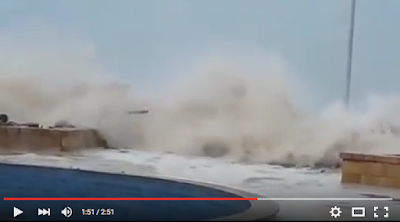
Chapala generated large waves that pounded the Yemeni coastline near Mukalla on Monday afternoon. This video depicts water inundating the coastline after the waves crash into rocks and seawalls. Coastal inundation likely became more severe Monday night and Tuesday as Chapala approached the coastline.
The coastal profile of Yemen can be contrasted with flatter locations in the Northern Indian Ocean region, like Bangladesh, which contains flat topography both onshore and offshore. Storm surges in Bangladesh have reached the highest level in recorded history anywhere on Earth.
In the Arabian Peninsula, topography and bathymetry are flatter in Oman than Yemen, enabling surges in Oman to reach higher levels. Tropical Cyclone Gonu generated maximum water levels (storm tide + wave runup) of approximately 16.5 ft (5 m) in Oman in the year 2007 (Fritz et al. 2010), which is the highest coastal inundation level on record for the Arabian Peninsula (Needham et al. 2015).

Deep topography along the Yemeni coast minimized storm surge levels from TC Chapala. This can be contrasted with Bangladesh, which has a flat coastal profile and shallow bathymetry.
Map edits: Hal Needham
A good rule of thumb, which is generally true, is that topography onshore tends to mirror topography offshore (bathymetry). This is not true in all cases, but in general, "flat" coastal regions, like Bangladesh, and Louisiana in the United States, tend to observe shallow bathymetry offshore and experience high surges. However, mountainous areas like Hawaii or Taiwan contain deeper bathymetry and observe lower storm surges (but higher waves).
Such generalizations can be helpful, but can also lead us to underestimate storm surge potential. The Philippines stands out as a mountainous region that has observed catastrophic storm surges, mostly because extremely intense tropical cyclones tend to push water rapidly into the numerous bays and coastal inlets.
Unlinked References
Bailey, R. W. (Ed.) (2008), Records of Oman: 1867–1947, 8 vols., Archive Editions, Buckinghamshire, U. K.
Blount, C. D., H. M. Fritz, and A. H. M. Al-Harth (2010), Coastal vulnerability assessment based on historic tropical cyclones in the Arabian Sea, in Indian Ocean Tropical Cyclones and Climatic Change, edited by Y. Charabi, pp. 207–214, Springer, New York,doi:10.1007/978-90-481-3109-9_25.
Fritz, H. M., C. D. Blount, S. Thwin, M. K. Thu, and N. Chan (2010a), Cyclone Nargis storm surge flooding in Myanmar’s Ayeyarwady River delta, in Indian Ocean Tropical Cyclones and Climatic Change, edited by Y. Charabi, pp. 295–303, Springer, New York, doi:10.1007/978-90-481-3109-9_34.
Needham, H.F., B.D. Keim, and D. Sathiaraj, 2015: A review of tropical cyclone-generated storm surges: Global data sources, observations and impacts. Reviews of Geophysics, doi: 10.1002/2014RG000477.