Severe Tropical Cyclone Winston struck Fiji over the weekend as a
monster cyclone with maximum sustained winds of 185 mph at landfall. This makes
Winston the strongest recorded cyclone in the Southern Hemisphere, and tied for
the third highest wind speed at landfall, according to Jeff Masters’ Wunderblogpost from Saturday.
According to ABC News in Australia, the cyclone has now killed at least 21 people.

According to ABC News in Australia, the cyclone has now killed at least 21 people.
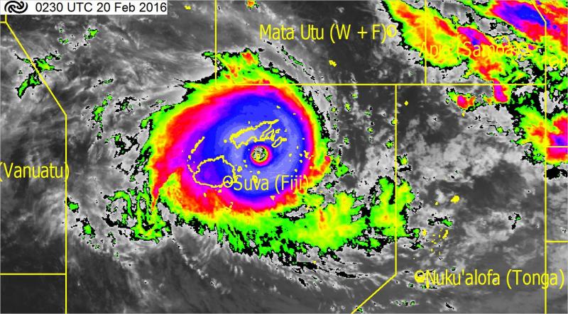
Severe Tropical Cyclone Winston as it approached landfall on Viti Levu on Sat Feb 20, 2016.
Image courtesy MetService New Zealand.
Air photos provide initial evidence of a storm surge of approximately 10 ft (3 m) in some coastal areas. More specifically, these high water marks are actually a
combination of storm tide and waves, as tree bark removal is the primary means
for such observations in the first days following a severe cyclone.
Post-storm photographs often show a sharp color distinction on many trees at around the same level. The power of water rapidly racing past the tree will rub off tree bark, and leave behind evidence of maximum water levels. In the photographs below, I've drawn arrows pointing at these lines. The color on these trees is grey below the line and brown above it. I think the arrow farthest on the right in the first photograph most clearly demonstrates this contrast.
We can use other trees and the features on the buildings, like doors and windows, to get a rough idea of the scale. It appears that the height of tree bark removal is around 10 ft (3 m) in these photos, although future field work could more accurately make these measurements.

Sharp contrasts in tree trunk color indicates the height of extreme water levels at this location in coastal Fiji.
Original Source: NZ Defence Force; Edits from Dr. Hal Needham

Sharp contrasts in tree trunk color indicates the height of extreme water levels at this location in coastal Fiji.
Original Source: NZ Defence Force; Edits from Dr. Hal Needham
The use of tree bark removal as a proxy for extreme water levels has been established as a credible field work technique, and has emerged as a useful practice in areas without operational tide gauges.
Dr. Hermann Fritz, Associate Professor of Engineering at Georgia Tech University, led a reconnaissance effort to measure extreme water levels in three states following Hurricane Katrina in 2005 (Fritz et al. 2008). Measuring the height of tree bark removal was one field method that was most useful in many cases, enabling them to measure extreme water levels that exceeded 26 ft (7.92 m) in some cases. See my previous post about this and other field methods.
 A 25.1-ft (7.65-m) rod does not quite reach the height of tree bark removal on East Ship Island, Mississippi, following Hurricane Katrina. The tree bark removal at this site extended to 8.2 m (26.9 ft), indicating an extraordinarily high storm surge at this location. Photo provided by Dr. Hermann Fritz.
Dr. Hermann Fritz, Associate Professor of Engineering at Georgia Tech University, led a reconnaissance effort to measure extreme water levels in three states following Hurricane Katrina in 2005 (Fritz et al. 2008). Measuring the height of tree bark removal was one field method that was most useful in many cases, enabling them to measure extreme water levels that exceeded 26 ft (7.92 m) in some cases. See my previous post about this and other field methods.
Aslak Grinsted, an assistant professor at the Niels Bohr Institute, utilized tree photos to quite accurately estimate maximum water levels from Super Typhoon Haiyan in the Philippines in 2013. This blog post provides the story of how this researcher in Denmark used modern technology to estimate water levels in the Philippines.
As Winston approached Fiji, waves offshore were reported as high as 39 ft (12 m), according to the New Zealand Herald and BBC News. Many places in Oceania commonly observe extraordinarily high waves, but modest storm surge heights, because the bathymetry, or offshore water depth, is relatively deep in this region of the world.

Waves smash over a seawall at Uprising Beach Resort, west of Suva, Fiji, on Sat Feb 20. Offshore waves reached as high as 39 ft (12 m). Photo Courtesy ABC News Australia.
It is likely that higher water marks will be observed, as Fiji is an archipelago with more than 300 islands, and today's blog post just examines two photos. If that maximum surge holds at around 10 ft (3 m), that would make this surge event comparable, or slightly lower, than the surge produced by Tropical Cyclone Oscar in 1983, on Beqa Island, Fiji (Terry 2007). Oscar produced a storm surge as high as 9.8 - 13.1 ft (3-4 m)
Browne and Krishna, staff at the Fiji Meteorological Service, wrote about Oscar's storm surge in a 1983 report published in Weather and Climate. Below is an image of their text about the storm surge and a map of Oscar's track relative to Fiji, which also comes from the report.


Oscar's storm surge is the highest credible storm surge level recorded in Fiji, according to the SURGEDAT global storm surge database (Needham et al. 2015). The New Zealand Herald reported a storm surge of 23 ft (7 m) from Tropical Cyclone Tomas, which struck Fiji in 2010, however, this report was not scientifically verified.
As we try to better assess the damage in Fiji, determining maximum water levels is important, because in many island regions of Oceania, saltwater overflowing islands can contaminate limited drinking water supplies and agricultural products. This is most pronounced on small, low-lying islands. Even relatively small storm surges can inflict long-term impacts if they contaminate food and water.
Here are some ways you can help with this assessment:
Browne and Krishna, staff at the Fiji Meteorological Service, wrote about Oscar's storm surge in a 1983 report published in Weather and Climate. Below is an image of their text about the storm surge and a map of Oscar's track relative to Fiji, which also comes from the report.
Oscar's storm surge is the highest credible storm surge level recorded in Fiji, according to the SURGEDAT global storm surge database (Needham et al. 2015). The New Zealand Herald reported a storm surge of 23 ft (7 m) from Tropical Cyclone Tomas, which struck Fiji in 2010, however, this report was not scientifically verified.
As we try to better assess the damage in Fiji, determining maximum water levels is important, because in many island regions of Oceania, saltwater overflowing islands can contaminate limited drinking water supplies and agricultural products. This is most pronounced on small, low-lying islands. Even relatively small storm surges can inflict long-term impacts if they contaminate food and water.
Here are some ways you can help with this assessment:
ACTION ITEMS:
1)
Do you know the location of either of the air photos shown in this blog? If
so, please reply to this post or contact me at hal@marineweatherandclimate.com
or hal.needham@galvestonhistory.org.
We will have much better estimates of maximum water levels once we understand
where this location was relative to the storm center.
2)
Do you have photos that show tree bark removal,
or other evidence of high water marks, such as structures that have been washed away? If so, send to email above or
post on Twitter with hashtag #Winstonhighwater.
Thanks, everyone. Obviously, our thoughts and prayers are
with our friends in Fiji who are suffering through the aftermath of this
powerful storm. Let's hope for a quick recovery.
-Hurricane Hal
-Hurricane Hal
REFERENCES:
Fritz, H.M., C. Blount, R. Sokoloski, J. Singleton, A. Fuggle, B.G. McAdoo, A. Moore, C. Grass, and B. Tate, 2008 : Hurricane Katrina Storm Surge Reconaissance. Journal of Geotechnical and Geoenvironmental Engineering, 134, 5, 644-656.
Needham, H.F., B.D. Keim, and D. Sathiaraj, 2015: A Review of Tropical Cyclone-Generated Storm Surges: Global Data Sources, Observations and Impacts. Reviews of Geophysics, 53 (2).
Terry, J.P., 2007: Tropical Cyclones: Climatology and Impacts in the South Pacific. Published by Springer. 212 pp.


