Alex’s peak surge estimate based on historical surge data #4
June 29, 2010
0800 CDT
Alex’s peak storm surge estimate based on historical surge data and the NHC forecast track and intensity:
Peak surge height estimate: 4-6 feet
Peak surge location estimate: South Padre Island, TX
Update: The NHC track forecast has shifted slightly north since yesterday evening. According to the present track, Alex should make landfall perhaps 30-50 nautical miles S of Brownsville, TX. However, Alex is still somewhat disorganized and still not a hurricane. It seems most likely that it would make landfall as a CAT 1 hurricane south of the TX border. I've not changed the surge estimate, as the storm should track slightly closer to the coast than previously predicted, but it will likely be a bit weaker than previously predicted.
Research through the SCIPP program identified three historical hurricanes that came off the Yucatan Peninsula, made landfall in northeast Mexico, and produced surges greater than or equal to 4-feet along the S TX coast. These events are:
Hurricane Emily
2005
Max surge: 5 feet at South Padre Island, TX
Cat 3 at landfall
Landfall wind speed 110 kts
Landfall position 75 nautical miles S of Brownsville, TX
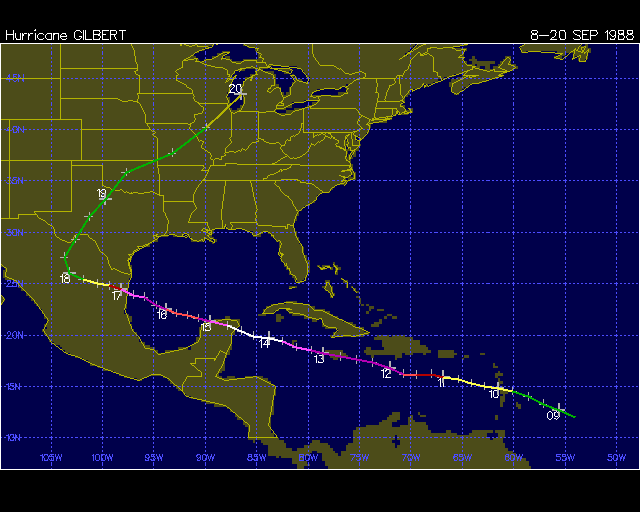
Hurricane Gilbert
1988
Max surge: 6 feet at South Padre Island, TX
Cat 4 at landfall
Landfall wind speed 115 kts
Landfall position about 130 nautical miles S of Brownsville, TX
Unnamed Storm
1909
Max surge: 6 feet at South Padre Island, TX
Cat 3 at landfall
Landfall wind speed: 105 kts
Landfall position about 120 nautical miles S of Brownsville, TX
All three of these hurricanes produced surges between 5-6 feet at S Padre Island. Images of all three tracks are included in this blog.
The NHC track places Alex’s landfall closer to the TX border than any of these events. Alex is forecast to be weaker than these previous events, however, because Alex’s circulation is so large, the surge may be comparable to the other three events.
The NHC has forecast a 3-5 foot surge near and to the north of the point of landfall. However, this forecast may be a bit low, as typical category-1 hurricanes generate 4-6 foot surges, and Alex has a large area of circulation, which should produce an even larger surge. Based on historical comparisons, it would seem reasonable that the peak surges on the Mexican coast are 5-7 feet, and peak surges near South Padre Island are 4-6 feet.
Also, Alex has a broad circulation area, which means the surge values decrease more slowly than normal from where the eyewall makes landfall. Because the coast of extreme S TX faces east-northeast, onshore winds may be observed near S Padre Island for more than 18 hours, given the current NHC forecast track. It would make sense that this should enable at least 4 feet of surge to pile up, but, again, this is just an estimate based on historical comparisons.
Thanks!
Hurricane Hal
Disclaimer: This product is not a forecast. It is a surge estimate based on comparisons to historical storm surge events. This product is experimental and should not be used for decisions included, but not limited to, evacuations, storm preparations, insurance claims, or any decisions that may result in loss of life, injury, or personal, corporate or public economic losses. Louisiana State University, the University of Oklahoma, the SCIPP program, as well as Hal Needham and associated faculty, staff and students involved in developing this product, are not liable for any decisions that lead to injury, death, or any personal, corporate or public losses, including economic losses associated with this storm surge event.