Wednesday, September 29, 2010

Choppy water at Islamorada


Webcams throughout the Middle and Upper Florida Keys depict choppy water, but little storm surge this afternoon. This cam from Islamorada, on Upper Matecumbe Key, shows some choppy water with whitecaps. Expect conditions to remain unsettled this afternoon and tonight as Nicole passes east of the area. Storm surge should remain low, less than 2 feet.

Webcam address: http://www.fla-keys.com/webcams/islamorada_cam.htm

Tropical Storm Nicole


Tropical Storm Nicole formed this morning, and is moving quickly to the NNE. The system already crossed Cuba and is forecast to continue tracking NE, between Florida and the Bahamas. This weak tropical system should pass east of the Florida Keys.

The Southern Climate Impacts Planning Program (SCIPP) identified 17 storm surges that produced peak surge levels in the Florida Keys between 1880 and 2009. Fortunately, Nicole resembles none of these past events. This is likely because Nicole's track and intensity will make it very difficult for the system to generate a 4-foot or greater surge in the Florida Keys. The surge events that SCIPP identified all were at least 4-feet high.

Look for breezy conditions with occasional squalls in the Florida Keys throughout the day. Winds may increase suddenly in squalls, accompanied by heavy rain. Surge levels should remain small, less than 2 feet, however, waters may be choppy.

Wednesday, September 15, 2010

Looking back at Tropical Storm Hermine


Tropical Storm Hermine made landfall in extreme Northeast Mexico at approximately 8PM (local time), September 6, 2010. The storm quickly tracked into South Texas, producing torrential rains, wind damage, and some minor coastal flooding from the onshore flow. Here's an interesting surge-related article posted on the National Weather Service Brownsville, TX Webpage.

Link:http://www.srh.noaa.gov/bro/?n=2010event_herminesurge

[start of quote]
Tropical Storm Hermine
Storm Surge Summary
Peak Water Rises Occur at Low Tide, but Impacts Felt in Channels
Rapidly increasing winds turning from east to south as the center of Tropical Storm Hermine scooted across Cameron, Willacy, and into western Kenedy County overnight on September 6th and 7th brought a push of water onto the beaches and into the Brownsville Ship Channel. For primary residential and beach areas, the push occurred near low tide (first two graphs below), which produced no inundation issues, but water was able to reach the dune line and shut down vehicle traffic at public beach access points beginning during the afternoon of the 6th and continuing overnight.

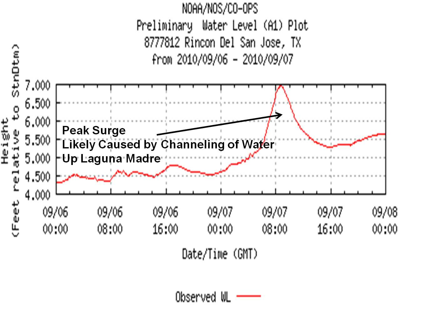
More interesting is what occurred when the water was forced through the thinning Laguna Madre and the Brownsville ship channel. The third graph below shows a much larger spike in water levels at Rincon del San Jose (Kenedy County) where the Laguna Madre runs through sand, salt, and mud flats on its way to Baffin Bay. Data suggest that a surge perhaps as high as 4 feet occurred during the pre dawn hours of September 7th, near the time of high tide. Reports from the Port of Brownsville indicated heavy wave action within the channel, with waves breaking over channel barriers around the time of Hermine’s passage to the west. [end of quote]

Although the preceding account mentions the possibility of a 4-foot surge at Rincon del San Jose, TX, the graph appears to show less than 3 feet of water rise. A second graph, obtained from NOAA Tides and Currents, indicates water levels at the same location between Sept 4 and Sept 9, indicates that maximum water levels peaked less than 3 feet above normal conditions during Hermine. Sometimes water gauge data is adjusted and "cleaned up" in the quality control process, to remove potential errors, which may explain the difference in units between these two graphs.

Nonetheless, the NWS office at Brownsville posted a nice storm archive on their Website, which contains a storm overview, radar loops, wind and rain tables, as well as information on the storm surge. This type of information is valuable after a storm passes.

Tropical Storm Karl


Tropical Storm Karl weakened over the Yucatan Peninsula today, but will strengthen over the open waters of the Bay of Campeche and Gulf of Mexico on Thursday and Friday. The National Hurricane Center forecasts that Karl may regain hurricane strength before making landfall in Mexico.

Karl should stay well south of the Texas Coast, reducing any surge-related impacts in the U.S. The current NHC forecast keeps Karl more than 250 miles south of South Padre Island, TX. This means that although some waves and rip currents could impact South Texas, storm surge should be minimal- likely less than 2 feet.

Stay tuned to 2010 Storm Surge Blog if changes in Karl's track bring the system closer to Texas.

Thursday, September 9, 2010

Trouble in the Gulf next week?


It's not Tropical Storm Igor. It's not even the remnants of Tropical Storm Gaston. The tropical wave that could spell real trouble for the Gulf of Mexico next week is just called "Invest 92" (Investigative Area 92), but this wave could soon form into Tropical Storm Julia and cause trouble for the U.S. Gulf Coast.

The tracking models available on www.wunderground.com show this wave likely moving west-northwest, traversing the Caribbean later this week, and heading on a course that could put it in the Gulf of Mexico next week. The intensity models demand attention as well. The SHIPS model estimates maximum sustained winds of 116 MPH 120 hours from now, and graphs of both the SHIPS and IVCN model show this system blowing up over the next 3-5 days.

Stay tuned to 2010 Storm Surge Blog for storm surge updates as this system develops.

Tuesday, September 7, 2010

Hermine's peak U.S. storm surge likely between 2 and 4 feet


Tropical Storm Hermine made landfall in extreme Northeastern Mexico yesterday evening, generating maximum sustained winds of near 65 MPH. Much of the Texas Coast experienced a strong onshore flow, with strong winds and heavy rains.

Hermine most likely produced a storm surge between 2 and 4 feet. The Corpus Christi Caller reported water levels reaching the dunes on Padre and Mustang Islands.

Link: http://www.caller.com/news/2010/sep/06/little-effect-expected-locally-from-hermine/?partner=popular
Quote: "Storm surges are expected to raise water levels 2 feet to 4 feet above sea level. High tides Monday were reported by the National Weather Service to have reached up to dune areas in northern parts of Padre Island and Mustang Island."

Tide gauges at South Padre Island Coast Guard Station and Port Isabel, TX, reported peak water levels approximately 1.5 feet above normal. However, given the localized nature of storm surge, it is common for the peak storm surge to occur where tide gauges are absent.

The Brownsville Herald and South Padre Island Breeze newspapers did not report any storm surge levels or surge-related damage this morning. CNN provided the picture on this blog post.

Expect surge levels and wave action to diminish throughout the day today.

Monday, September 6, 2010

Hermine nears Northern Mexico Coast, expect small surge in South Texas


Tropical Storm Hermine is approaching the coast of Northern Mexico this evening. Maximum sustained winds have increased to 60 MPH, with some slight intensification still possible.

As Hermine is forecast to produce tropical storm force winds along the extreme South Texas Coast (see latest National Weather Service forecast for South Padre Island, Texas), this system will likely produce a small U.S. storm surge. As mentioned earlier this season, tropical systems that make landfall in Northern Mexico generally produce peak U.S. storm surges near South Padre Island, Texas. The peak U.S. surge in this case will likely be small, probably between 2 and 4 feet, as discussed in this morning's post that compared Tropical Storm Hermine to Tropical Storm Arlene (1993).

The satellite image included in this blog post shows that most of Hermine's activity is still over the open water of the Gulf of Mexico. The wind speed at Brownsville/ South Padre Island Airport as of 6PM CDT was only 10 MPH from the NE, which explains why surge levels are still relatively low. As of 6:30PM CDT the surge levels at both the South Padre Island Coast Guard Station and Port Isabel, Texas, were between 1 and 1.5 feet. Expect wind speeds, rain and surge heights to increase as squalls move onshore later this evening.

Looking back at Tropical Storm Arlene


In June 1993, a tropical depression formed in the Bay of Campeche. This depression tracked northwest, then developed into Tropical Storm Arlene off the South Texas Coast, before making landfall in South Texas, between South Padre Island and Corpus Christi. This image, provided by Unisys Corporation, shows the track of this system as a depression (green) and as a tropical storm (yellow).

Arlene was a minimal tropical storm, generating maximum winds of 40 MPH. However, because this system moved very slowly in the 18 hours before landfall, it was still able to generate some noticeable storm surge. The SCIPP program identified a maximum storm surge of 4 feet in South/ Central Texas in association with Arlene.

Tropical storms Hermine and Arlene have several similarities and differences in relation to storm surge potential. Hermine developed into a tropical storm farther off the coast, likely enabling it to push more water than Arlene. Hermine's winds should also be stronger; the National Hurricane Center forecasts a most likely intensity of 58 MPH before landfall, whereas Arelene's winds never topped 40 MPH. These factors would lead one to expect a higher surge from Hermine.

However, Hermine is moving faster than Arlene, as the current forward speed is 10 MPH and the National Hurricane Center forecasts that Hermine should pick up forward speed today. Generally, faster moving tropical cyclones generate lower surges, so in this regard, Tropical Storm Arlene had a more favorable storm surge setup. Also, it is most likely that Hermine will make landfall in Northern Mexico, which would likely reduce the U.S. surge levels.

As all of these factors are taken into consideration, we might expect Hermine to produce a similar peak U.S. storm surge as Arlene- around 4 feet, if Hermine makes landfall in Texas. If Hermine makes landfall in Mexico, peak U.S. surges should be lower, perhaps between 2-4 feet.

Stay tuned to the 2010 Storm Surge Blog for updates twice daily until landfall. After landfall look for possible observation updates, which may include tide gage graphs and photos.

Tropical Storm Hermine


Tropical Storm Hermine has developed in the Southwestern Gulf of Mexico. Hermine is forecast to track northwest, making landfall in Northeastern Mexico or South Texas on Tuesday morning. Stay tuned to 2010 Storm Surge Blog for the latest storm surge information.