An extraordinary onshore wind and surge event will develop
along the Eastern Seaboard over the next several days. Although Hurricane
Joaquin is grabbing the headlines, and may directly produce the greatest
wind, rain and surge impacts, Joaquin is just one of three players taking part in a complex drama that will unfold over the next several days.
The first player is a cold front and associated
low-pressure system that dumped 2-4 inches of rain across a wide area from Virginia through Maine from Tuesday through Wednesday. This heavy rainfall saturated soils and elevated rivers, which will compound impacts from approaching Joaquin. Saturated soils will cause more of Joaquin's rainfall to runoff and cause flooding, while increasing the risk of downed trees, as wet soil provides less support than dry soil.

During the 24 hours preceding 1200GMT (8:00AM EDT) on Wed Sep 30, between 2 and 4 inches of rain fell across a widespread area from Virginia through Maine. Image: http://water.weather.gov/precip/.
Player #2 is a large area of high pressure building over eastern Canada behind this cold front. The strong pressure gradient between this massive area of high pressure and Hurricane Joaquin, Player #3, will generate prolonged onshore winds from North Carolina through New York. These winds will begin to blow hard long before Joaquin's arrival.

GOES Floater RBTOP-IR Satellite Image of Hurricane Joaquin accessed 4:46AM EDT on Thu Oct 1. The pressure gradient between Joaquin and strong high pressure over Canada will enhance wind and surge impacts. Image: www.ssd.noaa.gov.
The duration of this wind event is absolutely mind-boggling. Data from the National Weather Service point forecast for Atlantic City International Airport (ACY), New Jersey,
suggest a strong onshore wind event will occur over coastal New Jersey for more than 100 consecutive hours (Yes, four days and then some)! Let me explain in more detail.
-->
I've
defined a "prolonged onshore coastal wind event" as a scenario in which winds
along the Mid-Atlantic (New Jersey in this case) coast blow from between the N and E (compass bearings 0 to 90 degrees), with maximum sustained
winds ≥ 20 mph for at least 75% of the observed hours. I chose these compass directions because Ekman Transport tends to deflect water to the right of the wind direction in the northern hemisphere, making a NE wind very efficient at piling up water along the East Coast.

A strong onshore wind event is forecast to impact the Mid-Atlantic Coast along the Jersey Shore for more than four consecutive days (112 hours), generating a prolonged storm surge. Image of Atlantic City: taketours.com
Using this metric, coastal New Jersey will observe a strong onshore wind event lasting 112 hours, based on point forecast data for ACY. This forecast predicts that winds will exceed 20 mph by 12PM EDT on Thu Oct 1 and remain above this threshold for 88 out of 90 hours, until 5AM EDT on Mon Oct 5. Mind you that this extraordinary wind event occurs before Joaquin even makes its closest approach!

The National Weather Service Point Forecast for Atlantic City International Airport, New Jersey, predicts northeast winds will reach 25 mph, with gusts to 40 mph during the day on Friday. An extended view of this graph reveals a strong onshore wind event will last ~ 90 hours before Joaquin even arrives. Image: forecast.weather.gov; edited by Hal Needham.
Winds are then forecast to drop slightly below the 20 mph threshold, before quickly increasing with the closest approach of Joaquin. Adding the winds from Joaquin's closest approach increases our coastal wind event to 112 hours, with onshore winds ≥ 20 mph forecast at 102 of those 112 hours (91.1% of observations).
Of
course, much uncertainty remains regarding Joaquin's track, timing and
intensity. But the big picture here is that a prolonged coastal wind
event will occur even before Joaquin arrives, making coastal flooding and erosion impacts more likely.

The strongest winds along the Mid-Atlantic coast should arrive late Mon into early Tue, according to this National Weather Service point wind forecast for Atlantic City. Note that Joaquin is forecast to impact this area AFTER a 90-hour strong onshore wind event. Image:
forecast.weather.gov; edited by Hal Needham.
This developing situation is truly historic and has not been observed in the modern history of the Mid-Atlantic Coast. I worked with Josh Gilliland, a PHD student at Louisiana State University, and the only Cleveland Brown's fan I know, to analyze the wind history for ACY. We were interested to find previous events that may have resembled the current forecast. Hourly wind data were from 1950-2015 were provided by the National Climate Data Center's Integrated Surface Database (NCDC-ISD), available at http://www.ncdc.noaa.gov/oa/climate/isd/. Gilliland adjusted these obs to 10 m height, in accordance with wind data standards.
We found only six previous "prolonged wind events" that lasted ≥ 48 hours at ACY. None of these events were produced from onshore wind events, as they all were related to frontal passages, with strong winds blowing from the NW. All of these events occurred during winter or spring. I have listed the six events below:
Rank
|
Year
|
Month
|
Date(s)
|
Duration
(hours)
|
Obs
≥ 20 mph
|
% Obs ≥ 20 mph
|
Wind Direction
|
1
|
1975
|
Apr
|
4-7
|
94
|
76
|
80.9
|
Offshore
(NW)
|
2
|
1962-1963
|
Dec-Jan
|
30-2
|
72
|
62
|
86.1
|
Offshore
(NW)
|
3
|
1959
|
Jan
|
4-7
|
72
|
54
|
75
|
Offshore
(NW)
|
4
|
1960
|
Feb
|
18-21
|
69
|
53
|
76.8
|
Offshore
(NW)
|
5
|
1973
|
Mar
|
17-20
|
63
|
61
|
96.8
|
Offshore
(NW)
|
6
|
1985
|
Feb
|
7-9
|
53
|
48
|
90.6
|
Offshore
(NW)
|

Duration of prolonged wind events at Atlantic City, NJ, from 1950-2015. Data provided by National Climate Data Center's Integrated Surface Database (NCDC-ISD).


A
storm surge of approximately 2.5 ft and a storm tide of 7.09 ft above
MLLW were recorded at Sandy Hook, NJ, during a prolonged onshore wind
event in January, 1956. The event this week should last considerably
longer
with local onshore winds likely blowing harder than in 1956. Data and graph: NOAA Tides and Currents.
So what does all this mean?
First of all, we are moving into new territory.
For now, one of the take home points is that this widespread wind event will create a long-duration storm surge even if Hurricane Joaquin does not make a direct landfall on the U.S. Atlantic Coast.
Also, even if Jaoquin's storm surge levels do not come close to those produced by Hurricane Sandy (2012) along the Mid-Atlantic Coast, or Isabel (2003) along the NC/ VA coast and Chesapeake Bay, the combination of long-duration surge and heavy rainfall on previously saturated soils, may flood some areas that were not inundated from Isabel or Sandy.
We should also consider these factors:
1. This surge event will last for many high tide cycles. The impacted region observes two high tides per day, so a 5-day surge event may stick around for 10 high tides. This will increase the risk of flooding in many locations.

2. Joaquin may flood areas not flooded by Sandy or Isabel, even if those storms produced higher surges at the coast. I am particularly concerned about areas "slightly" inland, such as 5-15 miles from the coast. How can rainfall drain into bays and rivers when they are elevated for multiple days from storm surge?
3. Even though our analysis focused on coastal New Jersey, wind, rainfall and surge impacts will likely extend from the Carolinas to New England.
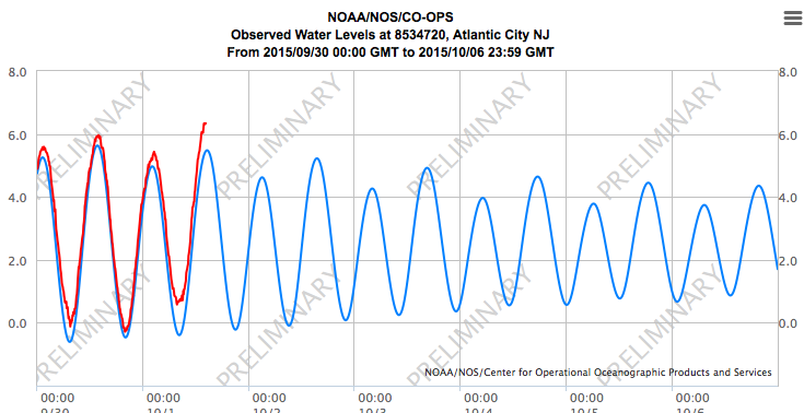
Tide predictions (blue) and observed water levels (red) at Atlantic City, NJ. The long-duration onshore wind event produce high water through two high tide cycles per day. The National Weather Service predicts water levels could reach 7.5 ft above MLLW at this location by 6AM EDT on Fri Oct 2. Many more days of strong onshore winds will follow.
Image: NOAA Tides and Currents.
We're facing multiple-hazards here and the interactions between rain and surge are complex to say the least.
If you've made it this far I would like to extend a hearty congratulations for making it through one of my longest blog posts ever! Well done, my friend!
Stay tuned to the National Hurricane Center, your local National Weather Service Weather Forecast Office, and your local media for future developments related to this complex forecast. I will continue to update this blog daily through the passage of Hurricane Joaquin.
-->
This is really a nice post. Whether the water damage comes from plumbing leaks, storm damage & frozen pipes, you can contact Regional Property Group for the good service of Storm Damage Calvert County.
ReplyDeletePBC88 is Bangladesh's most fulfilling cricket betting web page, offering comprehensive insurance of local and international matches. With consumer-friendly interfaces and stable transactions.
ReplyDelete