Tropical Storm Cindy has developed in the central Gulf of Mexico. Torrential rains from Louisiana through the Florida Panhandle will grab the spotlight, as destructive winds should not develop and coastal flooding remains minor.

The 7:00AM National Hurricane Center (NHC) advisory places the center of circulation for Potential Tropical Cyclone 3 approximately 300 miles south of Morgan City, Louisiana. The NHC forecasts this system to become better organized into a tropical storm and track towards the northwest.
Note the area of tropical storm force winds depicted on the map above. These winds are offset from the center due to southwesterly wind shear. Typically when winds are offset from the center like this, they do not provide consistent coverage over the entire area, but are more found in the heavier squalls. This means that the system is not producing a wide enough coverage of strong winds to generate substantial coastal flooding.

The greatest coastal flood potential exists along the Mississippi Coast and in southeast Louisiana, east of the Mississippi River. Coastal flood levels near the center of circulation, in south central and southwest Louisiana, should be noticeably lower than locations 100+ miles to the east (east of Mississippi River).
This offset should occur for two reasons: 1) Most of the convection is offset to the north and east; 2) Coastal Mississippi and the area of Louisiana east of the Mississippi River is more efficient at piling up storm surges than areas to the west, near Morgan City or Cameron.
Regardless of coastal flood impacts, the torrential rain of this system will grab the headlines. NOAA's Quantitative Precipitation Forecast (QPF) map depicts a broad area of rain from East Texas through the Florida Panhandle exceeding four inches, the localized amounts exceeding 10 inches through Friday morning.
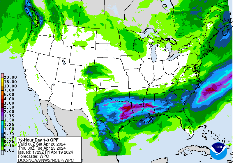
NOAA QPF- precipitation potential map depicts the possibility of 10 or more inches of rain in localized pockets along the northern Gulf Coast.
Keep in mind that "weaker" tropical cyclones, such as minimal tropical storms, often generate heavier rainfall totals than better developed tropical storms and hurricanes. This is counterintuitive to most people, as we may assume that all hazards are worse during higher "category" cyclones. However, weaker tropical storms are not as well developed vertically so they do not tap into the upper level steering winds that would generally give them a faster forward motion. So they tend to stick around for awhile.
The biggest concern is in areas that observe "training" of persistent rain bands well to the east of the center of circulation.
Gulf Coast residents should be well aware that we do not need a strong tropical storm or a hurricane to generate substantial flooding. Last August, a hybrid tropical low that was an unnamed storm dumped more than 30" of rain in portions of South Louisiana near Baton Rouge.

Residents in South Louisiana are still cleaning up from this catastrophic flood, which inundated tens of thousands of buildings. Last month I drove through Denham Springs, Louisiana, one of the worst impacted areas, and was saddened to see many people still cleaning up and living in trailers on their property.
Let's hope the forecasted heavy rains do not repeat flooding in these hardest-hit areas.
Cool stuff you have and you keep overhaul every one of us
ReplyDeleteYou have done a amazing job with you website
water extraction leak detection