Main Points
1) Hurricane Florence has intensified to a category-4 hurricane and will likely maintain category-4 strength as it approaches the Carolinas;
2) Florence will generate a large storm surge near and to the east of the landfall location;
3) Wind, rain and storm surge impacts will increase through the day on Thursday...landfall is likely Thursday night or early Friday;
4) Global weather models agree that Florence will slow down and drift. There is still considerable uncertainty in the timing and location of Florence stalling. If the drift occurs near the coast or offshore, the geographic extent and magnitude of storm surge flooding could increase dramatically;
5) The truly extraordinary and most catastrophic impacts of Florence will likely come from days of torrential rain near and well north of Florence's center from Thursday through early next week. Regardless of the exact track and intensity, extraordinary rainfall totals could impact locations from South Carolina through Pennsylvania/ New Jersey causing a widespread catastrophe.
Action Points
1) If you live along East Coast, from South Carolina through Pennsylvania, stay tuned to the National Hurricane Center, National Weather Service and your local media outlets for updated information. Florence threatens to inflict a widespread catastrophe.
2) I created a Facebook group yesterday to enable people threatened by Hurricane Florence to connect with survivors from previous floods. People are sharing lessons learned here- covering everything from evacuation to mold remediation. Click here to go to this group.
2) I created a Facebook group yesterday to enable people threatened by Hurricane Florence to connect with survivors from previous floods. People are sharing lessons learned here- covering everything from evacuation to mold remediation. Click here to go to this group.
Meteorological Analysis in Detail
Florence has intensified to a category-4 hurricane and is forecast to maintain that intensity through landfall. The storm will increase in forward speed and approach the Carolinas over the next two days. The latest National Hurricane Center (NHC) advisory is shown below.

Latest advisory from the National Hurricane Center
Florence will be tracking over a large region with favorable conditions to support a category-4 hurricane or even strengthen to category 5. Wind shear remains relatively light in this region and Florence is forecast to track over a large area where sea surface temperatures reach 86 degrees F (30 degrees C). The image below, adapted from a tropical cyclones website at the CIMSS/ University of Wisconsin, depicts this large area of warm waters over which Florence will traverse.

Florence's Storm Surge Potential
Florence threatens to generate a large and destructive storm surge near and to the east of the landfall location. Given the morning NHC advisory, this region will most likely occur along the North Carolina coast.
Major (category 3 and 4) hurricanes in the Carolinas have historically generated storm surges in the 15-20 foot range. Hurricane Hugo (1989) made landfall as a category-4 hurricane and generated a 20-foot storm tide (surge + tide) above Mean Sea Level (MSL) in South Carolina. Hurricane Hazel (1954) made landfall as a category-4 hurricane near the border of North Carolina and South Carolina and generated a storm tide of 18 feet above Mean Low Water, but when this is converted to height above MSL is reduces to 15-16 feet. Hurricane Fran (1996) made landfall as a category-3 hurricane in this same region and also generated a 15-16 foot storm tide.
Storm tide maps of these three events are shown below:


Although category-4 hurricanes in this region generate large, destructive storm surges, Florence has two characteristics that may serve to somewhat limit storm surge flooding compared to other storms with comparable intensities.
Characteristic #1: Fast Forward Motion
Florence is moving forward at 15 miles per hour and this rate will likely increase over the next two days. Fast-moving hurricanes have less potential to generate storm surge than slow moving hurricanes, because it takes time for strong winds to displace massive amounts of water.
This characteristic has one major caveat, however. The models are uncertain about the timing and location of Florence's stall, and last night's European model run suggests the stall could begin offshore. If the stall occurs offshore, this will serve to dramatically increase the storm surge magnitude and geographic extent of coastal flooding.
Characteristic #2: Relatively Small Wind Field Compared to Historic Hurricanes in Region
A second factor that may limit the magnitude and geographic extent of Florence's storm surge is the relatively small wind field, at least compared to historic hurricanes that have impacted the Carolinas. I was lead author on a paper that found the radius of pre-landfall 50-knot (58 mile-per-hour) wind fields correlated better with storm surge heights than other wind fields.
As Florence approaches the coastline, the NHC forecasts the radius of 50-knot winds to extend 80 nautical miles (nm) to the northeast. This extent of 50-knot winds is nearly half the extent observed in both Hugo (1989) and Fran (1996), which both generated 50-knot winds to extend 150 nm from the center of circulation.


Smaller wind fields can limit both the total magnitude and geographic extent of storm surge inundation, because strong winds reach the coast later than hurricanes with large wind fields. Also, strong winds in larger storms are displacing water over a greater area than smaller storms.
If the NHC's size forecast holds and Florence can make it through landfall without stalling, I expect Florence could generate a localized storm surge level of approximately 14-16 feet east of the landfall location, but surge levels could taper off quickly outside this area.
However, global models suggest that Florence's size could increase as it slows down, so if the stall and drift take place offshore, these size estimates could change dramatically. Florence is a powerful and dangerous hurricane and interests from South Carolina through the mid-Atlantic states should be on guard for coastal impacts.
Florence's Stall and Drift
Global weather models agree that Florence will likely stall and drift later in the week. The timing and location of this stall is still quite uncertain.
If this stall occurs while Florence is centered near the coast or just offshore, it will increase the storm surge extent and impacts dramatically. Monday evening's European model run forecasts Florence's stall to begin offshore. The images below show the unthinkable- Florence making landfall on Thursday evening (top image).....and Florence still making landfall on Friday evening (bottom image).


The European model run from Monday evening depicts Florence's stall starting offshore....with the storm making landfall on Thursday evening (above) and still making landfall Friday evening (below). Images courtesy: Tropical Tidbits/ Levi Cowan
Regardless of where the stall takes place, the truly extraordinary impact from Florence will come from days of torrential rain near and far north of the storm's center. These impacts could extend as far north as Pennsylvania and New Jersey.
Unfortunately, this summer has been unusually wet along much of the East Coast, and soils are already saturated in many areas- particularly in Virginia, Maryland and Pennsylvania.
Prolonged onshore winds will fill Chesapeake and Delaware Bays to capacity, slowing the drainage of heavy rainfall across a broad area.
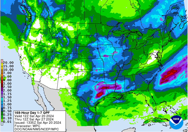
Florence threatens to take us into unknown territory. NOAA's Quantitative Precipitation Forecast (QPF) shows the potential of 10 or more inches of rain across a broad area from eastern North Carolina through much of Virginia over the next seven days, but these values could increase dramatically as this event unfolds.

It is common for QPF maps to start with a broad forecast of rain potential on a conservative basis. Much of the flooding from hurricanes can be localized from training of squalls over the same areas, and these localized maximums are unknown at this point and cannot be accurately forecast.
Last year during Hurricane Harvey, early precipitation forecasts depicted a large area of rain exceeding 15 inches.....in the end, training of rain bands over the same area generated rainfall totals exceeding 50 inches in the most extreme areas.
It's certainly possible that Florence's rainfall totals could exceed 25 inches to the north of where the system stalls out. This scenario threatens to inflict an unprecedented catastrophe across a widespread area.
REFERENCES
Harris, D.L., 1963. Characteristics of the Hurricane Storm Surge. United States Weather Bureau, Technical Paper No. 48.
This comment has been removed by the author.
ReplyDelete