BIG PICTURE
Hurricane Dorian should intensify today and tomorrow and become a major hurricane (cat 3) on Friday. Dorian is expected to make a westward turn on Friday and Saturday, and approach the Florida Coast late in the weekend or early next week. Considerable uncertainty in the track remains, and the entire Florida Peninsula is still in the "cone of uncertainty". A stronger version of Dorian could track farther to the south and a slightly weaker version track farther north. Regardless of the exact landfall location, Dorian could inflict severe wind and storm surge impacts related to landfall, and then possibly prolonged flood impacts north to Georgia and the Carolinas next week.

IN DETAIL
It helps to think of Dorian's development and impacts in four distinct phases:
PHASE NAME TIMING
PHASE I INTENSIFICATION THU PM - FRI
PHASE II TURNING FRI - SAT
PHASE III COASTAL IMPACTS SUN - TUE
PHASE IV PROLONGED FLOODING TUE - THU
PHASE I: INTENSIFICATION
THU PM - FRI
Dorian's maximum sustained have held at 85mph for the past 12 hours. Some moderate wind shear associated with an upper level low to the west has been impeding Dorian from intensifying. This upper level low should back off later on Thursday, enabling Dorian to strengthen. The National Hurricane Center forecasts maximum sustained winds will increase to 100mph by this evening.
Dorian should then track through a very favorable environment for intensification, as low wind shear, warm sea surface temperatures and a moist environment enable Dorian to likely become a major hurricane (cat 3) on Friday.
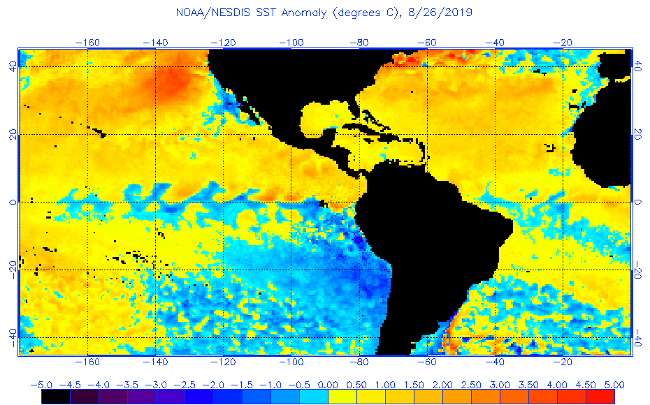
The sea surface temperatures along Dorian's entire forecast path are consistently running warmer than normal. The map above from NOAA/ NESDIS shows the massive extent of warm sea surface temperatures throughout the entire Main Development Region (MDR) of the western North Atlantic basin. These warm waters play a role in Dorian's intensification because they provide the fuel hurricanes need to develop.
An upper level ridge should start building to the north or northeast of Dorian and encourage a turn towards the west on Friday and Saturday.
While the timing, position and strength of this ridge are somewhat uncertain, hurricane climatology reveals an important pattern for such situations. In general, a more powerful hurricane will "feel" the ridge earlier than a weaker hurricane, meaning if Dorian develops into a more powerful hurricane (cat 3-4) by Friday afternoon, it may make a sharper turn to the west than a weaker (cat 2-3) version of the same storm.

A stronger version of Hurricane Dorian would likely "feel" the steering of the upper level high pressure system sooner, giving the storm a track farther south.
This may explain, at least in part, the difference in landfall pressures between the latest runs of the American (GFS) and European models. This morning's GFS model showed an air pressure of 968 mb around the time of landfall, whereas yesterday evening's European model forecast a landfall pressure of around 959 mb, which may indicate a slightly stronger storm.

This morning's American (GFS) model run depicts a powerful hurricane with 968 mb central pressure approaching the central Florida coastline.

PHASE III: WIND/ SURGE IMPACTS
Dorian will likely inflict severe wind and flood impacts along the southeast U.S. Coastline. Although Florida may be the prime target right now, flood and wind impacts could extend into Georgia and South Carolina.
Initially, it looks most likely that Dorian will make landfall somewhere on the Florida peninsula. The late morning (11AM EDT) advisory from the National Hurricane Center indicates that that most likely track would take Dorian to near the Central Florida Coast by Monday morning, and wind speed estimates have bumped up to 130 mph, which would make Dorian a powerful cat-3 hurricane, approaching the cat-4 threshold.

I ran some historic storm surge maps this morning to look for guidance from analog/ historic hurricanes that have approached Florida's Atlantic Coast. Considering Dorian's forecast in light of historic observations, the best general guidance I could come up with, based on the current track and intensity forecast, is a storm surge level of 11-13 feet.
I think it's likely for a more powerful version of Dorian to track farther south, but coastal dynamics in southeast Florida are not as conducive for storm surge development as northeast Florida. Therefore, a category 3 hurricane making landfall in northeast Florida, may generate comparable, or slightly higher, storm surge levels than a category 4 hurricane striking southeast Florida.

The coastal profile of northeast Florida, Georgia and South Carolina enhance storm surge levels in this region. Comparable hurricanes will generate higher storm surge in northeast Florida than southeast Florida.
If we look closely at the NHC advisory, we see an interesting detail that has emerged. Look at the reduced forward motion after landfall on this advisory. According to the map, Dorian would make landfall late morning on Monday and the center of circulation would be near Orlando at 8AM Tuesday.
We should not focus on specific locations and timing at this point, but use this insight to see the bigger picture. The NHC forecast is hitting on something also seen in the American and Euro models- it appears that Dorian will slow down dramatically, and make a turn towards the north or northwest around or after landfall.
Given the high uncertainty in the forecast at this time, it is also possible that this turn could happen before landfall, taking Dorian on a track towards Georgia or South Carolina. Although it is too early to know these details, all interests from South Florida through South Carolina should prepare for potential severe wind and flood impacts.

I have increased the likelihood of substantial damage from wind and flood impacts for all three hazards on the Hazard Area Likelihood (HAL) Index today. Substantial wind and flood impacts are now probable for all hazards.
The trend for Dorian to slow down dramatically early next week is of great interest, and heightens the drama of this storm. If the slow down or stall happens around or after the time of landfall, it will greatly exacerbate flooding from both storm surge and rainfall....whereas if it occurs before landfall, it could possibly keep Dorian offshore and diminish flood risk.
I am here now and just want to say thank you for a tremendous post and an all-around entertaining website. It is an extraordinary site you have here…I sincerely acknowledge BLOGGERS like you! birthday message for mother long distance
ReplyDeleteไม่มีฝากขั้นต่ำ ระบบบริการสำหรับเล่นสล็อตออนไลน์ รวดเร็ว ปลอดภัย เชื่อถือได้ เป็นอีกระบบบริการอย่างหนึ่งของเรา สมัครที่นี่ ที่มอบความสะดวกสบายให้กับนักเล่นเกมสล็อตออนไลน์ทุกท่าน
Delete