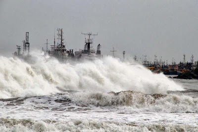
Tropical Cyclone Phailin generated a large storm surge and destructive waves along the coast of India. Image source: http://www.abc.net.au/news/image/5018642-3x2-940x627.jpg
That said, a few observations are just starting to come in...
An article from the BBC states...
"The Times of India reported that a storm surge more than 3m (9ft) high had inundated areas of Ganjam, Khurda, Puri and Jagatsinghpur districts of Orissa and the Srikakulam district of Andhra Pradesh." See: http://www.bbc.co.uk/news/world-asia-india-24510464
Also, the closest INCOIS tide gauge, located in Paradeep, which is well east of the area of peak surge, has reported surge levels exceeding one meter. The graphic below provides water levels from the past 24 hours. The top graphic depicts observed water levels (dots) compared to astronomical tide levels (if there were no storm). The difference between these two levels is essentially a storm surge, and often called a residual, on such graphs.
Note that between 0900 and 1000 UTC, some residual levels exceeded 1.5 m. However, these high values may include some wave action, so they may not be purely storm surge levels.
Observed water levels vs. astronomical tide levels for the past 24 hours at Paradeep, India. Source: http://tsunami.incois.gov.in/ITEWS
Residual water levels from the past 24 hours at Paradeep, India. These levels represent the difference between observed water levels and astronomical tide levels, and essentially represent storm surge observations. Source: http://tsunami.incois.gov.in/ITEWS
Please send any storm surge observations from this storm to me by:
1) Replying to this or other blog posts
2) Sending me a tweet at @hal_needham
3) Emailing me at hal@srcc.lsu.edu
Thank you so much and stay safe, everybody!
-Hurricane Hal


No comments:
Post a Comment