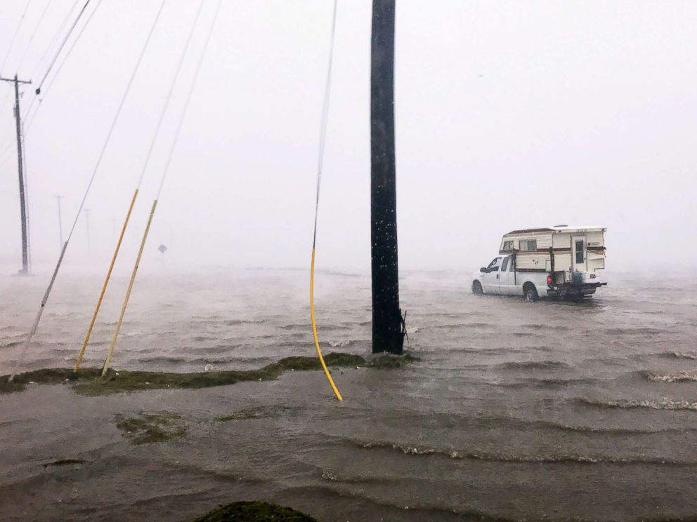
Highest Surge
Harvey's highest storm surge occurred east of Rockport. We should expect a long-term, severe storm surge as far east as Matagorda Bay, where strong onshore winds are continuing to push a substantial storm surge into places like Port Lavaca.
A NOAA Tides and Currents gauge at Port Lavaca, Texas, reported an observed storm tide level of 7.0 feet above Mean Sea Level (MSL) at 3:48AM Central Time. Unreported storm tides in this region likely reached as high as reached 10-12 feet.
Port Lavaca
Harvey has generated the highest storm surge at Port Lavaca since Hurricane Carla (1961). However, Harvey's storm surge level in this area is not as rare as we might believe, and it may come in 5th place for all surges since 1919. What's exceptionally rare about Harvey is that this storm surge will combine with a stalling storm and tremendous rainfall, which will generate catastrophic flooding.

Compound Flooding
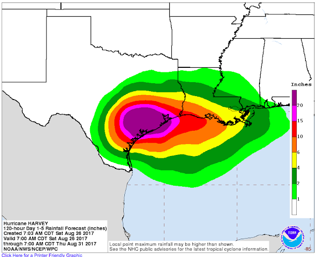
To the east of the storm center, onshore winds will keep storm surge levels elevated and impede the drainage of heavy rainfall. This will be a major problem, as Harvey is forecast to dump 20 or more inches of rain across a widespread area over the next week.
Highly Variable Storm Surge Levels
Storm surge levels closest to Harvey's center of circulation will be highly variable, depending upon wind direction. As Harvey is forecast to drift for several days, a change in the center of circulation by even a few miles can change the wind direction from offshore to onshore in places. Areas closest to Harvey's circulation center may see rapid water level rises and falls as wind direction changes from offshore to onshore, and vice-versa.
For example, the storm surge level was about 1 ft below normal at Rockport around 2:00AM today, but then began rising rapidly to around 0.8 ft above normal by around 3AM, when the tide gauge failed.

Houston/ Galveston/ Freeport
Farther east from the center of circulation, around the Houston/ Galveston/ Freeport areas, expect persistent onshore winds with strong squalls today. The squalls will likely be separated by periods of multiple hours with no rain. Depending on Harvey's track, onshore winds and rainfall may increase in this area from late Sunday through Tuesday, which would increase flood potential.
Tornadoes most often are spawned in these bands well east of the circulation. Hurricane Carla (1961) made landfall in the Port Lavaca region, but generated several powerful tornadoes that caused substantial damage in Galveston.

If Harvey tracks northeast after stalling, the threat of strong onshore winds and heavy rainfall will increase in this region. Prolonged onshore winds even below tropical storm force could elevate places like Galveston Bay by several feet for multiple days. Even a modest storm surge in this area could exacerbate flooding, as a prolonged storm surge of 2-4 feet in Galveston Bay will impede the drainage of torrential rainfall.
Larger Perspective on Coastal Flooding and Extreme Events
Harvey has struck an area that has observed multiple major hurricane strikes and storm surge events in the past century. Prior to Harvey, four hurricanes have generated storm surges of at least 13 feet at Port Lavaca, but none since Hurricane Carla (1961), 56 years ago.
Harvey is a classic example of why we need to know our hurricane history. From a storm surge perspective, this event may seem exceptional along the Central Texas Coast, but in the bigger picture it may end up more like a 20-25 year storm surge event (surge level we should expect every 20-25 years on average). Again, what is truly exceptional about Harvey is the likelihood of it stalling and dumping tremendous rainfall, which will be coupled with a long-term storm surge.
Harvey is striking one of four areas along the U.S. coastline that concern me because they have observed severe hurricanes and storm surges in the past, but not in recent history. Here are the areas that concern me most:
1) Georgia and Southern South Carolina:
This area observed hyperactive hurricane strikes and severe storm surges in the late 1800s, but nothing of that magnitude since 1898. The area south of Charleston concerns me the most, because they were on the "weak" side of Hurricane Hugo (1989) and did not experience Hugo's massive surge.

2) Palm Beach/ Fort Lauderdale, Florida:
This area observed large surges in 1928 and 1947 and has had many near misses. Hurricanes Frances and Jeanne, both in 2004, made landfall just north of this region, keeping it on the weaker side and forcing the strongest winds to blow offshore. Hurricane Andrew (1992) was a powerful, but geographically compact hurricane the made landfall south of Miami and did not generate substantial surge in Fort Lauderdale or Palm Beach.

3) Florida West Coast, especially Tampa/ St. Petersburg:
This area is setup for a massive storm surge event with an astronomical impact because the bay is highly developed, with relatively minor flood protection. Storm surge models suggest a surge exceeding 20 ft (6.1 m) could strike the bay, if a hurricane tracked in from the southwest and made landfall north of St. Petersburg/ Clearwater.
Two hurricanes struck the area in 1848, both generating surges that exceeded 10 ft. The last substantial storm surge in this region occurred in 1921, when a hurricane generated a 10.5 foot surge.
4) Central Texas Coast:
Hurricane Harvey is currently striking the fourth region that concerns me.
Port Lavaca had observed four storm surges exceeding 13 ft in the past century, but nothing higher than 6.9 ft since 1961.
Corpus Christi, the largest city along the South-Central Texas Coast, shares a disturbing history of hurricanes and storm surges. The city has observed seven storm surges that have exceeded 7.9 ft in the past 102 years, or about 1 surge every 15 years over that threshold. But none of them have occurred in the past 37 years, since Hurricane Allen in 1980.

Long periods of relative calm often lead us to underestimate our risk.
As I told a reporter on the phone yesterday, our foremost problems are public perception and lack of awareness. Once we truly understand our risks, widespread support for coastal protection rapidly increase, and funding these projects follows.
Notes: I usually write well-referenced articles, but as Harvey is impacting our area, I do not have time to add references/ citations right now to this blog. If you have any questions about Harvey or anything related to coastal flooding in general, shoot me an email and I will try to get back to you ASAP.
For the most frequent updates, check out the U-Surge Hurricane Harvey page: https://www.u-surge.net/hurricane-harvey.html.
Thunder starting again and lights flickering, so I guess that means I'm done here!
I hope I can access email on my phone.... contact me at: hal@marineweatherandclimate.com
Stay safe, much love, and thanks for reading!
-Hal
Thanks for sharing this news with us. Amazinsilk and Same day tour | Agra tour
ReplyDeleteHurricane Hal'S Storm Surge Blog: Perspective On Harvey'S Storm Surge And Widespread Flood Threat >>>>> Download Now
Delete>>>>> Download Full
Hurricane Hal'S Storm Surge Blog: Perspective On Harvey'S Storm Surge And Widespread Flood Threat >>>>> Download LINK
>>>>> Download Now
Hurricane Hal'S Storm Surge Blog: Perspective On Harvey'S Storm Surge And Widespread Flood Threat >>>>> Download Full
>>>>> Download LINK t8
our post has given very valuable information, keep posting the same information like this always. What a great tour and visit! Grand Indian Tours
ReplyDeleteThanks for all the great advice. It is something I would really like to experience one day. This was an encouraging article to read.
ReplyDeleteSame day Agra Tour By Car
Sunrise Taj Mahal Tour by car
Same day Taj Mahal Agra Tour By Car
Taj Mahal tour by car
Shimla Family Tour Package
What a fantastic post you shared. Thank you so much for sharing this post myself anubhav from Agra, India. We have a tour operator company by the name of Padma Holidays. Our company provides best tour packages / services to our valuable Guests
ReplyDelete