Good evening everyone-
Well, Irma is on her way, and starting to slowly turn towards the NW towards the Florida Keys.
I am writing this blog post from Winnie, Texas. Around 12 days ago, Winnie looked like it was under the ocean, complete with white capped waves moving across I-10.

Somehow the town has bounced back quite rapidly from Harvey's flooding.
But the focus tonight is Irma. I have received a lot of questions while on the road today. I wanted to reply to the main themes as soon as possible.
If you scroll through my blog, I usually try to combine science writing with pics/ graphics to communicate about storm surge/ coastal flooding science.
Tonight, in the interest of time and to accommodate my travel schedule, I am just writing text. Here are the main themes I want to address:
1) How do you feel about the storm surge forecast for Florida's Atlantic Coast now that Irma has drifted farther west?
Although Irma has drifted west, the wind field is still rather broad- hurricane force winds extend 70 miles from the center of circulation and tropical storm force winds out to 195 miles. This wind field is broad enough to push some storm surge on Florida's Atlantic Coast. The NHC forecasts 2-4 feet of storm surge from North Miami Beach to near the Georgia border, and this seems like a reasonable storm surge level for places like Jax Beach, St. Augustine, Daytona Beach, Melbourne, Jupiter, Palm Beach and Fort Lauderdale.
2) If Irma's storm surge reaches 12 feet in Naples and my house in Naples is 10 feet above sea level but inland 1-2 miles, will I flood?
If given enough time, a 12-foot storm surge will inundate everything under 12 feet with salt water. Storm surge can flow inland quite rapidly, but surge needs at least several hours of strong onshore winds to get pushed inland. In general, if your property is located within 2-3 miles of the coast, the surge level will reach its elevation contour.
Keep in mind that waves can travel on top of the storm surge and this is not included in the storm surge forecast. Areas exposed to a bay or ocean will often observe waves of at least 1-2 feet during a hurricane (and often times higher wave heights).
3) If my house is elevated above the storm surge level, am I in danger?
This is a bit complex. If storm surge lasts for a long enough time it can impede rainfall drainage and lead to "compound flooding". Also, if accompanied by strong onshore winds, storm surge flows inland rapidly like a "river of water." This can cause some houses to fail, even if the first floor elevation is higher than the peak surge level. But in most cases, if your first floor is elevated above the storm surge level you will not flood.
4) What is the storm surge potential in the Florida Keys?
The NHC is predicting 5-10 feet of storm surge in the FL Keys. This seems reasonable for the Upper and Middle Keys, but if the eyewall makes landfall in the western Keys, I would expect some local peak values to reach the 10-12 foot range. Last night I was predicting peak surge levels in the Keys to reach as high as 14-16 feet, but the best forecast on Irma's track and intensity kept it over the Florida Straits (not landfall in Cuba) and maintaining intensity around the cat 4/5 threshold. Irma is now tracking towards the western FL Keys as a category-3 hurricane.
Hurricane Donna (1960) and Irma are fairly similar in size and intensity, but Donna may end up crossing the Keys a bit more intense than Irma. Donna generated at least five storm tide (storm surge + tide) levels exceeding 12 feet, with a storm maximum storm tide of 13.7 feet at Tavernier. Irma's peak surge should be farther west, but I would not rule out a 10-12 foot peak storm surge in the Lower Keys, if the eastern eyewall crosses an island.

5) Would you feel comfortable riding out the storm in/ near Naples?
I would not feel comfortable staying near Marco Island, Naples, Fort Myers, or frankly any coastal town south of Tampa. If not for the devastating storm surge in places near and east of landfall, the maximum sustained wind speeds in this region could reach the 125-140 mph range. Most people do not realize the danger of these wind speeds. What they are picturing happens at 125-140 mph really happens in the 60-70 mph range....numerous tree falls, power outages, building shaking. A maximum wind speed of 130 mph is twice as high as 65 mph, but has four times as much force.
6) What about the storm surge threat along the Georgia coast?
The NHC is predicting a 4-6 ft storm surge from SC through extreme NE Florida, including the entire Georgia coast. This prediction seems reasonable. Keep in mind that the distance from the NE Gulf of Mexico, near Cedar Key, to coastal Georgia, is less than 150 miles, so Irma could be centered in the NE Gulf of Mexico and generating tropical storm force winds along the Georgia Coast. See #8 below for discussion about the prolonged surge event likely along Georgia coast.
7) Will the storm surge just go into the local bay/ inlet and miss our community?
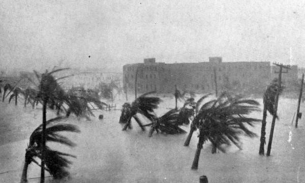
Storm surge is generally a "dome" of water that inundates the entire coastline. Many people picture it more like "tsunami wave" that quickly comes and goes, and hopefully will wash somewhere else.
The picture below is from Miami during the Great Miami Hurricane of 1926. It's one of my favorite storm surge photos because it clearly shows the "dome of water" inundating the landscape and leaving just the tops of palm trees emerging from the water.
The storm tide level in this event reached 15 feet, which is near the upper maximum that the NHC is predicting for SW Florida, including the Naples region. A storm surge of this level will move inland for many miles, inundating everything in its path.
8) How long with the storm surge last?
Storm surge is quite variable in height and timing, depending on the local geography and proximity to the hurricane eye. In general, storm surge will last as long as onshore winds persist. In the Keys and FL west coast, the longest-duration surge events in Irma will occur in the FL Keys- particularly for E or SE facing coastlines.....for SW Florida in locations east of landfall (perhaps Marco Island and Naples).
Along the Atlantic Coast, storm surge levels should be more moderate, but onshore winds will persist throughout the event, keeping a low-moderate surge persisting for more than one day. This may be a problem in places like coastal Georgia, where a 4-6 ft storm surge can be expected, with elevated water levels likely exceeding 36 hours.
This creates a problem with "compound flooding", when prolonged storm surge impedes rainfall drainage. In a compound flood event, an area may flood from 10 inches of rain, when in similar rainfall events the location did not flood. Places like Savannah may observe compound flooding.
9) What about the Florida Panhandle?
The Florida Panhandle should stay to the west of Irma's track, meaning strongest winds should blow offshore and minimize surge levels.
10) How does the storm surge timing relate to the hurricane landfall?
Storm surge timing is location-specific, but we generally need a strong onshore wind to generate storm surge. Peak storm surge levels often accompany the arrival of the eyewall, but if tracking shore-parallel, like in portions of western FL, the peak storm surge will occur after the eye passes and winds shift direction, blowing from the west.
11) I saw pictures of ocean water getting "sucked" out of islands in the Bahamas. Will that happen in Florida?
Water basically obeys the commands of the wind. When wind is blowing strong offshore, water will get pushed out of bays. This will happen in places like Tampa Bay, as Irma approaches from the south. Expect low water levels that expose extensive mud flats. Immediately after the passage of the eye, intense winds from the west, will bring the normal water level back and rapidly generate a storm surge as well. Even if surge levels only reach 3-6 feet near Tampa, expect dramatic swings in water flow direction and water levels.
12) Could Irma just keep drifting west and miss the Keys/ SW Florida? and/or
I've lived in SW Florida for many years and hurricanes usually seem to miss us at the last minute? What is the chance that Irma will miss us too?
A common perception in SW Florida is that hurricanes will turn and miss certain communities. I've heard this sentiment in Siesta Key, near Sarasota, as hurricanes Charley (2004) and Wilma (2005), both made landfall south of this region, leaving them on the "weak side".
I would expect that sentiment to exist around Naples as well. Hurricane Charley made landfall around Punta Gorda, and intense winds impacted areas as far south as Fort Myers, but Charley was a compact storm and Naples emerged with minimal damage from Charley.

Wilma made landfall south of Naples, leaving the city on the "weak side"....while generating a storm surge approaching 16 feet near the SW Everglades. People in cities that observe several "near misses" often begin to assume that something in the local geography protects them from hurricane strikes.
A big difference between Charley/ Wilma and Irma is that Irma is Irma is taking a shore-parallel track, while Charley/ Wilma took more shore perpendicular tracks. Shore-perpendicular hurricanes leave some communities as "winners" when they turn or shift their track, but shore-parallel hurricanes don't "miss" that much, especially if they have extensive wind fields.
Irma is producing hurricane-force winds for 70 miles from the center of circulation and is forecast to track close to the western FL coast. So even if Irma's track shifts 30 miles in either direction, most coastal towns from Naples to Cedar Key, including the Tampa/ St Pete metro area, will likely observe hurricane force winds.
13) Are there any areas where you feel the "official" forecast may be inaccurate?
The official NHC forecast seems to match historical/ empirical context pretty well. One area I have felt the official forecast has been underestimating is the peak surge level in the FL Keys, which I think could reach 10-12 feet.
Storm surge forecasting is tricky, because slight changes in the hurricane track can lead to big differences in storm surge levels. Irma is forecast to track near the west coast of FL as far north as Cedar Key and generally produce a storm surge of 4-6 feet north of Clearwater. If Irma tracks along the western edge of the forecast cone, and stays offshore north of Clearwater, we can expect storm surge levels to reach as high as 6-9 feet in places like Cedar Key.
It's hard to make an exact prediction right now with some uncertainty in the exact track.
Well I successfully finished a blog post with almost all text....which I hate to do.
Under my personal circumstances, it was text or nothing tonight, so please bear with me and hopefully I'll include more visuals soon.
Take care everyone and stay safe! Please email me at hal@marineweatherandclimate.com with any questions or request for media interviews.
Good night!
-Hal
อย่างที่ทราบดีว่าเกมสล็อต PG มีเกมมาให้เล่นอยู่เป็นประจำ ก็เลยได้มีบริการ ทดสอบเล่น สล็อต pg มาใหม่ เพื่อความร่าเริงที่เล่นอย่างมั่นอกมั่นใจ ทดลองเล่น สล็อต pg มาใหม่ ทดลองเล่นก่อนได้เลยไม่จำเป็นที่จะต้องใช้เงินลงทุน ทุกสมาชิกของเว็บไซต์ จะได้โอกาสได้เล่นเกมสล็อตมาใหม่จากค่าย PG SLOT ก่อนใครกันแน่
ReplyDeleteมวยพักยก จะให้มือใหม่ได้ตรวจสอบและลองใช้งานได้จริง ตั้งแต่ปากทางเข้าใช้งาน การเลือกคู่ที่อยากได้แทง
ReplyDeleteลีนไทย ราคาขายส่ง หาซื้อง่าย ผสมกับอะไรก็เหมาะ อย่างพอดี
ReplyDeleteตอนนี้การดื่มลีนมีความนิยมชมชอบอย่างมากมาย โดยเฉพาะอย่างยิ่งการดื่มลีนไทย ที่มีการผลิตมาจากไทยแท้ รสมากมาย ทั้งยังหาซื้อได้อย่างง่าย คอยของไม่นาน ประสิทธิภาพเท่ากันกับลีนนอกชั้นแนวหน้าสุดยอด ก็เลยทำให้วัยรุ่นไทยต่างทุ่มเทใจให้กับการดื่มลีนของไทยกันเยอะมากๆอย่างยิ่งจริงๆ เพราะฉะนั้นในวันนี้ถ้าคุณเป็นมือใหม่ด้านแวดวงลีน LEANBKK จะพาทุกท่านมาทำความรู้จักการดื่มลีน ให้รู้เรื่องกันเยอะขึ้น NEO-K FORTE SYRUP
https://jbothai88.org/
ReplyDeleteรวมกีฬายอดนิยมที่เปิดให้เดิมพันบน JBOThai88 JBOThai88 รวมกีฬาเด็ดจากทั่วทุกมุมโลก มาให้คุณได้ลุ้นแบบจัดเต็ม พร้อม อัตราต่อรองสุดคุ้ม ค่าน้ำดีที่สุด และตัวเลือกเดิมพันที่หลากหลาย
Promethazine เป็นยาแก้แพ้ที่ออกฤทธิ์โดย{การยับยั้ง|การขัดขวาง|การหยุดยั้ง}สารฮีสตามีนที่ร่างกาย{สร้างขึ้น|ผลิตขึ้น|ทำขึ้น}เพื่อกำจัดสารก่อภูมิแพ้ ใช้{บรรเทา|ทุเลา}อาการจากการแพ้ {เช่น|อาทิเช่น|ตัวอย่างเช่น|อย่างเช่น|ดังเช่น|ดังเช่นว่า|ได้แก่|เป็นต้นว่า|ยกตัวอย่างเช่น} คัน น้ำมูกไหล จาม {ลมพิษ|ผื่นคัน} {และ|และก็|แล้วก็|รวมทั้ง}ผื่น
ReplyDeletewww.dr-vips.com/th
หนังญี่ปุ่นคุณภาพ ทั้งอนิเมะและไลฟ์แอคชั่น
ReplyDeletehttps://www.pinterest.com/bizg22/_profile/
หนังเข้าโรงล่าสุดวันนี้ – รวมลิสต์หนังโรงที่กำลังฉายอยู่ตอนนี้ - https://www.pinterest.com/siamsyrup/_profile/
ReplyDeleteหนัง Netflix น่าดู https://coub.com/siamsyrup01
ReplyDeleteหนังแอคชั่นมันส์ ๆ https://www.producthunt.com/@siamsyrup
ReplyDeleteหนังสยองขวัญ ห้ามพลาด https://coub.com/siamsyrup01
ReplyDeletehttps://www.pinterest.com/pod49/_profile/ จำหน่าย ผลิตภัณฑ์พอต Marbo ทั้งแบบกลิ่นผลไม้ กลิ่นมินต์ กลิ่นขนม
ReplyDeleteจำหน่าย ผลิตภัณฑ์พอต Marbo ทั้งแบบกลิ่นผลไม้ กลิ่นมินต์ กลิ่นขนม https://www.pinterest.com/pod45554/_profile/
ReplyDeletehttps://www.producthunt.com/@pod49
ReplyDelete“หาซื้อพอต Marbo รุ่นใหม่ล่าสุด มีหัวพอตสำรองและน้ำยาให้เลือกหลายรสชาติ”
https://www.producthunt.com/@baskara_putra “หาซื้อพอต Marbo รุ่นใหม่ล่าสุด มีหัวพอตสำรองและน้ำยาให้เลือกหลายรสชาติ”
ReplyDeletehttps://www.cheaperseeker.com/u/rismotv แหล่งรวมของเล่นใหม่สายเขียว.
ReplyDeleteควันนุ่ม กลิ่นหอม: ประสบการณ์ที่ NEW BONG มอบให้.
แอดไลน์เพื่อรับส่วนลด 10% ทันที!
https://www.cheaperseeker.com/u/santi420 สวรรค์ของสายเขียวตัวจริง! พบกับ พันธุ์ OG Kush แท้ และสายพันธุ์ยอดนิยมอื่นๆ
ReplyDeleteปลูกแบบออร์แกนิก ให้คุณเลือกสรร บ้องดินเผา และอุปกรณ์ครบชุด ดีไซน์เอกลักษณ์ เพื่อการสูบที่นุ่มนวล จัดเต็มทุกอารมณ์!
BANG OG: สายพันธุ์ OG แท้! ออร์แกนิก เลือกบ้องดีไซน์เอกลักษณ์ จัดเต็ม!
https://speakerdeck.com/bangog แหล่งรวมความสงบและสุนทรียภาพ! บริการ กัญชาเกรดพรีเมียม พร้อม บ้องไม้ไผ่ทำมือ ที่เป็นมิตรกับสิ่งแวดล้อม
ReplyDeleteบรรยากาศร้านสุดชิล ให้คุณเพลิดเพลินกับการผ่อนคลาย ได้อย่างลงตัวและเป็นส่วนตัว แวะมาสัมผัส!