Storm Surge Levels May Have Reached 15 ft in the Lower Keys
An early, but unverified, report from Cudjoe Key, FL, appears to show a 15-foot storm surge. This would have been a likely location for peak storm surge in the Keys, as Irma tracked just west of here, keeping places like Cudjoe Key and Marathon on the "strong" side of the storm.

Irma passed east of Key West, generating powerful east winds as the eye approached. This pushed water away from the tide gauge, which sits at the western end of the island. As Irma tracked north, "wrap around" winds on the back side of the eye, produced strong west winds and increased surge levels on Key West. See tide gauge graph below, where the blue line is normal tide level and red is observed. The difference is the storm surge.
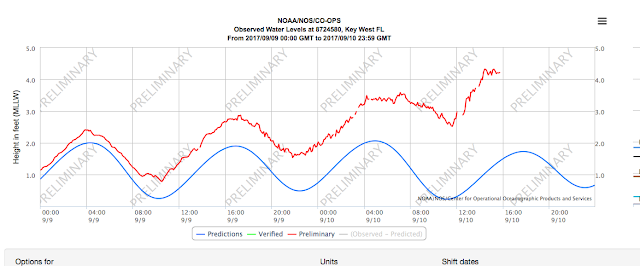
Water levels at Key West rose more rapidly after Irma made its closest approach and winds shifted to the west. Blue = astronomical tides, red = observed water level, difference = storm surge
Irma Closing in on Naples/ Marco Island Area
Irma is approaching the Naples/ Marco Island area. Unfortunately, it appears that the center of the eye will pass just west of these locations, enabling the eastern eyewall, the strongest part of the storm, to make a direct hit.
Throughout the storm, winds have been blowing from the east with increasing intensity in this region. Expect a sudden shift of wind direction from the south, rapid intensification of winds and a catastrophic storm surge to rapidly push into these areas over the next three hours.
If you stayed in Naples or Marco Island, the next three hours are all about survival. It's actually better for the eye of the storm to pass directly over your house than for it to track west of your house and leave you in the eastern eyewall.
If you must escape a flooded ground floor by going into an attic, make sure you take some water and an axe or something to break your way through the roof. Winds will persist from the west, keeping surge/ flood levels elevated for some time.

Where did all the water go?
Strong east winds have pushed water away from the coast to the north of Irma's center. This has caused "negative" surges in places like Fort Myers and Tampa, as water levels have rapidly dropped, exposing extensive mud flats.
Beware! This water will all rush back, with additional storm surge on top, as soon as the winds die down in the eye or change direction immediately after the eye passes. Expect wild changes in water levels all along the western Florida coast over the next 24 hours, with local changes occurring most rapidly near Irma's eye.
Click once to help your city!
Stuck inside and wish you could help your city in some way? You can! The U-Flood Project launched FloodMap to enable people like you to map flooded streets in real time.
It's so easy:
1) Go to this website: https://floodmap.io
2) Click on the image of your city
3) Click on a street to mark it as flooded
Even if you just mark the street in front of your house, the effort from thousands of users will generate a real-time map of flooding in your city. This provides crucial information to emergency services and enables the public to follow Irma's flooding.

Downtown Miami is starting to flood, according to this real-time map of flooded streets. Just click on a street to mark it as flooded.
Game of inches (or miles)
As Irma does a tightrope walk up the Florida Gulf Coast, a change of track by just a few miles will make a world of difference.
Worst case scenario is Irma's eye staying just offshore and the eastern eyewall engaging your community.
This will especially make a dramatic difference in storm surge levels.
Where the eyewall is generating powerful onshore winds, expect rapid and catastrophic storm surge to overwhelm the coast.
-Hal
thank you for sharing
ReplyDeleteviagra asli
viagra original
viagra asli usa
obat viagra asli
viagra original usa
jual viagra asli
cialis asli
ReplyDeleteobat klg
vimax asli
viagra asli
Thanks for sharing, nice post! Post really provice useful information!
ReplyDeleteGiaonhan247 chia sẻ kinh nghiệm trang web mua đồng hồ uy tín tại mỹ nhất hay những hạn chế dịch vụ mua hộ hàng mỹ hay dịch vụ mua nước hoa pháp và vận chuyển gửi hàng đi nhật cùng với dịch vụ mua hộ hàng mỹ uy tín đầy tiện ích.