
National Hurricane Center intensity and track map for Harvey.
Link: http://www.nhc.noaa.gov/storm_graphics/AT09/AL092017_5day_cone_no_line.png
Link: http://www.nhc.noaa.gov/storm_graphics/AT09/AL092017_5day_cone_no_line.png
MAIN POINTS

-Harvey likely to develop into a tropical storm today or tonight;
-All major models bring Harvey towards the Texas coast;
-Harvey may stall out near the coast or slightly inland;
-The most certain impact is major flooding from days of torrential rain and compound rain/ storm surge

Visible satellite image shows deep convection in the remnants of former Tropical Storm Harvey to the northwest of the Yucatan Peninsula.

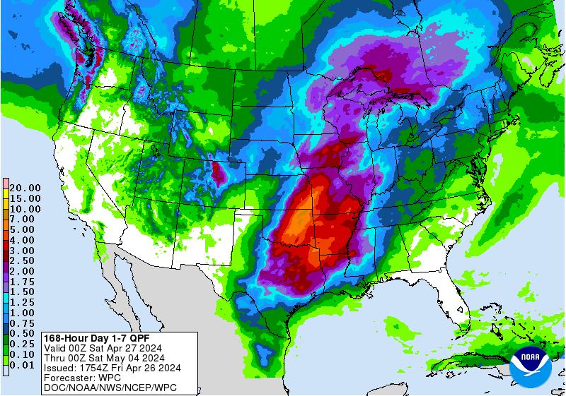
The Quantitative Precipitation Forecast (QPF) from the National Weather Service, issued at on Wed Aug 23 at 2:57AM Central Time.
The Quantitative Precipitation Forecast (QPF) from the National Weather Service, shown above, depicts 7-day rainfall potential exceeding 10" in a widespread area, including metro Houston, Freeport, Galveston, Beaumont and Lake Charles. This model shows a peak value of 16.5" near Galveston Bay.


Consider that Hurricane Isaac (2012), which was "only" a cat-1 hurricane, flooded some communities near New Orleans that did not flood in Hurricane Katrina. Isaac's main weapon was compound flooding, which inundated many communities around Lake Pontchartrain, like LaPlace (see pic above), forcing the rescue of nearly 4,000 people.
Harvey has the potential to set up a scenario like this in coastal Texas.
This is the big concern with Harvey. I’m particularly
concerned about places like Galveston Island, north of Broadway, and Pasadena,
Baytown, Laporte, Clear Lake, Kemah and Nassau Bay. If these areas get
torrential rains for days and the Bay is elevated, I just don’t see where the
water can go except into neighborhoods.
DETAILS
Timing: For the Houston/ Galveston/ Bolivar Peninsula region- expect wind and rain squalls to arrive by late in the day on Friday, however, there is too much uncertainty right now to pinpoint a time. Storm surge/ waves may start increasing in the Gulf and Galveston Bay by late Friday.
Duration: Most models show Harvey slowing down/ stalling
near the Texas Coast or slightly inland. This could mean that rain, wind and
surge impacts are felt from late Friday until Tuesday.
Impacts:
Risk of
Damaging Winds: Medium
Risk of
Power Outage: Medium
Risk of
Substantial Storm Surge (5 feet or higher): Medium-High
Risk of
Heavy Rainfall Flooding: High
AVOID LOOKING AT THE CATEGORY/ NUMBER
A lot of people are talking about what “category” Harvey
will be. They are referring to the Saffir-Simpson Hurricane Wind Scale, which
classifies hurricanes on a scale of 1-5. This category system is misleading and
people who make decisions based on the category are often shocked by unexpected
storm impacts.
The category is ONLY based on maximum sustained winds. It
says nothing about heavy rainfall potential. It says nothing about storm surge
potential.
Hurricanes and tropical storms throw three hazards at us-
wind, rainfall and storm surge. Think of the impacts separately. Storms with
weaker winds are more likely to stall and dump heavier rainfall. This shocks
people, as it would seem intuitive that a cat-5 hurricane would tend to dump
more rain than a cat-1 hurricane. But the opposite is true.
The category is only for one hazard- maximum sustain wind. Storms
are too complex to define them by one number.
Deterministic "snapshot" forecast valid for 7:00PM Central Time on Friday, August 25, from the ECMWF model. Red shows highest levels of vorticity, or spin, in the atmosphere. Image:https://www.tropicaltidbits.com/analysis/models/
Deterministic "snapshot" forecast valid for 7:00PM Central Time on Monday, August 28, from the ECMWF model. Red shows highest levels of vorticity, or spin, in the atmosphere. Image:https://www.tropicaltidbits.com/analysis/models/
DURATION
Harvey's duration could be truly astronomical. The two maps above show a deterministic, or "snapshot" of Harvey's potential position on Friday and Monday evening, Central Time. Note how little the center of circulation has moved in a 3-day period. This potential scenario is a major concern for Texas and Louisiana.
COMPARISON TO IKE
The last hurricane to make landfall on the Texas Coast was
Hurricane Ike, on September 13, 2008. Ike was very different than Harvey. Here
are some comparisions:
IKE
Catastrophic storm surge on the Bolivar Peninsula
(communities completely washed away);
Major storm surge on Galveston Island, most communities of
Galveston Bay, and northeast to Port Author, Orange and Lake Charles;
Maximum sustained winds near Cat-2/ Cat-3 threshold (around
110 mph)
HARVEY
Most likely a moderate to high storm surge- Peak levels may
reach 6-9 feet, but most places will see 4-7 feet;
Maximum sustained winds most likely tropical storm force
(less than 74mph), or cat-1 hurricane (74-95 mph);
Torrential rain: Widespread rainfall of 10”+ along Texas
Coast- some places could see 20”+ rain
Long-duration: Harvey could impact coastal Texas for four or
more days (Late Friday - Tuesday)
COMPOUND FLOODING
Harvey will likely be a prime example of compound flooding
that comes from both storm surge and heavy rainfall. Prolonged onshore winds
will raise the level of the Gulf of Mexico, as well as bays, harbors and
estuaries. Expect places like Galveston Bay to be elevated by several feet for
as long as 60+ hours.
This creates a problem because most rainfall drainage is
gravity-fed. The larger the slope between the land and water, the faster the
water drains. The problem with a 2-3 day storm surge event is that the water
from torrential rains cannot drain efficiently. If the Bay is elevated several
feet, where will the rain water drain?
Hurricane Isaac's floodwaters near Laplace, Louisiana, in August, 2012. Compound storm surge/ rainfall flooding was substantial in this region.
Harvey has the potential to set up a scenario like this in coastal Texas.
For this reason, some neighborhoods may flood from just five
or six inches of rain, when normally that much rain is not a problem. Consider
your elevation and proximity to the Gulf/ bays/ inlets. The closer you are to
salt water the more likely you will flood.
TAKE ACTION
1.
Eat frozen food now (I never turn down an invite
if you’re grilling) =)
2.
Gas car now;
3.
Buy extra gas now for generator, if you have one;
4.
Buy supplies now;
5.
Have evacuation plan in place;
6.
Have a plan to park your car on higher ground if
in flood-prone area;
7.
If you have important documents in your home,
try to put them in one box/ container and put most valuable in sealed zip-lock
bags;
8.
If you plan on staying, or evacuating to a place
that could lose power, have cash on hand. If power goes out, stores may still
be open but take cash only;
9.
I have worked in flood zones for around a
decade. If you have valuables at home that you cannot take to another site,
consider putting them “up”. Keep in mind that 2-3 feet of flood water can
float/ flip tables and other furniture- in case you put valuables on top of
furniture.
ABOUT THIS BLOG
I’ve been running this blog for eight years now. It started
out as a way to share storm surge information while I was a doctoral student at
Louisiana State University.
I am not affiliated with the National Weather Service (NWS),
National Hurricane Center (NHC), or a private forecasting group. I run a
company called Marine Weather and Climate, that focuses on data-driven flood
risk analysis. I also run the U-Surge project and just launched Galveston
Hurricane Tours.
I am a hurricane/ storm surge scientist with a Ph.D. in geography/
climate science and I have researched Gulf Coast hurricanes for around a decade
now.
As the NWS and NHC make forecasts available, consult what
they are saying for decision making purposes. The purpose of these blog posts
is not to replace the official forecast, but to give my friends on the Texas
coast more lead-time for decision making. The NHC will issue hurricane watches
when tropical storm conditions are expected within 48 hours. But many of my
friends that have homes in Galveston or Bolivar Peninsula live in Houston or
Beaumont and they need more time to secure their property, boats, etc.
I will try to update this blog every morning. Please feel
free to send me any questions and I will do my best to answer them.
REFERENCES
Berg, 2013:
REFERENCES
Berg, 2013:
Good Morning, Hal. My family has only lived here since November. We live three blocks behind the Pleasure Pier in a no flood zone. At what point should we be prepared to leave? The old timers just laugh and blow it off, while others are more cautious. We don't want to be wimps, but don't want to be foolish either.
ReplyDeleteThanks!
Darla
Darla- Thanks for your message.
ReplyDeleteIn general, there is wisdom in waiting to hear an official evacuation issued by local officials, but there are a few things to think about regarding your personal situation: 1) Are you ok with a few days without power; 2) Any large trees over your house; 3) House/ street flood-prone (probably not in your case). It could be hard getting out of here later in weekend and early next week if there is a lot of street flooding. Let me know if you have any other questions! Thanks! -Hal
Hey neighbor... We are super close to where you described and are new in town as well. I would love to hear the answer to this question as well!
ReplyDeleteHal - Go Tigers.... Love the new Mike. Is it too early to make an opinion of the probability of Harvy stalling and drifting back into the gulf and rebuilding extending the flooding eastward? I live near Lake Charles on high ground (about 14 feet above normal water level)but have many roads that tend to flood in the area making it hard to get to the stores. Guess I should stock up now (just in case)..... Thanx .... Jon
ReplyDeleteHey Jon- yes...Geaux Tigers! It's probably too early to tell about substantial rain in SW LA. It doesn't hurt to stock up. Latest model runs of GFS and HWRF models moved Harvey's track slightly SW than before. There is a chance Harvey could stall and then track NE into SW LA, but still early to tell. I would stock up/ gas up and stay tuned!!
DeleteGreat Blog. Hope to more post. SALVAGING WATER DAMAGED WOODEN FURNITURE
ReplyDelete