Hurricane Irma is barreling towards the Lower Florida Keys and Southwest Florida as a large, powerful hurricane on the threshold of category-4 and -5 intensity. Irma is forecast to remain at least a category-4 hurricane through passage of the Lower/ Middle Florida Keys and southwest Florida coast.

Category-4 hurricanes are catastrophic. Here is a description of their wind damage, provided by the National Hurricane Center:
Catastrophic damage will occur: Well-built framed homes can sustain severe damage with loss of most of the roof structure and/or some exterior walls. Most trees will be snapped or uprooted and power poles downed. Fallen trees and power poles will isolate residential areas. Power outages will last weeks to possibly months. Most of the area will be uninhabitable for weeks or months.
Source: www.nhc.noaa.gov/aboutsshws.php
Irma's hurricane force winds extend outward for 70 miles from the center, meaning communities that do not even take a "direct hit" from Irma will experience destructive winds.
PERSPECTIVE
I am a hurricane/ storm surge researcher and my concern about people staying through a category-4 hurricane comes from personal experience.
I have lived through five "hurricanes", but I have never actually experienced hurricane force winds. The five "hurricanes" I lived through are...
Erin (1995) - Florida;
Gustav (2008) - Louisiana;
Ike (2008) - Texas;
Isaac (2012) - Louisiana;
Harvey (2017) - Texas.
I put hurricanes in quotes because I have never actually experienced hurricane force winds, which are defined as sustained winds of 74 mph or greater.
I have, however, observed tropical storm force winds, sustained around 60-65 mph, as well as the damage caused by hurricane winds soon after landfall.
The worst wind damage I've seen from a hurricane was from Hurricane Gustav. Although Gustav made landfall in South Louisiana as a category-2 hurricane, maximum sustained winds near my home in Baton Rouge were around 60-65 mph with gusts approaching 90 mph.
Those winds were strong enough to make Baton Rouge look like a "war zone" according to many eye witnesses.
Trees crushed houses all over my part of the city. Power was out at my house for 10 days. Damage was extensive. And all this from just "tropical storm force winds", which we might think of as a "category 0 hurricane".
The pics below show Gustav damage in Baton Rouge.
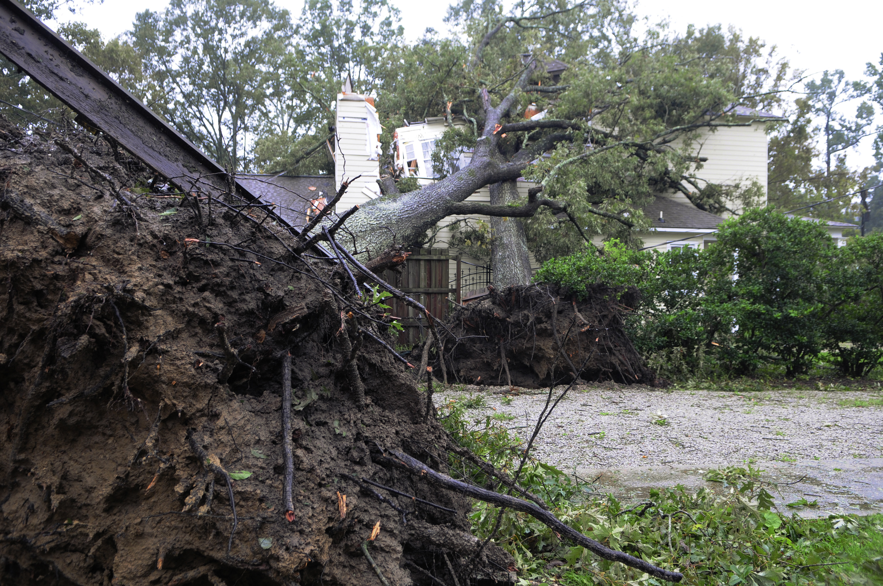
Hurricane Gustav (2008) damage in Baton Rouge, Louisiana
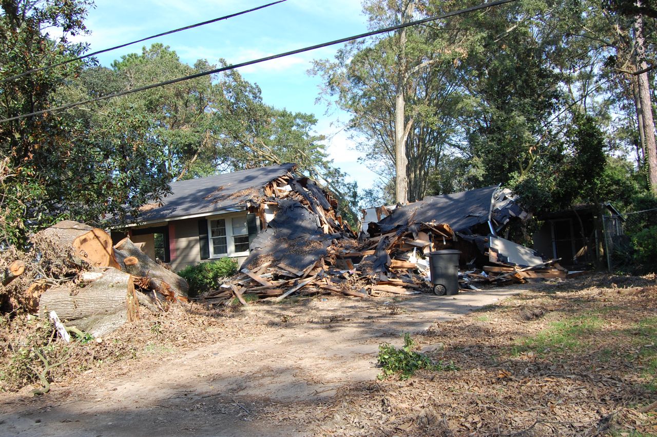
Hurricane Gustav damage in Baton Rouge, Louisiana
Two weeks after Gustav I was doing field work in Texas during Hurricane Ike. The closest I could get to landfall was the city of Orange, Texas.
Although Ike's storm surge was surprisingly high, one of the lasting images I have from that storm is a billboard sheered off and lying in the road. This damage was likely caused by "strong" tropical storm force winds, not exceeding 70 mph.
I cannot imagine living through Irma's passage in places like Naples, Fort Myers, Venice and even Sarasota. It's not imaginable for me because the force of hurricane winds quadruples as wind speeds double. Basic math tells me that the 140 mph sustained winds forecast for SW Florida are five times as destructive as the devastation I experienced from Hurricane Gustav back in 2008.
Irma is will likely weaken slightly as it approaches the Tampa metro area, but may arrive as a category-3 hurricane, which will inflict widespread destruction on the city. Although it is challenging to evacuate large metro areas, people living under trees should be particularly concerned in this region.
TAKE ACTION
It's not too late to evacuate if you live along the SW Florida coast.
Evacuation is a pain. I personally prefer to shelter-in-place with a stock pile of food and water. Last week when Hurricane Harvey hit Texas I stayed in my home in Galveston, a barrier island southeast of Houston. I am on elevated ground and I felt safe during Harvey because the main hazard in my region was torrential rain, and I live up high.
I would not feel comfortable at all staying in any coastal towns south of Tampa on the Florida Gulf Coast.
Even if I managed to survive the ordeal, my house would likely be unlivable and without utilities for weeks....why stay?
If you are in this area I would urge you to strongly consider evacuating inland to a shelter if you cannot stay with friends or in a hotel.
STORM SURGE
Irma will generate a catastrophic storm surge in Florida Keys with surge levels likely reaching 10-14 feet in Lower and Middle Keys and localized maximum levels of 14-16 feet where the eastern eyewall makes landfall. Of course, all this relies on the hurricane wind and track forecast remaining relatively accurate.
Storm surge in SW Florida could reach these same levels in areas passed by Irma's center to the west, which is most probable from Naples south.
Areas where Irma passes to the east will observe a noticeable "negative" storm surge, where saltwater is pushed out of the bays and estuaries, followed by a sudden rush of a "positive" storm surge immediately after the eye passes.
This is called "wrap around" storm surge (at least I call it that) and surge in those areas should reach around 6-10 feet.
Storm surge near Tampa is highly dependent on the storm track. However, expect a negative surge followed by a positive surge and the possibility of a 4-8 foot storm surge from hurricane force winds blowing in from the southwest after the eye passes.
Keep in mind that storm surge refers to the elevated height of sea level, but does not include the large, destructive waves that may ride on top of a storm surge. So if your first floor elevation is 12 feet and storm surge as high as 10 feet are forecast for your area, imagine a new sea level two feet below your house, with even 3-foot waves washing into your first floor. Scary stuff.
If Irma's track stays just offshore, this will mean higher storm surge for communities along Florida's west coast. It could also lead to a "shelf wave" developing from Clearwater north, as a bulge of water essentially gets trapped between the storm and the coast. This happened in Hurricane Dennis (2005) and it exacerbated storm surge for areas like Cedar Key and St. Marks.
If Irma's track stays just offshore, this will mean higher storm surge for communities along Florida's west coast. It could also lead to a "shelf wave" developing from Clearwater north, as a bulge of water essentially gets trapped between the storm and the coast. This happened in Hurricane Dennis (2005) and it exacerbated storm surge for areas like Cedar Key and St. Marks.
I like to include pics and graphics in my blog posts. However, I'm sending this as mostly text to get this out ASAP.
I'm in the car for most of today, but if you have questions or want to do an interview, please email me at: hal@marineweatherandclimate.com and I will do my best to get back to you.
Thanks and stay safe!
-Hal
How much surge is probable given the current forecast, 1:00pm EDT ?
ReplyDeleteWhere are you?
DeleteThere's an additional often under-reported dimension to this: the noise! I hunkered down for 2 hurricanes in the Outer Banks and even at Cat 1 the noise is deafening. It lasts forever, it seems, and will be unbearable, beyond a human's ability to handle it.
ReplyDeleteLast week I was in Galveston for Hurricane Harvey. Max sustained winds were in the 30s and the wind was whistling through the power lines. It is unnerving!
DeleteWhat about St Augustine and Jacksonville. Even though the beaches have evacuated, most folks in Jacksonville are staying at home.
ReplyDeleteLooks like a 3-4 foot storm surge there, based on latest advisory from the National Hurricane Center
Deletewhat about Sarasota, FL?
ReplyDeleteLatest forecast from National Hurricane Center is 5-8 ft
DeleteWhat is the latest estimate for Marco Island?
ReplyDeleteMarco Island is really in the crosshairs on this one. I think the peak observed surge could occur near Marco, or just east of there on the mainland. The possibility exists for a 13-16 ft surge in this region.
DeleteIs the surge prediction for St. Augustine still reasonable? It seems it was put in place when there was a significant probability that Irma would track up the east coast of Florida. Now that an east coast track is quite unlikely wouldn't the surge predictions for that area be reduced or eliminated? How would Irma in the Gulf of Mexico create several feet of storm surge so far north in the Atlantic so long after it moved into the Gulf?
ReplyDeleteThe latest I've seen from the NHC is a surge of 2-4 feet near St. Augustine and 4-6 feet from Fernandina Beach north. These estimates seem reasonable to me, even with the westward shift. NE FL will still observe at least strong tropical-storm force winds that will blow onshore for many hours, forcing a moderate surge with minor flooding.
DeleteWhat would you expect the storm surge to be on the bay side of Key Largo?
ReplyDeleteMy gut feeling for Key Largo is a 4-5 foot storm surge on the SE side and maybe 3-4 feet on the bay side....give or take
DeleteWhat would you say someone's safety would be if they resided in Naples and went 10 miles away from the coastline? My sister lived in Naples and left with a friend and her dog. They are taking precautions but 10 miles inward doesn't sound like enough for this bad girl Irma!
ReplyDeleteWhat would you say someone's safety would be if they resided in Naples and went 10 miles away from the coastline? My sister lives in Naples and left with a friend and her dog. They are taking precautions but 10 miles inward doesn't sound like enough for this bad girl Irma!
ReplyDeleteStorm surge risk depends on a few factors, including distance from coastline and elevation. If given enough time, a 10-foot storm surge will inundate everything under 10 feet. It's tricky to predict the duration of a storm surge event, but things definitely get worse if you are on the "strong" (right) side of the storm. Storm surge can travel inland many miles.
DeleteI think my bigger concern for your sister may be the winds. Naples could take a direct hit from Irma's eyewall, producing maximum sustained winds in the 130s to as high as 140mph. The devastation of winds like this is usually much worse than people expect.
I've experienced sustained winds in the 60s two times (in Florida and Louisiana hurricanes) and this can lead to massive tree falls and buildings shaking in the stronger gusts. Sustained winds in the 130s are twice as high, which means four times the force. I personally would not want to be there...it would be pretty terrifying.
Storm surge for Daytona Beach?
ReplyDeleteThe NHC forecast says 2-4 feet now, which I think is still reasonable, even with Irma's westward shift....
DeleteThank you for this research and testimony. I know this has helped and will continue to help others making the difficult decision to stay or go.
ReplyDeleteThank you for the encouragement!
DeleteWow, awesome stuff. Not comforting, scary.
ReplyDeleteBut fascinating. My place is in Cape Coral. Near the caloosahatchee.
Any idea how this area could be hit?