A broad area of showers and thunderstorms centered over the Southern Bahamas has an increasing chance of developing into a tropical storm over the next 48 hours. This area, now classified as INVEST-95L, will likely track towards Florida.

Infrared satellite image of Invest-95L on the morning of Thursday, September 12.
Image: Tropicaltidbits.com
The National Hurricane Center forecasts that this area has a HIGH chance of developing into Tropical Storm Humberto, with the chance of development at 70% in the next 48 hours and 80% in the next five days.

National Hurricane Center Five-Day Graphical Tropical Weather Outlook
Atmospheric models differ considerably on the potential track for Humberto, with the GFS/ American model forecasting a track that takes the storm farther west, towards the Gulf of Mexico, and the European model and others forecasting a track along Florida's east coast, and perhaps the eastern seaboard.
The GFS model tracks are shown on the map below. All of these tracks are for the same model...different tracks are forecast by slightly adjusting the initial conditions, like storm position and pressure, to initialize, or begin the model forecast.

GFS model ensemble tracks for Tropical Storm Humberto
Image: www.tropicaltidbits.com
The tracks for global and hurricane models are shown below. In general, most of these model runs forecast Humberto to track towards Florida's east coast if it develops.

Global and Hurricane model tracks for Tropical Storm Humberto
Image: www.tropicaltidbits.com
Regardless of the exact track, windy, rainy weather should be expected in Florida over the weekend and possibly into early next week. NOAA's Quantitative Precipitation Forecast (QPF) rainfall maps support this general idea, as 5-day precipitation totals are forecast to exceed 3 inches in parts of Florida and Georgia.
We should not focus on the exact locations of this precipitation forecast, but rather focus on the big picture. At this point it appears that some locations in Florida, and possibly along the Gulf Coast and Southeast U.S., are likely to observe heavy rain in the next five days.
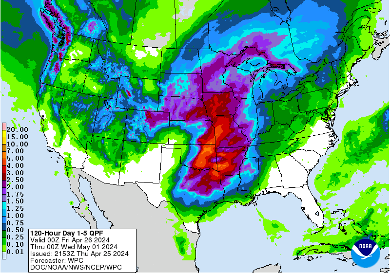
NOAA's QPF Rainfall Forecast Map depicts rainfall potential for the next 5 days
Stay tuned for more updates and keep in mind that track forecasts are likely to change considerably until a low-level circulation center develops. Yesterday evening's EURO model predicted that Humberto would develop into a hurricane and track up the Eastern Seaboard. This possibility is not out of the question...nor is potential hurricane development in the Gulf.
a framework throughout that you choose to will probably process ones niche. https://imgur.com/a/5VWPpBS http://bnpa8m6ykx.dip.jp https://imgur.com/a/NLCd85R https://imgur.com/a/NmfbcZ3 https://imgur.com/a/MCHVR5Y https://imgur.com/a/ogYI8wn https://imgur.com/a/hRVjsaX
ReplyDeleteCustomer care outsourcing service
ReplyDeleteBy choosing professional Customer care outsourcing service, you may benefit from flexibility, cheap prices, and high-calibre service.
เกม สล็อต ออนไลน์ pg slot logo เกมพนันออนไลน์ ยอดนิยมยอด นิยมเยอะที่ สุดในตอนนี้ เพราะว่าเป็นเกม ที่มีต้นแบบ การเล่น ที่ง่าย PG ต่างจากพนันอื่นๆ ที่มีความน่าตื่น ตาตื่นใจ
ReplyDeletebomb24h ถ้าหากว่าใครที่ชื่นชอบการเล่นเกมคาสิโนออนไลน์และเคยฟังชื่อ “สล็อต 888” มาก่อน อย่างแน่นอนว่าจะสงสัยว่า สล็อต 888 มีอะไรบ้างในการเล่น PG SLOT
ReplyDelete